American Pioneer & Cemetery
Research Project
Internet
Presentation
Version 0625102ND
Author: Neal Du Shane
SHERMAN, WYOMING
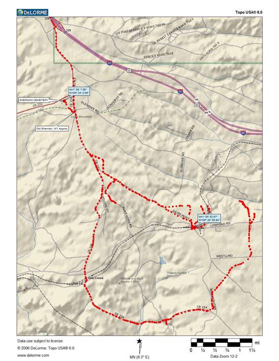
Sherman, Wyoming Topographical
Map
Provided by Author
The Ames Monument is
the major remaining evidence of the Ghost Town of Sherman, Wyoming. Plus the
derelict abandoned Pioneer Sherman Cemetery, standing silent on a windswept
hill about one quarter mile north of the monument.
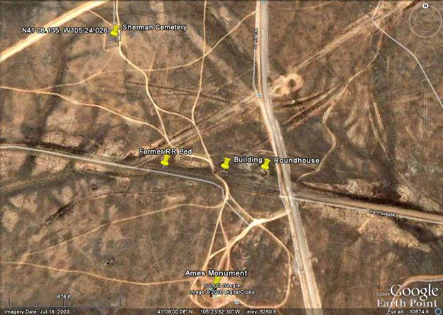
Sherman, Wyoming
Satellite Map by Neal
Du Shane
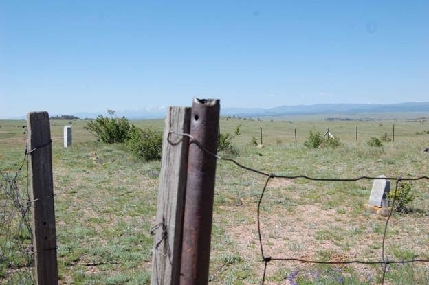
SHERMAN, WYOMING CEMETERY
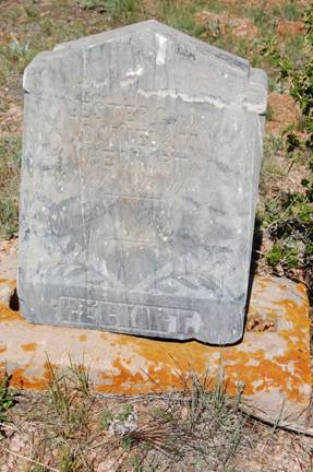
Photo by Neal Du
Shane
There is only one
headstone remaining in the Sherman Cemetery but there is evidence of many other
graves. Upon close examination of the lone remaining headstone inscription is:
“LESTER C. son of
Daniel M.
HEGKERT
Born 1882, Died 1883
At Rest
HEGKERT.”
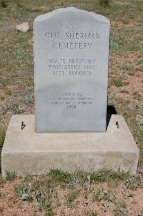
Monument erected in
1958
Photo by Author
A marker placed by
the Historical Landmark Commission of Wyoming 1958 stating “most bodies have
been removed”. We spend time researching the cemetery and our findings are as
follows.
Historic Sherman, Wyoming Pioneer
Cemetery
GPS reading N41 08
7.68, W105 24 2.06 (WGS83)
6,048 Sq. Ft. (approx.)
.14 Acres (approx.)
In 2010 it is still fenced
but one section has been trampled.
Entrance has no gate.
Total grave potential
is 118 based on Sq. Ft.
Actual graves
remaining are 53 (all unmarked except one)
One headstone
12 graves are females
41 graves are males
In addition there are
5 graves outside the fenced area, all male.
Two graves appeared
to be exhumed
Actually only one
grave was exhumed
Entrance to Historic
Sherman Cemetery
Photo by Author
Speculating the male
graves are of railroad workers and the females were in support roles to the
community, i.e. restaurant, laundry, seamstress, housewife, ceiling inspectors
etc. Strange but most of the male graves are at the front (side with the gate)
two or three rows and the females are in the last two or three rows. Not
exactly sure what this represents, if anything? Speculating if the ladies were
single “solid doves” they would not be buried as a family. There is evidence of
only one possible family plot with rocks piled around two graves, of which one
grave has been exhumed (the only exhumation). All other graves are only visible
to a trained eye or observing shrub growth, disturbed earth or a large rock
used as a headstone but no inscription was observed on any of these rocks.
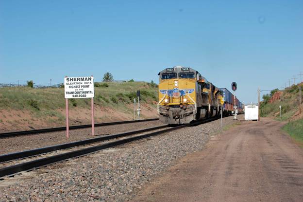
East bound Union Pacific
at current Sherman, WY
Photo by Author
Sherman existed as a
Railroad town from approximately 1867 to 1878-80 at an elevation of 8,269 Ft.
Sherman became a ghost town when the main Union Pacific Railroad tracks were
relayed a short distance to the south (3.42 Miles) at an elevation of 8,015 Ft.
a total elevation decrease of 254 ft the trains currently have to pull. Think
of this elevation reduction the size of a 20.5 story building, which is
significant in total operating expense over the years for the RR on a main
line. Today the Highest point in the Transcontinental Railroad is three miles
to the southeast of the former town of Sherman. On most maps Sherman is shown
at the current RR site but nothing remains except a siding shown in the above
photograph.
If you use Google
Earth and put in the GPS Coordinates listed above you can still trace the
original Rail Road right-of-way and observe the relocation of the RR tracks to
the south. It appears there was a spur that went from Sherman to Vedauwoo Park,
currently located off I-80 at the Wyoming 329 exit. Vedauwoo has been
identified as an Arapaho Indian word for “earth” or “Earth born”.
Information on this
historic Wyoming Ghost Town is available at:
http://userpages.aug.com/bdobson/sherman.html
SHERMAN MOUNTAINS
The
Sherman Mountains are erosional remnants rising above the general level of the
surface of the Laramie Range. The flat topped characteristic of the range resulted
from beveling during an ancient erosion cycle. Bedrock hers is granite, a
crystalline rock made up of pink fieldspar, glassy quarts, black mica and hornblende,
which originated deep in the earth’s crust over a billion years ago.
The
peculiar rock forms of the Sherman Mountains are controlled by three sets of
joints, or planes of weakness, cutting the granite and dividing it into large
blocks. Weathering has round off corners and has enlarged joint planes,
resulting in irregular blocky rock masses, many of which are capped by balanced
rocks.
TREE ROCK
|
|
|
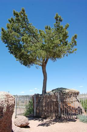
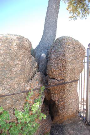
Photos
by Neal Du Shane
This
small pine tree that seems to be growing out of the solid rock has fascinated
travelers since the first train rolled past on the Union Pacific Railroad. It is said that the builders of the original
railroad diverted the tracks slightly to pass by the tree as they laid rails
across Sherman Mountain in 1867-69. It is also said that trains stopped here
while locomotive fireman “gave the tree a drink” from their water buckets. The railroad
moved several miles to the south in 1901 and the abandoned grade became a wagon
road.
In
1913 the Lincoln Highway Association was formed “To procure the establishment of
a continuous improved highway from the Atlantic to the Pacific.” The Lincoln
Highway was an instant success in a nation enamored with the newfangled automobiles
and eager for a place to drive them. The Lincoln passed right by Tree Rock as
did U.S.30 in the 1920’s and interstate 80 in the 1960’s. At this place the road
was approaching the 8,835-foot Sherman Summit, the highest point on the
Lincoln. The view of the surrounding mountains was like nothing that the west
bound easterners had ever seen. Still, they noticed the little tree, which
became the favored subject of many early postcards and photographs and still
it.
The
tree is a somewhat stunted and twisted limber pine (Pinus Flexilis), at type of
tree commonly found in this area where ponderosa and limber pines dominate the
landscape. The age of the trees is unknown, although limber pines can live as
long as 2,000 years. The tree grows out of a crack in a boulder of Precambrian
era pink Sherman granite formed more than 1 - 4 billion years ago.
American
Pioneer & Cemetery
Research Project
Internet
Presentation
Version 0625102ND
WebMaster:
Neal Du Shane
Copyright © 2010 Neal Du Shane
all rights reserved. Information contained within this website may be used
for personal family history purposes, but not for financial profit of any kind.
All contents of this website are willed to the American Pioneer & Cemetery Research
Project (APCRP).