HOME | BOOSTER | CEMETERIES | EDUCATION
| GHOST TOWNS
| HEADSTONE
MINOTTO
|PICTURES
| ROADS
| JACK SWILLING
| TEN DAY TRAMPS
Presentation
Version 072107
Editors Note:
Research continues on this historic
Table of Contents
Picture of one of three possible
cemeteries at Gilbert
There has been historical confusion regarding the Ghost
Towns of Sayers and Gilbert, it has been written they were one in the same.
Which is incorrect, physically they were one mile apart on
The Ghost Town of Gilbert resides northeast of Wickenburg. Today nothing remains and is on posted private property, please do not trespass.
Gilbert was a community that served mines in and about the
immediate area encompassing a mile or two radius. Gilbert was at the intersection
of King Solomon Gulch and
The stagecoach from Wickenburg traveled through Gilbert on its journey up the road north to Constellation going through Keystone on its journey to O’Brien Gulch. The end of the road would have been the O’Brien Mine, aka Gold Belt Mine in later years.
According to Historian Pat Ryland: The great registers show that people still lived in Gilbert as late as 1907. Members of the Kerkes family lived there until about 1920.
Historian Pat Ryland informs us that the Gilbert Post Office closed on Nov. 14, 1903 after four years of operation.
There is a cemetery (possibly three) with many outlying graves outside the main fenced area. In all there may be as many as 30 graves scattered about the area. To date we have documented and recorded eleven names out of the possible 30 graves.
Gilbert served as a commerce center for major mines in the
area.
Picture of One of three possible cemeteries at Gilbert
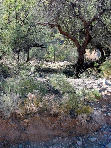
Photo by: Neal Du Shane c. 2006
Gilbert Cemeteries
|
|
||||||
|
|
||||||
|
|
||||||
|
Possibly three individual
cemeteries in this general area. |
||||||
|
From
Wickenburg follow the |
||||||
|
|
|
|
|
|
|
|
|
#1 - |
||||||
|
Lat. N34, Long. W112 (NAD 27) (Elev. 3381) |
||||||
|
|
|
|
|
|
|
|
|
|
COMBINED |
|
22 |
|
|
|
|
|
|
|
|
|
|
6/27/2007 |
|
Marker |
SURNAME |
FIRST NAME |
MIDDLE NAME |
BIRTH DATE |
DEATH DATE |
COMMENTS |
|
|
|
|
|
|
|
|
|
N |
BODIROGA |
Child |
|
|
|
Simo/Sam
& Mila Bodiroga Parents |
|
N |
BODIROGA |
Petar |
|
|
|
Uncle
of Wesley Bodiroga, brother of Sam |
|
N |
CORE |
|
|
|
|
|
|
|
DOE |
John |
|
|
|
Dowsing
revealed - adult male |
|
|
DOE |
Jane |
|
|
|
|
|
N |
KERKES |
Female |
Child |
|
|
Milan/Mike
& Annie Kerkes Parents |
|
N |
KERKES |
Female |
Child |
|
|
Milan/Mike
& Annie Kerkes Parents |
|
N |
KUKURUZOVIC |
Anton |
|
|
1923-1930 |
In
the 1920's changed last name to Lucas. |
|
N |
KUKURUZOVIC |
Katherine |
Margaretic |
|
|
Possibly
Kate was buried in |
|
N |
|
Dennis |
|
|
Jul.
5, 1902 |
From
newspaper article. P. Ryland |
|
N |
ROSS |
|
Spencer |
11/11/1919 |
11/1972 |
May
have died around 1966 - By Tonya Kipp granddaughter |
|
N |
ROSS |
|
|
|
|
Father
of |
|
N |
ROSS |
|
|
|
|
Mother
of |
|
|
|
|
|
|
|
|
|
|
13 |
|
|
|
|
|
|
|
|
|
|
|
|
|
|
#2 - |
||||||
|
|
|
|
|
|
|
|
|
Lat. N34, Long. W112 (WGS 84) (Elevation
3,376) |
||||||
|
|
|
|
|
|
|
|
|
|
Burials = |
9 |
|
|
|
12/12/2006 |
|
Marker |
SURNAME |
FIRST NAME |
MIDDLE NAME |
BIRTH DATE |
DEATH DATE |
COMMENTS |
|
|
|
|
|
|
|
|
|
N |
DOE |
John |
|
|
|
Dowsing
revealed - adult male |
|
N |
DOE |
John |
|
|
|
Pile
of Stone - No records currently available |
|
N |
DOE |
John |
|
|
|
Pile
of Stone - No records currently available |
|
N |
DOE |
John
|
|
|
|
Dowsing
revealed - adult male |
|
N |
DOE |
John |
|
|
|
Dowsing
revealed - adult male |
|
N |
DOE |
John |
|
|
|
Dowsing
revealed - adult male |
|
N |
DOE |
John |
|
|
|
Dowsing
revealed - adult male |
|
N |
DOE |
John |
|
|
|
Dowsing
revealed - adult male |
|
N |
DOE |
John |
|
|
|
Dowsing
revealed - adult male |
|
|
|
|
|
|
|
|
|
|
9 |
|
|
|
|
|
|
|
|
|
|
|
|
|
|
#3 - |
||||||
|
|
|
|
|
|
|
|
|
Marker |
SURNAME |
FIRST NAME |
MIDDLE NAME |
BIRTH DATE |
DEATH DATE |
COMMENTS |
|
|
|
|
|
|
|
|
|
Lat. N34, Long. W112 (WGS
84) (Elevation 3,481) |
||||||
|
|
|
|
|
|
|
|
|
|
|
|
|
|
|
|
|
|
|
|
|
|
|
|
|
|
|
|
|
|
|
|
|
|
|
|
|
|
|
|
|
Contributor: Neal Du Shane © All Rights Reserved |
||||||
|
|
|
|
|
|
|
|
|
SUBMITTER: |
Neal Du Shane –
Tonya Kipp - Allan Hall - Pat Ryland |
|||||
|
|
|
|
|
|
|
|
|
UPDATED: |
7/21/2007 Neal Du
Shane |
|
|
|||
|
|
|
|
|
|
|
|
|
Material may be
freely used by non-commercial entities, as long as this |
||||||
|
message remains on
all copied material, AND permission is obtained from |
||||||
|
the contributor of
the file. |
|
|
|
|||
|
|
|
|
|
|
|
|
|
No permission will be granted to make
changes in GPS readings, directions, nor can they be altered or omitted from
this document. |
||||||
|
|
|
|
|
|
|
|
|
These electronic pages
may NOT be reproduced in any format for profit |
||||||
|
or presentation by
other organizations. Persons or organizations |
||||||
|
Desiring
to use this material for non-commercial purposes, MUST obtain |
||||||
|
the
written consent of the contributor, OR the legal representative of |
||||||
|
the
submitter, and contact the listed archivist with proof of this consent. |
||||||
|
|
|
|
|
|
|
|
|
|
|
|
|
|
|
|
|
|
|
|
|
|
|
|
|
This file was contributed for free use. |
||||||
|
Contributor/Archives by: Neal Du Shane (C) - All rights reserved |
||||||
Dennis Lawton’s Death
Newspaper articles report July 4, 1902 was a day to remember in respect to celebrating at Gilbert. Dennis Lawton’s died the following day from causes unknown at this point, we can only speculate as to his cause of death.
Photograph by: Allan Hall 07/17/07
Current Day Gilbert
7/17/07 by: Allan Hall
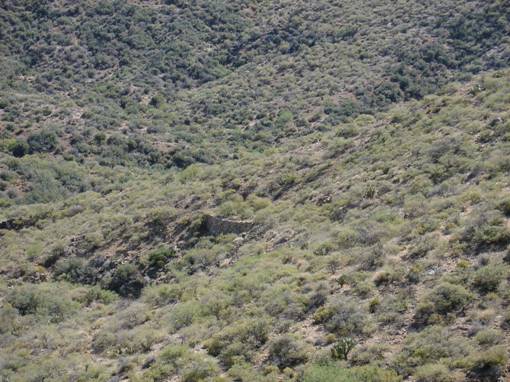
I have had the opportunity now to view some of the old trails
that passed through the Gilbert area when I went up to Key Stone Mine and
This area is crisscrossed with old trails that do not show up on modern maps or even the 1905 (or older) map that you provided.
This is particularly true of the area east and south of
Once you get some elevation on the surrounding area it is pretty easy to see that the Gilbert settlement was a major junction of mining roads and pack trails.
Attached is a photo of an old road that is east of the
Gilbert cemetery and south of modern day
As you can see, this section of road had a pretty impressive retaining wall.
Gilbert , AZ
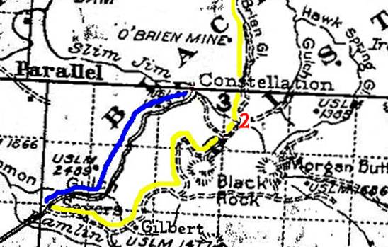
Blue line on the above map represents current day
APCRP Internet Edition 072107
Web Master: Neal Du Shane
Copyright ©2003-2007 Neal Du Shane
All rights reserved. Information contained within this website may be
used
for personal family history purposes, but not for financial profit of any
kind.
All contents of this website are willed to the American Pioneer &
Cemetery Research Project (APCRP).
HOME | BOOSTER | CEMETERIES | EDUCATION
| GHOST TOWNS
| HEADSTONE
MINOTTO
|PICTURES
| ROADS
| JACK SWILLING
| TEN DAY TRAMPS