HOME | BOOSTER | CEMETERIES | EDUCATION
| GHOST TOWNS
| HEADSTONE
MINOTTO |PICTURES | ROADS | JACK SWILLING | TEN DAY TRAMPS
Presentation
Version 082007
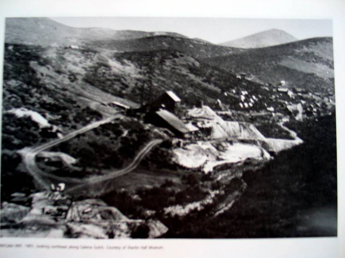
Table of Contents
McCarty Family section
of McCabe Cemetery Photograph
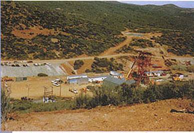
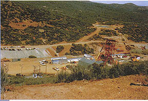
McCabe Mine Reclamation 1990’s
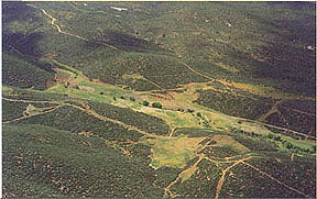
The Ghost Town of McCabe is located in Yavapai, AZ - Township 13 N, Range 1 E. at an elevation of approximately 5,000 ft.
McCabe was an active mining town at the turn of the
twentieth century. Located in the
In 1864, gold was discovered in the area and a mill was erected at King Woolsey’s Ranch. Four years later the gulch was abandoned until 1883 when Frank McCabe found gold in Galena Gulch. By 1900 there were stores, school, hospital, saloons and assay offices in McCabe.
A strong labor union, the Western Federation of Miners, won reduction in the workday from ten to 8 hours without loss of pay.
The town had electricity, telephone and flush toilets. During the peak years, 1900-1907, 400-600 people were living there. In 1913 the mine closed.
A fire destroyed the town and over the years vandalism and
nature left only tailings, a few rocks formations, and a portion of the
cemetery. More of the cemetery was
washed away by a flood in 1937 Today McCabe is one of
McCarty Family section of McCabe Cemetery Photograph
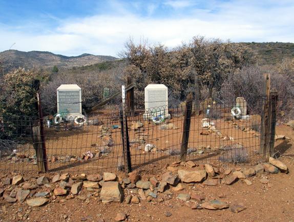
Photograph by: Neal Du Shane 2005
McCabe Cemetery
|
|
||||||
|
|
|
|
|
|
|
|
|
Ghost Town of McCabe, W.
of Humboldt, |
||||||
|
|
|
|
|
|
|
|
|
Highway 69 just S. of Humboldt, take the |
||||||
|
|
|
|
|
|
|
|
|
Latitude N34 29.389, Longitude W112 17.273
- (Elevation 5,060) |
||||||
|
|
|
|
|
|
|
|
|
|
Burials = |
24 |
|
|
|
7/19/2007 |
|
Marker |
SURNAME |
FIRST NAME |
MIDDLE NAME |
BIRTH DATE |
DEATH DATE |
COMMENTS |
|
|
|
|
|
|
|
|
|
N |
DENNY |
Alex |
|
No dates |
No dates |
From
Cathy Cordes Grandfathers book |
|
N |
DOE |
Jane |
|
|
|
Unmarked
interment |
|
N |
DOE |
Jane |
|
|
|
Unmarked
interment |
|
N |
DOE |
Jane |
|
|
|
Unmarked
interment |
|
N |
DOE |
Jane |
|
|
|
Unmarked
interment |
|
Y |
DOE |
John |
|
|
|
No
Information on the marker |
|
Y |
DOE |
John |
|
|
|
No
Information on the marker |
|
N |
DOE |
John |
|
|
|
Unmarked
interment |
|
N |
DOE |
John |
|
|
|
Unmarked
interment |
|
N |
DOE |
John |
|
|
|
Unmarked
interment |
|
N |
DOE |
John |
|
|
|
Unmarked
interment |
|
N |
DOE |
John |
|
|
|
Unmarked
interment |
|
Y |
DOE |
John |
|
|
|
No
Information on the marker |
|
N |
McCARTY |
Jack |
C. |
1879 |
1925 |
From
Cathy Cordes Grandfathers book |
|
N |
McCARTY |
Jane Doe |
|
|
|
In
McCarty enclosure (Child-female) |
|
Y |
McCARTY |
John Doe |
|
|
|
In
McCarty enclosure (Child-male) |
|
Y |
McCARTY |
John Doe |
|
|
|
In
McCarty enclosure (Child-male) |
|
N |
McCARTY |
John Doe |
|
|
|
In
McCarty enclosure (Child-male) |
|
Y |
McCARTY |
Martha |
Ellen |
Aug.
24, 1845 |
Feb.
4, 1916 |
Age:
70 Yrs. 5 Mos. 11 Days - Gone But Not Forgotten. |
|
Y |
McCARTY |
Thomas |
H. |
Jan. 20, 1844 |
Aug.
29, 1910 |
Age:
66 yrs, 7 Months, 9 Dys - Gone But Not Forgotten - Blacksmith |
|
N |
MILLIGAN |
Harry |
George |
Jun. 2, 1884 |
Apr. 14, 1902 |
Unmarked
internment, Parents: Jonathan Milligan & Arabelle Rathburn, parents
resided in Yabor Gulch, COD pneumonia |
|
N |
REICHELT |
Baby |
|
|
1906 |
|
|
N |
REICHELT |
|
|
|
1906 |
|
|
Y |
THOMAS |
D. |
H. |
Aug. 7, 1831 |
Sep. 24, 1906 |
Gone
But Not Forgotten |
|
Y |
W---S |
M. |
|
Aug 30, ???? |
|
It's
possible this reads Age 30? Headstone is Sandstone and decaying |
|
|
|
|
|
|
|
|
|
9 |
24 |
|
|
|
|
|
|
|
|
|
|
|
|
|
|
Research by: |
Cathy Cordes, Neal
Du Shane, Gene Simonds |
|||||
|
|
|
Mary Belle Smith -
family member of Harry Milligan provided info. |
||||
|
|
|
|
|
|
|
|
|
Revised: |
09/19/07 Neal Du
Shane |
|
|
|||
|
|
|
|
|
|
|
|
|
Contributor: Neal Du Shane: Research of the general
area found possible additional unmarked burials. 75% of the enclosure is
currently overgrown with dense shrubs. Based on the size of the fenced
enclosure its possible 300 or 400 unmarked graves may be at this cemetery. |
||||||
|
|
|
|
|
|
|
|
|
Material may be
freely used in it's exact format and cannot be changed or altered, |
||||||
|
by non-commercial
entities, as long as this message remains on all copied material, |
||||||
|
AND written
permission is obtained from the contributor of the file. |
||||||
|
|
|
|
|
|
|
|
|
These electronic
pages may NOT be reproduced, in any format for profit |
||||||
|
or presentation by
other organizations. Persons or organizations |
||||||
|
desiring to use
this material for non-commercial purposes, MUST obtain |
||||||
|
the written
consent of the contributor, OR the legal representative of |
||||||
|
the contributor,
and contact the archivist with proof of this consent. |
||||||
|
|
|
|
|
|
|
|
|
This file was contributed exclusively at no
charge and free from any charge. |
||||||
|
Contributor/Archives by: Neal Du Shane - All rights reserved © |
||||||
McCabe's post office was established December 31, 1897 and was discontinued October 31, 1917. All that is left today at McCabe is some mining equipment and the cemetery with headstones still readable.
Approximately 600 people lived here and McCabe even had a six bed hospital. McCabe was plagued with bad luck. First, there were several fires, one of which burned 14 buildings on July 5, 1900. Then, a small pox epidemic in 1901 necessitated a quarantine barrier. 1913 marked the closing of the mine and the town slowly died.
McCabe was one of the few towns to actually have a telephone
line running to
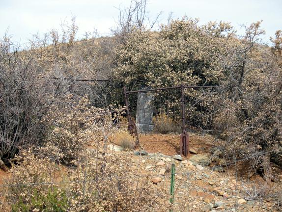
Derelict abandoned grave at
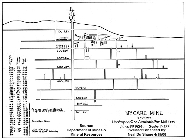
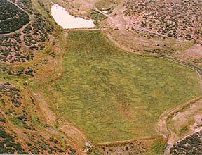
Map of McCabe Mine
McCabe Mine Reclamation 1990’s
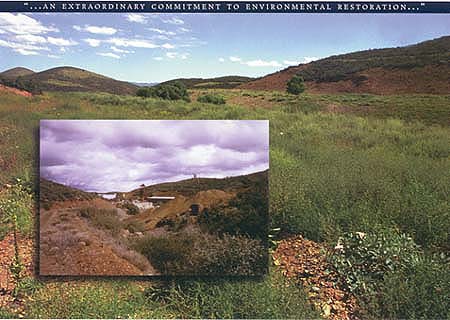
RECLAMATION SUCCESS
BHP Copper, McCabe Mine Reclamation Project
Broken Hill
Proprietary Company Ltd. (BHP) is a global company with business in four
natural resources: copper, minerals, petroleum, and steel. The McCabe Mine in
northern
|
For many years, this area has been used for mining gold. |
Before and after reclamation of the McCabe mine site |
|
|
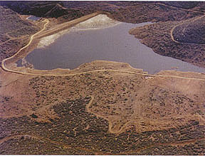
Reclamation activities of the mine site required permits to control the quality of the surface and ground waters. Many tests were performed to determine the environmental impact the mining had on this region. Once the tests had been conducted, steps could be taken to begin the revegetation process. The following photographs provide an example of the reclamation of the ponds and surrounding areas. |
|
Tailings impoundment prior to reclamation |
Completed tailings impoundment after reclamation |
|
The water and ground materials were tested to ensure no contamination was present. If resources were of high enough quality, they were incorporated with the rebuilding process. For example water, from the various ponds, was used to irrigate the new vegetation. The areas were covered with waste rock materials and soil. Seed mixtures were then spread over the areas to start plant growth. The area had to be re-shaped with the building of diversion ditches and a retention dam to prevent the accumulation of rainwater. |
|
|
The revegetation efforts were very successful. The foliage became dense with flowers and native grasses. The land is currently used for wildlife habitat and livestock grazing. The McCabe mine provides an example of how a site is returned to a natural state after it has been mined for its resources. |
|
APCRP Internet Publication
All Rights Reserved © 2007 APCRP
WebMaster: Neal Du Shane
Copyright ©2003-2007 Neal Du Shane
All rights reserved. Information contained within this website may be
used
for personal family history purposes, but not for financial profit of any
kind.
All contents of this website are willed to the American Pioneer &
Cemetery Research Project (APCRP).
HOME | BOOSTER | CEMETERIES | EDUCATION
| GHOST TOWNS
| HEADSTONE
MINOTTO |PICTURES | ROADS | JACK SWILLING | TEN DAY TRAMPS