HOME | BOOSTER | CEMETERIES | EDUCATION
| GHOST TOWNS
| HEADSTONE
MINOTTO |PICTURES | ROADS | JACK SWILLING | TEN DAY TRAMPS
Presentation
_____________________________________________________
Exploring
the Lower Slim
By: Allan G. Hall
Edition 081107
Introduction
If
you enjoy hiking, photography and the history and geology of the area east of
Wickenburg, then I recommend a hike down
My Definition of Slim
For
purposes of this article, I divide the route into three geographically unequal
but logical and convenient segments:
![]()
![]()
![]()
This
article is confined to
How to Get There
The
GPS coordinates provided in this article are listed in NAD27 format: DDD-MM-SS.S.
Conversion to alternate reference systems will be up to the reader. All location references may be found on the
USGS Morgan Butte Quadrangle, Grid numbers 4-5 and 31-32. See the later section titled “Travel &
Hiking Coordinates” for more details.
Access
to
Along
the way you will pass a shaft of the Texas Group Mine on your right. Shortly after this point, at a distance of
about one mile to your right (northeast) you will also see the Black Rock Mine;
which will be addressed in the next article.
As you proceed along the trail you will come to a cattle gate separating
the grazing leases of the JV Bar and Williams ranches. This gate has been closed each time I have passed
through the area, so I recommend that you close it after passing through. From this point until you reach the creek, I
recommend that you use lower 4WD gears and proceed slowly to help
preserve the condition of the trail.
Upon reaching the creek bed, you will turn left and proceed down (WNW)
4WD
and ATV vehicles can travel down the creek as far as the trailhead to the
ATOS/George Washington Mine, which departs the creek bed at GPS: 34 o
04’ 34N by 112 o 35’ 47”W (located in Grid #32 of the Morgan Butte
Quadrangle). There is modest space to
park one or two vehicles without obstructing access to the ATOS trail. From this point forward you should be on
foot. Although it is possible to
continue a short distance beyond this point on an ATV, doing so virtually
guarantees that you will see no wildlife.
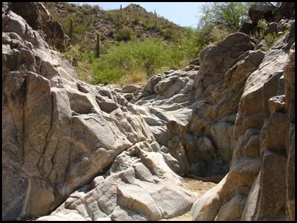
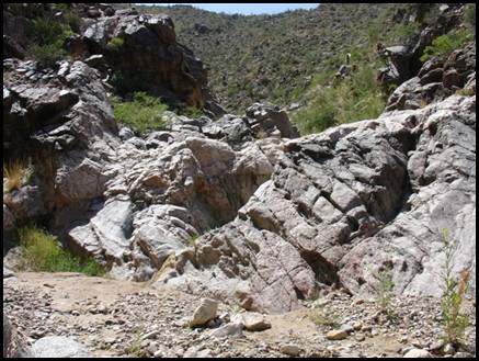
Hiking in Lower Slim Jim
Turn
left upon entering the creek. You will
find yourself in a rather broad, sandy wash that initially heads in a
northwesterly direction. At this point
the creek will appear to be unremarkable; but this view will quickly change! The creek will become more constricted as you
begin a series of bends and turns and you will soon encounter the first
examples of the fascinating geology in the creek, as evidenced in Figures 1 and
2.
Figures 1 & 2.
Geology in Lower Slim
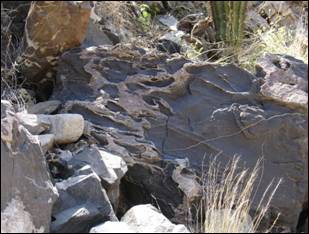
Seams
and bands of volcanic extrusion rock characterize
By
the way, don’t stow your camera on the way back out! The light conditions and time of day in
Figures
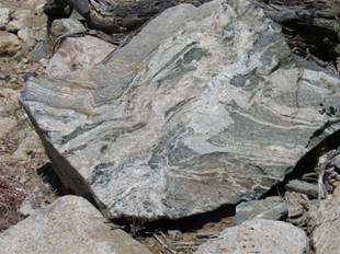
3 and 4 provide further examples of the rock formations in Slim Jim. These photos show the two most significant
granite dikes that cross the creek bed.
There are no practical routes around these dikes; so you will need to
scale your way up and down them. Each
photo view is taken from below the respective dike looking upstream.
Figure 3.
Granite Dike in Lower Slim
The
dike in Figure 3 is approximately eight feet in height at the point where you
descend. There are ample spots to
establish safe footing as you climb this location as well as the dike in Figure
4. The vertical height of the next dike
is probably closer to twelve feet at the point of ascent/descent.
Figure 4.
Additional Granite Dike Formation
A
few hundred yards beyond the ATOS trailhead you will arrive at a location that
has been fenced off in the creek bed.
This is the site of a placer claim that appears to be active, although
it is not continuously worked. See
Figure 5. I have yet to encounter anyone
at this site, but I would urge caution and respect as you pass through the
area. As the old saying goes, “Friendly
is as friendly does.”
Figure 5.
Placer Claim in Lower Slim
The
fence is actually another grazing boundary line. Up to this point you will have been crossing
Williams Ranch grazing land. There is no
gate at this location so you will have to pass through the barbed wire on
foot. As you pass through the fence to
this placer claim, you will be reentering JV Bar Ranch grazing areas which
extend several miles to the north of the
The
topology of the lower segment of the creek bed would not have been favorable to
the establishment of mining settlements.
Because it is both narrow and the sides are quite steep, this area is
particularly prone to heavy runoff during the storm seasons. I can easily imagine that miners would have
avoided building houses in this area.
There are settlements in and adjacent to the middle and upper segments
of
This
does not mean that
As
you near the end of
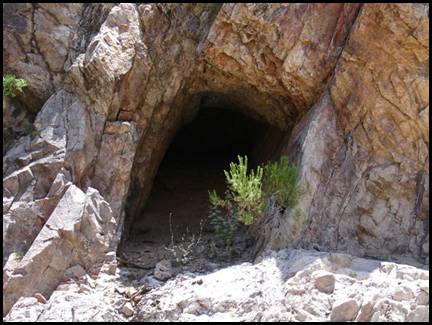
Figure 6.
East Tunnel in Lower Slim
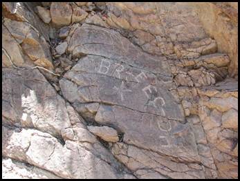
Quite
near the two lower tunnels there is an inscription chiseled into the rock wall
on the west side of the creek. See
Figure 7. The inscription shows three
sets of initials, “BR-EEC-DH”, and a “cross” or possibly “plus” symbol. No date is included in the inscription, so it
is not possible to determine anything other than what the photo shows. Close examination reveals a very fine and
precise effort was made in the inscription.
Whether this was intended as a memorial to three individuals, or whether
it was a “tunnel squatter” with a lot of time on his hands, we will probably
never know.
Figure 7. Inscriptions
Vegetation in Lower Slim
The
vegetation in
Flowering
plants will include Mexican Poppy, Brittle Bush, Desert Marigold and
Globemallow, as well as many lesser-known species in the creek bed and on the
hillsides. I did not see any Mariposa
Lily this year (2007), but the lack of rain in the past three years is probably
a factor. Naturally, you will see a profusion
of Jojoba bushes and many
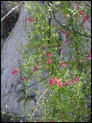
If
you are seeking views of uncommon species, you will be rewarded with plants
such as the Twining Snapdragon vine, as illustrated in Figure 8. This specimen is located west of the ATOS
trailhead in the creek and produces blooms from April through October.
Figure 8.
Twining Snapdragon
Once
you reach the terminus of the creek at the
Wildlife in Lower Slim
The
creek bed will contain many tracks of coyotes, fox, squirrels, deer and
javelina in the first half of this hike.
I have seen deer, quail, Gila Monsters, a variety of interesting lizards
and, of course, snakes while hiking through the creek.
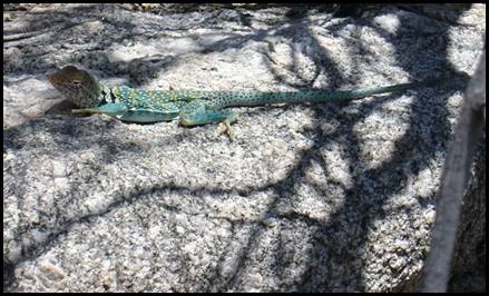
Figure 9.
Eastern Collared Lizard – Crotaphytus
collaris
If
you are also a bird enthusiast, you will particularly enjoy the areas upstream
and downstream along the
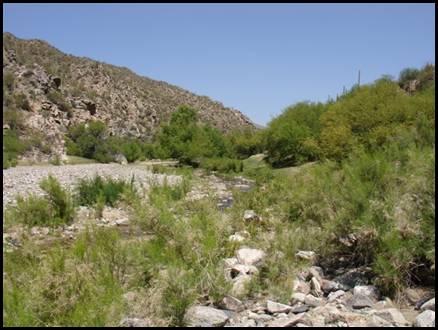
The River
Elevation
at the junction of the
Figure 10.
After
a rest and lunch, it will be time to head back up the creek to your
vehicle. Changing light conditions in
the wash will reward you with as many photographic opportunities on the return
as you had hiking down. I recommend that
you time your exit so that you will reach
Footnotes
The
oldest maps we have been able to locate for this area range from 1904 to
1885. That span of time closely
approximates the most significant mine development in this area and the maps
show the emergence and disappearance of numerous trails. It is safe to say that many of the trails are
more than 110 years old and some can be dated to 125 years or older.
Slim
The
stream bed renews itself after every runoff from storms – it is cleansed (at
least temporarily) of all evidence of human passage. The old mine trails that lead into
Before You Go
Regardless
of the time of year that you choose to explore lower
![]() Let someone know specifically where you are going before you
depart and when you plan to
return. If you get in trouble you will
have to hike several miles before you reach a cell phone signal!
Let someone know specifically where you are going before you
depart and when you plan to
return. If you get in trouble you will
have to hike several miles before you reach a cell phone signal!
![]() Bring plenty of water and energy snacks. Depending on the season that you hike, your
need for water could vary greatly.
Remember that what you hiked “down,” you will be hiking “up” on the way
out. Your energy expenditure and need
for water will increase. I characterize
this hike as “moderate” in the scale of effort required.
Bring plenty of water and energy snacks. Depending on the season that you hike, your
need for water could vary greatly.
Remember that what you hiked “down,” you will be hiking “up” on the way
out. Your energy expenditure and need
for water will increase. I characterize
this hike as “moderate” in the scale of effort required.
![]() Make sure that you are properly hydrated before you
start. For the record, I carry four to
six pints of water in my backpack for this section of the creek, but I also
have additional water in the cooler after returning to my vehicle. During the warmer season you might even
consider making a “water drop” somewhere along the hike so that you will have a
cache on your way out.
Make sure that you are properly hydrated before you
start. For the record, I carry four to
six pints of water in my backpack for this section of the creek, but I also
have additional water in the cooler after returning to my vehicle. During the warmer season you might even
consider making a “water drop” somewhere along the hike so that you will have a
cache on your way out.
![]() Appropriate clothing, including hiking shoes with good, firm
soles and a hat is essential. You might
also consider bringing a pair of leather gloves.
Appropriate clothing, including hiking shoes with good, firm
soles and a hat is essential. You might
also consider bringing a pair of leather gloves.
![]() Allow a combined travel and hiking time of at least six
hours. If you decide to hike up or
downstream along the
Allow a combined travel and hiking time of at least six
hours. If you decide to hike up or
downstream along the
Precautions
![]() At the time of publication, there is a placer mine claim in
the creek bed a few hundred yards downstream and west of the ATOS
trailhead. This claim appears to be
active, although not continuously worked.
This is public land and you have a right to pass through the area. Be courteous and respect the claim-owner’s
rights.
At the time of publication, there is a placer mine claim in
the creek bed a few hundred yards downstream and west of the ATOS
trailhead. This claim appears to be
active, although not continuously worked.
This is public land and you have a right to pass through the area. Be courteous and respect the claim-owner’s
rights.
![]() From mid-April through September you can expect to see
snakes. Be alert.
From mid-April through September you can expect to see
snakes. Be alert.
![]() Don’t become a statistic.
DO NOT attempt to hike this section of the creek if there are heavy
storms in the upper watershed. The drop
in elevation between the peaks at the top end of
Don’t become a statistic.
DO NOT attempt to hike this section of the creek if there are heavy
storms in the upper watershed. The drop
in elevation between the peaks at the top end of
![]() Know and understand your own capabilities. If you are a “cool weather” hiker, you may
want to defer hiking in
Know and understand your own capabilities. If you are a “cool weather” hiker, you may
want to defer hiking in
![]() The sand-gravel mix in the lower creek bed compacts very
nicely in dry conditions. If you enter
the area with a vehicle after a heavy runoff, I cannot guarantee that you will
not experience problems. Be aware of the
conditions and don’t overestimate the capabilities of your 4WD or ATV vehicle.
The sand-gravel mix in the lower creek bed compacts very
nicely in dry conditions. If you enter
the area with a vehicle after a heavy runoff, I cannot guarantee that you will
not experience problems. Be aware of the
conditions and don’t overestimate the capabilities of your 4WD or ATV vehicle.
![]() Plan to take photos and leave only footprints. Pack out what you carry in! The
Plan to take photos and leave only footprints. Pack out what you carry in! The
Travel & Hiking
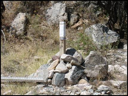
Coordinates
As
previously stated, all coordinates are listed in 1927 North American Datum,
(NAD27), which appears on USGS Quad maps.
1.
Distance from the Wickenburg Rodeo Grounds to the lower
2.
Turnoff from
34o 03’ 54”N by 112 o
35’ 04” W - Morgan Butte Grid #4
3.
Entrance to lower
34 o 04’ 26”N by 112 o
35’ 22”W – Morgan Butte Grid #32
Elevation is approximately 3040 ft.
4.
Location of first tunnel in
34 o 04’ 29”N by 112 o
35’ 41”W – Morgan Butte Grid #32
5.
Trailhead to ATOS Mine and second tunnel in lower
34 o 04’ 34”N by 112 o
35’ 47”W – Morgan Butte Grid #32
Hiking
distance from ATOS trailhead to
Lower
Slim
34
o 04’ 56.9N by 112 o 36’ 55.2”W – Morgan Butte Grid #31
Elevation
is approximately 2520 ft.
If
you have any questions about directions or content of this article, please drop
me a note via the APCRP web site.
All Rights Reserved
Version 052807
APCRP Internet Presentation
WebMaster: Neal Du Shane
HOME | BOOSTER | CEMETERIES | EDUCATION
| GHOST TOWNS
| HEADSTONE
MINOTTO
|PICTURES
| ROADS
| JACK SWILLING
| TEN DAY TRAMPS