HOME | BOOSTER | CEMETERIES
| EDUCATION
| GHOST TOWNS
| HEADSTONE
MINOTTO |PICTURES | ROADS | JACK SWILLING | TEN DAY TRAMPS
Internet Presentation
Sayers Spring
A.K.A. Sayers, Sayers Station,
Sayersville
Version 112207
By: Neal Du Shane
Obituary of George Sayers
George Sayers
August 11, 1909
Wickenburg - George
Sayers was loading a wagon with merchandise from his general store in
Sayersville yesterday for transportation to Octave when suddenly the explosion
of a shotgun rang out. A number of old timers who were in the store ran out and
found Mr. Sayers lying on the ground with one side almost torn away and covered
with blood. He was rushed in critical condition to Octave, a distance of about
seven miles where there was a surgeon. Mr. Sayers always kept a loaded shotgun
in the bottom of his wagon and it is surmised that while loading up he struck
the hammer with a box of merchandise causing it to explode.
George Sayers is a
prince of a good fellow. It is known that he never turned away a wanderer of
the hills who was really in want.
CLARIFICATION: Sayers, a.k.a. Sayers Station,
Sayers Spring has incorrectly been referred to as Gilbert. Our documented
research places Gilbert one mile farther up
December 13, 2006 found me at Sayers Spring investigating several reports of graves in and about the general area. After wandering the ruins of the store that was once Sayers Station, it was reported there is three graves up the hill behind the store foundation closer to the spring.
Looking as I walked up the trail I came to a flat area that had a corrugated metal lean-to that looked like it might be remnants from the 1960’s generation for hippies central.
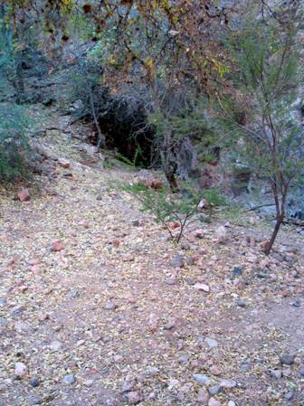
Figure 1
Lower Spring –
Across this small level area in the mountain rock, is a small pool where moss in the water is standing tranquil and silent. (Figure 1) Immediately to my left approximately 15 feet along the face of the rock wall, I spotted a rock with the name “Rick with a cross on it”. (Figure 2) It looked like the cross and letters had been sand blasted into the rock. It isn’t a granite or marble rock and didn’t look to be officially a headstone you would purchase but none the less the lettering and cross did look professionally engraved.
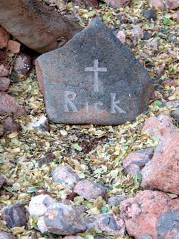
Figure 2
Grave marker –
Often headstone can be relocated, and are not actually where the interment is. This headstone is of the size that it could easily be moved being no larger in size than 12” X 16”.
Walked back to my vehicle and gathered up my dowsing rods and went back to the headstone. Verified there is a short adult male buried there or a teenager. After walking the general plateau I found two more unmarked adult graves, one male and one female. Cattle tracks were in this area and they must use this as their watering spot although there are water tanks and a windmill close at hand. Their general destruction to the area is the demise of any evidence of the two other graves. If it weren’t for the lone headstone being close to the rock face it would be trampled into the earth also.
Walked up the trail another 100’ (Figure 4) and discovered another level and an open framed window that is the retention area for Sayers Spring with ample fresh water standing in it. Obviously gravity caused the water from Sayer Spring, to flow from this high spot to the old store in its hay day.
I was told across from the Sayers Station store, (Figure 3) as you are headed on Constellation Road to the Monte Cristo, Gold Bar Mines, as you are leaving Sayer Spring and coming out of the King Solomon Gulch, immediately on the left is a driveway with a flat area that was the dance hall for Sayers. After parking at this flat area I was told there were graves across the road.
Dowsing rods in hand I proceeded up the embankment on the other side of the road. Almost immediately I came upon an adult male grave that is faintly outlined with rocks. Walked the general are and found one female adult in addition. It is possible there might be additional graves in this general area but undergrowth and brush limited my access.
As you follow
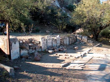
Figure 3
Foundation of the Sayers General store and Hotel.
Photo by: Neal Du Shane 2006
The actual Sayers Spring is interesting as it resides about halfway up the mountain behind Sayers store foundations. (Figure 4)Actually there are two water holding cisterns that are still visible today in the side of the mountain. At the first flat area going up the mountain there is evidence of inhabitance and three graves. Farther up the mountain is the actual spring with fresh water waiting for thirsty travelers.
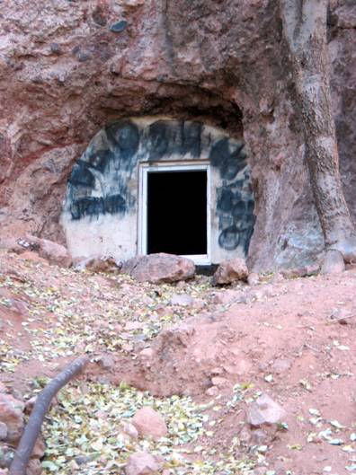
Figure 4
Sayers Spring. Photo By: Neal Du Shane 2006
Sayers, a.k.a. Sayers Station, Sayers Spring has also
incorrectly been referred to as Gilbert. Our documented research places Gilbert
one mile farther up King Solomon Gulch, at the point where
05/09/06
Sayers Station is located in King Solomon Gulch. I have located a Topographical map from 1903 that shows both the location of Constellation and Gilbert. There use to be a road further up K. Solomon Gulch from Sayers Station. This road made a loop and Gilbert was located there. Since Gilbert was built as the Post Office for King Solomon Mine, it was closer to the Mine than Sayers Station. I am currently trying to plot the so I can explore the area.
The original road departed current day Constellation Road
before Sayers Spring, followed Buckhorn Road for a short distance then turned
north past the Keystone Mine, traveled to Constellation (Slim Jim Creek) on to
O’Brien Gulch, a route farther east than the current day Constellation Road.
This route leads historians to scratch their heads as to placement of these
historic Ghost Towns as they weren’t on the present day
On the historic map below, (Figure 5) believed to be of the
1890 vintage, the yellow line is the original road back to the O’Brien Mine
(Gold Belt Mine). The Blue line indicates the current day
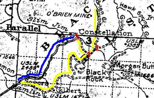
Figure 5
Map of
Scott Rogers,
The location of Constellation has been documented and was on
It is believed the original Sayersville was located at the
junction of Blue Tank
George Sayers death notice in the Arizona Republican listed his place of residency as "Sayersville". That is incorrect as he had moved to Sayers Station. Sayers Spring is located behind and uphill from Sayers Station, it is being used today by a rancher for his cattle watering.
There is a tombstone up the hill; everyone thinks it dates back to when George was there. There is a question as to its date of production. There is a monument maker in Wickenburg who is making that stone. One of the things I want to do is visit him and find out when he set the stone.
Doug Miller of the near by JV Ranch has verified the headstone with “Rick” on it was a dogs grave and Doug new the person that placed the dog there some years ago.
UPDATE: 11/21/07
Sayers grave believed found.
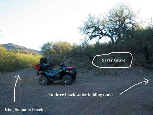
Figure 6.
Believed the final resting place of George Sayers.
Picture and drawing by: Neal Du Shane
As reported earlier from historical research George Sayers accidentally discharged a shot gun he carried for protection in the bottom of his wagon while loading supplies. He was taken to the nearest Doctor in Octave but died there as his wounds were too severe for surgeons of that era. No documentation has been found as to where he was interred but logic implied it was likely at Sayers Well/Station rather than Octave.
Research in this general area for the past two years has
revealed five graves (one being Rick the dog). The terrain is rugged with
mountains on one side and
This landscape is hard to navigate and thus suitable grave locations are limited. The creek isn’t suitable do to flooding and destruction caused by rushing water to graves.
Research was conducted at the original location of Sayers at
Blue Tank
Acknowledgments: Scott Rogers, Allan Hall for their research assistance.
Internet Edition 112107
WebMaster: Neal Du Shane
Copyright ©2003-2007
Neal Du Shane
All rights reserved. Information contained within this website may be used
for personal family history purposes, but not for financial profit of any kind.
All contents of this website are willed to American
Pioneer & Cemetery
Research Project
(APCRP).
HOME | BOOSTER | CEMETERIES | EDUCATION
| GHOST TOWNS
| HEADSTONE
MINOTTO |PICTURES | ROADS | JACK SWILLING | TEN DAY TRAMPS