HOME | BOOSTER | CEMETERIES | EDUCATION | GHOST TOWNS | HEADSTONE
MINOTTO | PICTURES | ROADS | JACK SWILLING | TEN DAY TRAMPS
American Pioneer
& Cemetery Research
Project
Internet Presentation
Version 033011
Click:
BECOME AN APCRP BOOSTER

a.k.a. Basin Cemetery, Burnt
Mill Ranch Cemetery
By Kathy Block
APCRP Historian
The lure
of gold brought prospectors, land along the Colorado River brought ranchers and
settlers, and shipping of people and goods up the Colorado brought ferries on
the River to the remote Gold Basin area of Mohave County, Arizona. Modern prospectors continue to seek deposits
of gold, and there are many active claims, worked by individuals and groups. Ed
and I have made many trips to Mohave Prospectors Association claims in an area off
Gregg’s Hideout Road.
|
|
|
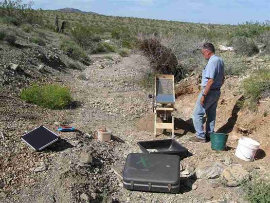

Ed Block -
Present day dry washing - Results from dry
washing 4 large buckets of screened material
Then,
researching Gold Basin I came across a web site, “One Day Trips in the Meadview
Area” by Mike Kelly of Meadview RV Park. The word “cemetery” caught my
attention.
“GOLD
BASIN MINES. (List of mines). Gold Basin Cemetery is located off Gregg's
Hideout Road on right. What remains of the mill is on the left.”
Various
maps located Burnt Mill easily and “cem” was shown across Gregg's Hideout Road
from the mill ruins. Kay Ellermann, librarian at Mohave Museum of History and
Arts in Kingman, supplied location information for the mining camp of Gold
Basin, across from the cemetery. We subsequently were able to find the cemetery
and the remains of the mining camp, after some searching.
Research
about the Gold Basin area offers clues about who lived and worked in this area,
some of whom are buried in the small, derelict cemetery.
Gold
Basin is in the eastern part of the White Hills west of Hualapai Wash, (also
spelled Wallapai) 60 miles north of Kingman.
White
Hills themselves have cemeteries, researched by Kevin Hart. (Click
APCRP
White Hills).
Geologically,
Gold Basin contains gold-bearing veins from Late Cretaceous and early Tertiary
eras. These veins fill fissures and in
places have been traced for 0.25 km (820’) by surface and underground workings.
The greatest concentrations of veins are in the southern part of the Gold Basin
District. Most veins crop out individually and have northerly strikes, although
a few have east-west strikes. Free gold
is also present in some fluorite bearing veins. The ore deposits are in veins
in Precambrian granite and schist. The gold is associated with lead or copper
ores that contain pyrite, chalcopyrite, galena, molybdenite, and wolframite.
The oxidized parts of the veins contain limonite, malachite, cerussite, and
vanadinite. Gold that has eroded out of
source veins is distributed downward from the nearby White Hills into the
alluvial fans.
Gold-bearing veins were discovered in the
early 1870s, but mining was inhibited by the remoteness of the area and
scarcity of fuel and water. Early records show that before 1900 there was recorded
gold ore worth between $50,000 and $100,000 (in that era's prices), most of
which came from the Eldorado Mine. (Not all gold recovered was ever reported!)
The Eldorado Mine was the closest
to Gold Basin mining camp and the Burnt Mill. It was about 2 miles west of
Hualapai Wash, at an altitude of 4,000 feet; it was discovered during the late
1870s and was the first producer in the Gold Basin area. In 1904 it was owned
by the Arizona-Minnesota Gold Mining Company. The total production was reported
to be $65,000 worth of bullion. Most of the ore was treated in the Basin or OK
Mill (Burnt Mill) located 4 miles from the mine. (More later on Burnt Mill.)
After the mill burned down in 1906, the company never quite recovered from the
catastrophe. Stock certificates issued in 1907 referred to the “Eldorado Mining
Company”, incorporated in 1907, suggesting a change of ownership,
Another
productive gold lode mine was the O.K. Mine, located about ¼ mile south
of the Eldorado. It was located in the early 1880s. In 1886 a Kansas City
company bought the mine, and built the first mill on the site of Burnt Mill,
known then as the O.K. Mill. The mine was eventually bought by the owner of the
Eldorado Mine. This mine included underground workings of about 1600 feet of
adit drifts, winzes, and stopes on four levels.
There
was production on a small scale in Gold Basin until 1920, followed by a period
of inactivity; and then a few mines reopened from 1932 to 1942 (when the
government shut down the mines during WWII). There was little activity from
1942 to 1959. Total historic lode mine gold production was estimated at 15,000 ounces. There was
also some secondary copper mined.
Placer
Gold Deposits were
discovered in Gold Basin in May, 1932 by W.E. Dunlop. By August 100 men were working the basin area
using dry washers, leaving behind throw out piles. By June, 1933, the number of
men working these placers dwindled to 43. A large-scale dry treatment plant was
set up by S. Searles consisting of a grizzly, a trommel, screens, and a battery
of 12 large dry-washers with a capacity of 20 tons per hour.
One
story about Dunlop's find is that Mrs. Tap Duncan (of the ranch by Patterson's
Well), was riding the range after cattle and picked up a piece of quartz heavy
with gold. The ledge could not be relocated despite the efforts of her husband
and sons. Mr. Duncan told geologist W.E. Dunlop about the find and made him an
offer regarding prospecting for it. Dunlop prospected from the Diamond Bar
Ranch, then the home of the Duncan’s, and found placer gold at what became the
King Tut Placers.
A news
item from the Miner, June 7,
1935, offers some information on gold found: “William Dunlop and Max Outwater
have been working on their placer properties in Gold Basin a few miles
northwest of the old burned mill in the north end of Wallapai Valley. In five
days with a dry washer they saved two and one-half ounces of nuggets and finer
gold. One nugget weighs a half ounce and is entirely free from quartz. Another
nugget weighing nearly the same shows a little quartz. These are some of the
largest gold nuggets ever found in Mohave County placers. Mr. Dunlap has been interested in the Gold
Basin area for some years, finding gold generally disseminated throughout the
gravel deposits but in the more recent work he has saved through a new process
of screening the coarser gold which he has heretofore been unable to save in
the machine. Mr. Dunlap was in town yesterday, but is returning to the
digging.” (Courtesy Mohave Museum of History and Arts.)
A Death
Certificate was found for William Dunlop, but not his partner. Dunlop was born
Nov. 10, 1874, in Sigourney, Iowa. He died at home on Jan. 26, 1937, at the age
of 62 years, 8 months, 16 days! Cause of death was “cardio-vascular-Renal
disease.” The widower had lived in Kingman for 29 years and was buried in
Kingman.
|
|
|
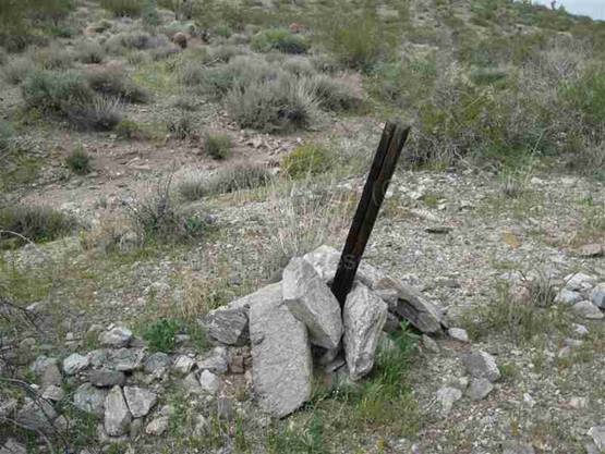
Old claim stake.
Modern stakes are PVC pipe Old loading
dock for mine with Pit below
A
personal account by Cal and Jo Callender, “History of Calevan Uno Mine As We
Knew It”, c.1981, touches on the process of mine development at Gold
Basin. Briefly, a USGS geologist named
Dr. Phil Blacet had found an old mine about 1970, probably the “Old Harmonica
Mine” first prospected in the 1870s by Woody Harmon. The geologist had
descended a shaft 50 feet where he found two large ore buckets and “associated
dead rattlesnakes, rabbits, owls, etc.” He returned to the surface and tied a
rope to his vehicle bumper and descended a 75 foot shaft, returning with an old
bucket. The Callenders filed a claim on the old mine, which had brown,
pencil-shaped vanadinite crystals on tunnel walls. They eventually found
records of a claim filed on Feb.22, 1881 by E.P. and J.B. Crooker and Thomas Burke, showing much
interest in this mine. By 1903 this mine was owned by R.G. Patterson, owner of
Patterson's Well. Others owned the mine in the 1930s. The new mine owners, the
Callenders, found evidence of an early arrastra in the creek bed below the mine
site, possibly before Patterson began working the mine.
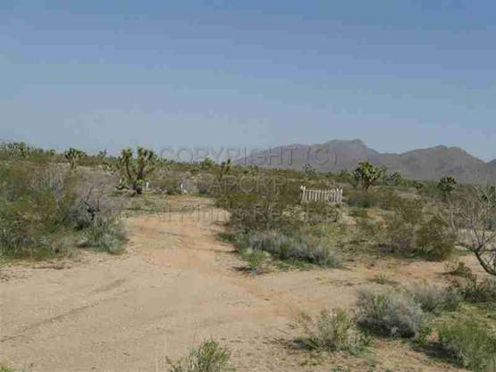
Here's
a map showing the location of the Burnt Mill, Gold Basin Cemetery, and Gold
Basin Mining Camp. Notes for each number on the map tell more details
about each site, plus Patterson well.
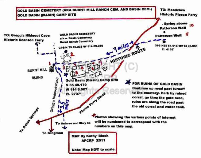
Map of Gold Basin Cemetery, Gold Basin Camp Site, Burnt Mill, Patterson
Well.
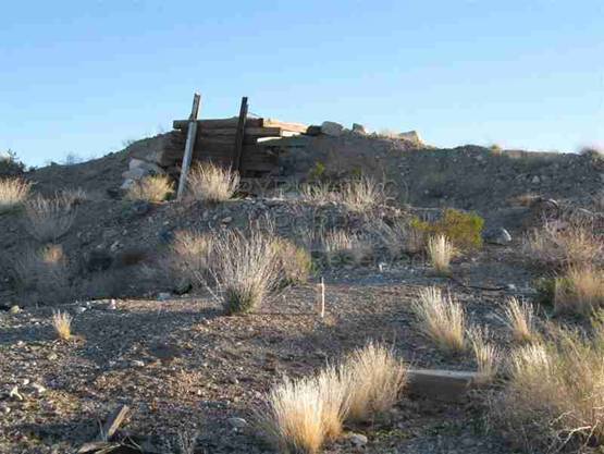
#1.
Burnt Mill. The
ruins of Burnt Mill are located on the left- hand side of Gregg's Hideout Road,
about 3.5 miles north on Gregg's Hideout Road,
from Pierce Ferry Road, about 100 yards before the main road makes a 90
degree left turn, and a sign with an arrow “To Gregg's Hideout” can be seen.
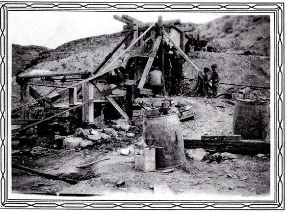
Burnt
Mill was first called the OK Mill (processing ore from the OK Mine described
earlier), then the Gold Basin Mill. It burned down twice, once in 1892, then
again in 1906. It had opened as a five-stamp mill to process the ore from the
Eldorado, OK, and other Gold Basin mines. One source states it had ten stamps
and a cyanide plant until 1906. It was not rebuilt after the second fire. It
operated on water piped from springs in the Grand Wash Cliffs, 7 miles farther
NE. Apparently, according to the history by the Callenders, Robert G.
Patterson, who operated Patterson's Well, and had a mine near the mill, would
have passed Burnt Mill on the way to his own arrastra. He provided water to
Burnt Mill for $3.00 a barrel while the mill was in operation. He may have been
involved with building Burnt Mill originally in 1886. He may have found it
cheaper to process his own ore, using an arrastra, and his own water.
A
history written in the l930's by Mohave County Historian Mamie Musser stated:
“On Hualapai Wash about 60 miles from Kingman is the wreck of the old O.K.
Mill, which burned down. In years gone by the ores from the O.K. Mine and
several gold bearing ledges were run through this mill. Since its burning, no
mining worthy of mention has been done in this district. Word has come that the
mill will be rebuilt, which causes rejoicing among the prospectors.” (It wasn't
rebuilt after the second fire in 1906.) (Courtesy
Mohave Museum of History and Arts.)
The
ruins of Burnt Mill still stand, and below are remains of cyanide tanks, and a
wash filled with pieces of tin roofing (possibly from a later date). Although
there was supposed to be an arrastra there, we did not find evidence of one.
Historic mill at Scanlon Springs
at Wallapai Wash.
(Note this wash is also spelled
Hualapai.)
It's similar to Burnt Mill.
(Photo courtesy Mohave Museum of History and Arts.)
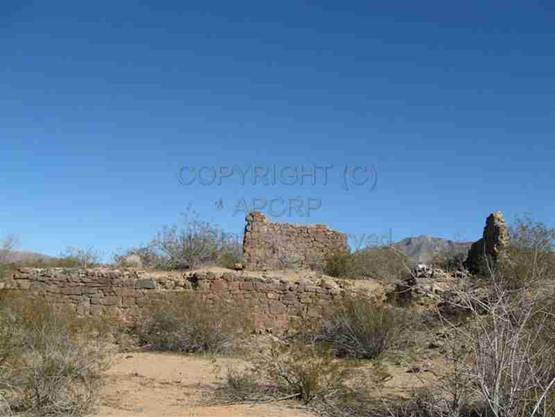
Ruins of Burnt Mill now
#2.
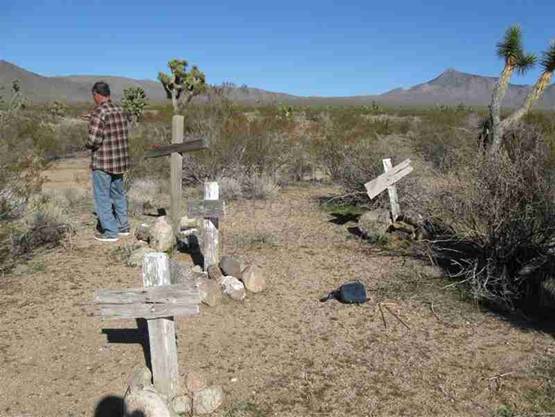
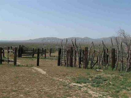
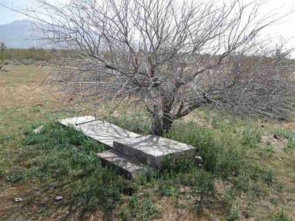
Gold Basin Cemetery, a.k.a. Basin Cemetery, Burnt Mill Ranch Cemetery. This forlorn, abandoned cemetery
consists of 4 single wooden crosses and one burial of a man and woman in a
grave enclosed by a wooden picket fence. At one time a group, the Mohave
Pioneer Women, may have painted the crosses and fence as a project, but no
record exists, and at present the wood on the crosses and fence has almost no white
paint remaining. Weeds grow freely and cattle trails traverse the area. To
visit this cemetery, cross Gregg's Hideout Road directly across from Burnt
Mill. Follow the dirt track to the left of the old corral a short distance to a
leftward spur. Take the spur about 100 feet to the cemetery.
I was
unable to find any decisive records of burials in Gold Basin Cemetery. One of
the incomplete Death Certificates, recopied in the 1930s from earlier records,
was for James Crawford, who lived at Gold Basin. He died Aug.28, 1905, at age 66 years, 4
months, 25 days. He was a single white male from Girvan, Scotland. However, in
an obituary he was one of the “old time miners” and was brought in from Gold
Basin suffering from pneumonia. He died during the night and was buried the
following day in the Pioneer Cemetery in Kingman. His obituary stated that
“Deceased was well known and liked by the people of Kingman and his death is
regretted by everybody.”
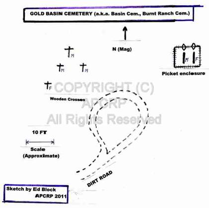
Sketch
of Gold Basin Cemetery
|
|
|
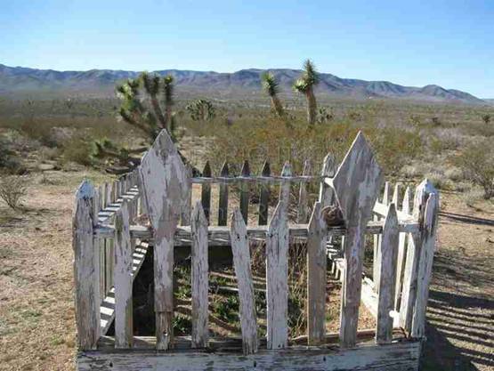
Two in this grave, male
on left, female on right Four crosses, female to right
Dirt road to cemetery – Some grave markers are visible
#3
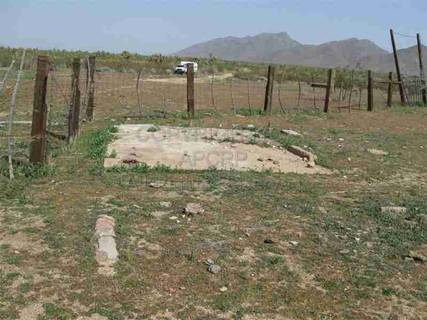
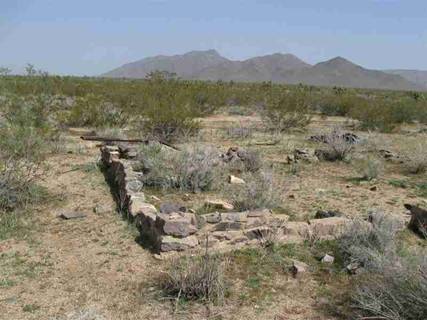
.Gold Basin (Basin) Mining Camp Site ruins. These ruins, which consist of stone foundations,
steps to nowhere, and concrete slabs, are located across the road from which
the cemetery is reached. Go thru a gate opening in the abandoned corral to your
right. They adjoin the corral along its eastern edge.
Gold
Basin (Basin) was established in the 1870s in the mining area east of White
Hills. Conditions were harsh. There were no close sources of water, timber, or
supplies. The area never developed to the level envisioned by the promoters and
was abandoned in the late 1890s. A post office operated there from Sept. 20,
1890 to Jan.4, 1894. The area was re-established as “Basin” in 1903. The post
office reopened on March 17, 1904, and finally closed on June 15, 1907.
According to Suzann Newell, who wrote a booklet on the Meadview area history, “Gold
Basin was a small grouping of shanties and tents for the miners and mill
workers of the area. Mike Scanlon, owner-operator of the Scanlon Ferry opened
the post office in Gold Basin in Sept. 1890.” (E-mail from Suzann Newell.)
(More on Scanlon later.)
There
were many mines in the area around Gold Basin, but none that were really big
producers. Since Gold Basin was 30 miles from the nearest water and shipping
lines, fuel for the mill and water were scarce. Eventually, the mines could not
support Gold Basin any longer and the town disappeared.
Here
are some of the ruins of Gold Basin. The numbers refer to the map (Insert 5) of
Gold Basin (Basin) Camp Site.
|
Figure 3. Water tank, Note ruins in
foreground |
Figure 4. Concrete square inside
abandoned corral |
|
Figure5. Concrete circle, possibly
base of water tank |
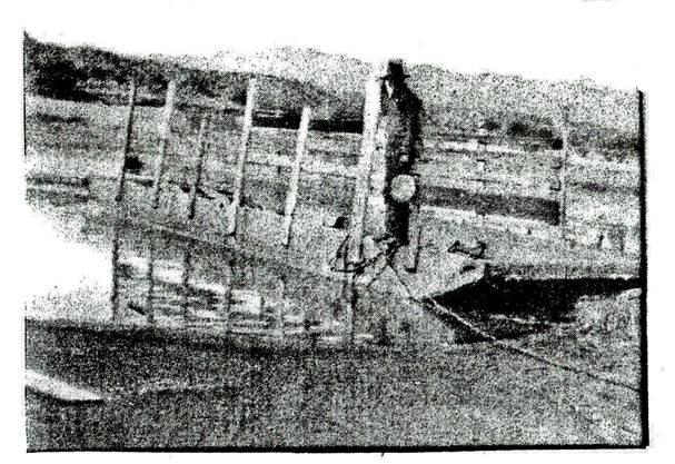
Figure 6. Broken gates of corral
with poles lashed together |
|
Figure
7. Steps to nowhere now resting under
a tree |
Figure
8. Square stone foundation |
|
Figure
9. Stone foundation with steps |
|
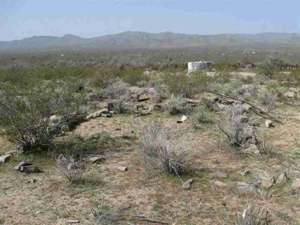

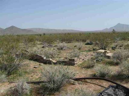
There
are several other stone foundations not shown in these photos.
A
question about the Burnt Mill Ranch was partly answered by looking at
the ruins. Maps, such as a 1960 USGS Garnet Mtn. Quad. map, show Burnt
Mill Ranch at the site of Gold Basin (which isn't mentioned).The fact that some
of the corral is built over the concrete circle and encloses some of the
foundation ruins, suggests the Burnt Mill Ranch was built after the decline or
disappearance of Gold Basin. I could find no information on this ranch. The
corral, bullet-riddled water tank, and a few tumble down buildings near the
ruins suggest the ranch itself is abandoned. Though there are fresh cattle
tracks and droppings in the area near the cemetery, Burnt Mill, and the general
area of the stone foundations, cattle could come from other ranches. We have
seen cattle at a man-made reservoir about 2 miles east towards Pierce Ferry
Road, and one instance of riders on horses rounding up cattle there.
#10.
Spring Above Patterson Well.
This
photo shows the probable source of water for historic Patterson Well. It is about ¼ mile east or above the present
site identified as Patterson Well. Water comes from the nearby Garnet
Mountains, emerging out of the volcanic strata. A system of old rusted iron
pipes led from the spring down to the tank at Patterson Well, paralleled by a
second, more modern PVC pipe. We were able to follow the pipes to the spring,
as they were visible beside the rough access track. Note the water spouting out
from the pipe. There's a dry round water tank below this that was probably once
used to water cattle.
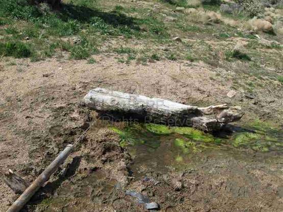
Spring above
Patterson Well
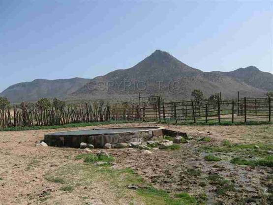
Reference 11.
Patterson Well
There's
a cattle watering tank inside a corral, with goldfish in it to eat algae and mosquitoes.
It is probably filled by water carried in pipes from the spring above.
Historically there was said to be an arrastra at Patterson Well that Patterson
used to grind ore from his own mine. We were unable to definitely locate the
arrastra, though we found stacked flat stones below the water tank, and a large
cleared area.
The
area map shows a road, now a 4x4 track, from Burnt Mill, across Pierce Ferry
Road, to Patterson Well, a distance of approximately 7 miles. It was probably the route he used to haul
water and ore back and forth. To reach the Well, drive towards Meadview on
Pierce Ferry Road. About 10 miles south of town, take the well-labeled Diamond
Bar Road that goes to the Skywalk. Just before mile post 1, turn right onto a
graded dirt road. Continue on this road about .8 miles. You will see the corral
on your right, which surrounds the water tank. We were trying to decide if this
tank is the well when a rancher stopped. When asked where Patterson Well is, he
decisively pointed to the tank, saying it was fed by a spring ¼ mile above.
Patterson
well, on a summit between Wallapai Wash and historic Tap Duncan's ranch, was
the site in the early days (1860-61) of a Pony Express a station. It consisted
of a saloon, post office, and the Pony Express station. Here the riders changed
horses. The end of the route was Pierce's Ferry to the north, where the mail
was exchanged and from there the riders returned to Patterson's Well, and then
on to the railroad and Prescott.
Patterson
Well was on the Grass Springs Ranch (Diamond Bar Ranch) owned by rancher and
miner Robert G. Patterson. He started a mill there to process ore from his many
mines, including copper ore found at the head of nearby Grape Vine Springs. He
had ownership or part ownership of the OK mine, the Excelsior, the Golden Rule
and the Cyclopic.
Robert
G. Patterson appears in the 1880 U.S. Census. He was born in 1832 in Vermont
and was 48 years old at the time. He was listed as being a single miner, living
at “Mountain Springs Station.” A “widow” named Julia C. Sanders, also age 48,
born in 1832, from Maryland, lived in the household as “other” and was “keeping
house” as an occupation. Was she a relative who came to live with him after her
husband died? A Dec. 5, 1903 news
article noted that he “came in from San Diego, California, and will leave in a
few days for Gold Basin, where he is interested in mining property. He is
looking hale and hearty and states that he is in better health than for years
past.” Patterson made regular trips from San Diego, where he'd moved, and
probably died in San Diego.
Historic Scanlon Ferry and
Gregg's Hideout Cove.
(Arrow upper left corner of Gold
Basin Area map.)
Ten
miles past the site of Gold Basin mining camp, following Gregg's Hideout Road
to a cove on the present day Lake Mead, was Scanlon's Ferry, (Somehow the name
“Scanlan” became “Scanlon”). It was an important ferry service to bring people
and goods across the Colorado at a point where the mouth of the Wallapai
(Hualapai) Wash entered the river. Gold Basin camp and Burnt Mill are above
this wash, which veers slightly NW and leads down to the Colorado River. According to the Mohave County Miner,
Jan.21, 1883, Mike Scanlon and A.J. Longstreet were working on fixing up their
ferry across the Colorado. Then, in 1888, an assessment of $375 was paid to Mohave
County for one ferry boat, one horse, tools, etc. On Dec. 5, 1891, Tom Gregg
took over this ferry and renamed it for himself. Some sources suggest Gregg was
hiding out from the law; hence the cove where the ferry was docked became
“Gregg's Hideout”. There is some historical controversy over whether Scanlan
took over an early ferry located two miles north of Scanlon Ferry and moved it
to Hualapai Wash. Nothing remains of the site, which is buried under Lake Mead.
Mike
Scanlan died January 31, 1912, at age 63. He was born in 1849 in Ireland, and
died in Chloride, though he lived in Kingman. The funeral was held in Chloride
because that's where the Elk's Lodge that paid for the funeral was located at
the time. He was buried in the Old
Pioneer Cemetery in Kingman and later transferred to Mountain View Cemetery in
Kingman.
There
is no record of the death of Tom Gregg (also spelled Grigg). Some of the family
is buried, though, in Hackberry Cemetery.
Historic Gregg's Ferry, 1923
Photo courtesy Mohave Museum of
History and Arts, Kingman, AZ
Meteorites.
Gold
Basin is famous for valuable meteorites as well as gold. The unique Gold Basin
meteorite exploded over more than 130 square kilometers of Mohave County in northwest
Arizona at the end of the last ice age, when an asteroid, probably from a body
that orbited between Mars and Jupiter, for about 4.56 billion years, hit
Earth's upper atmosphere with energy of between 10 to 1,000 tons of
TNT! The field was first discovered in
1995 by a retired civil engineering professor. He was prospecting for gold and
he and members of a gold prospecting club gathered about 140 pieces of the
meteorite! He said that collecting fragments of meteorites that fell to Earth
20,000 years ago “is every bit as exciting as searching for gold.” The
fragments range in size from a peanut to a 3 pound softball, and are found in
an area roughly 10 miles long and 5 miles wide. A collector has to be careful
not to metal detect within the boundaries of Lake Mead National Recreation
Area. People have had equipment and vehicles confiscated and received heavy
fines. These fragments are classified as chondrites, with some having unique
fresh-appearing almost complete black fusion crusts. The Gold Basin meteorites
bring the number of officially approved types in Arizona to 31! We have
searched some, but have not found any yet.
In
conclusion, Gold Basin has a long history of gold prospecting, an early mining
camp, a cemetery, a mill, ranches, and wells. At present, prospecting for gold
and meteorites continues.
The
author wishes to thank Kay Ellermann of Mohave Museum of History and Arts in
Kingman for her continuing support and interest in this write-up. She supplied
many invaluable maps, photos, and news articles from the important historical
library in Kingman. Kudos to Neal Du
Shane for reviewing and revising the maps and for his useful comments and
suggestions. Finally, Ed, my husband, carefully edited this write-up. Any
errors of interpretation of materials are my own.
American Pioneer
& Cemetery Research
Project
Internet Presentation
Version 033011
WebMaster: Neal Du Shane
Copyright ©2011 Neal Du
Shane
All rights reserved. Information contained within this
website may be used
for personal family history purposes, but not for financial profit of any kind.
All contents of this website are willed to the American Pioneer & Cemetery
Research Project (APCRP).