HOME | BOOSTER | CEMETERIES | EDUCATION
| GHOST TOWNS
| HEADSTONE
MINOTTO
| PICTURES
| ROADS
| JACK SWILLING
| TEN DAY TRAMPS
Presentation
Version 090707
Arrastre
and Grave Site in Slim
By: Allan G. Hall
TABLE OF CONTENTS
(Click on BLUE text below to go directly to subject)
Historical and Physical Context.
Physical Context of the Arrastre and Cemetery
Survey Techniques Used at the Arrastre
Introduction
If you are not
already familiar with the Monte Cristo and Black Rock Mines near
At the end of this
article you will see map and coordinate data that will aid you in locating the
arrastre and cemetery in
If interested, you
can also read some “high level” information about the “Arrastre” site by
accessing www.wickenburg-az.com, where I have posted some early
findings. The two articles are: “Hard
Way to Make a Living,” and “Hiking Through Legend & History in Middle Slim Jim Creek.”
Historical and Physical Context
The historical
context of any pioneer cemetery is important.
If pioneer settlers died as the result of an encounter with Apaches,
that provides important historical context.
If a miner died from an explosion or cave-in, or in a gun fight, that is
equally important knowledge. In this
case, we have no documented information that can guide us in determining who is
interred at this cemetery, or what led to their deaths. Instead, we are limited to the physical
evidence of the grave sites and the limited historical information about the
mines and trails that existed in the area in the late 1800’s and early 20th
Century.
The arrastre and
cemetery are located just west of the confluence of
The first map
produced by the USGS of this area (1885
The differences
between the 1885 and 1904 maps become important from a research perspective -
particularly with regard to the arrastre and cemetery. The “absence” of a trail on the 1885 map does
not mean it was not there; it may only mean that it was not documented. In contrast, the “presence” of these trails
on the 1904 map (surveyed in 1902-03) confirms that mining-supply routes
existed prior to 1902.
Why is this
important? The ore veins of Black Rock
Mine were not discovered until 1902 and this mine did not commence operation
until 1906. In other words, in 1902 it
was nothing more than a series of claims.
By 1906 it was nothing more than a “prospect” and serious development of
the ore veins did not begin until some time later. Consequently, the Black Rock Mine does not appear
on the 1904 map even though there were important trails in the area.
Similarly, the
Monte Cristo Mine was a more or less “hidden” operation in the years leading up
to 1909. A vein of very rich horn silver
was apparently discovered and mined by Mexican nationals over a number of years
prior to 1904, possibly dating back to the 1870’s. In any case, they made efforts to disguise
their operations and to conceal the entrance to the silver vein. The original miners were eventually run off
by claim jumpers. It was not until 1909
that Frank Crampton rediscovered the carefully hidden ore vein. (See Reference 1)
As you hike around
the arrastre area you will quickly confirm that it could not be seen from the
Monte Cristo or Black Rock Mines, nor was it visible from the very old pack
trails that lead in an eastward direction over the mountain toward the Gold Bar
Mine. This would seem to indicate that
the arrastre was as well hidden from view as the entrance to the silver vein at
the Monte Cristo – perhaps for the same reason.
Neal Du Shane and
I originally named this cemetery site “Black Rock 1” because of its proximity
to the Black Rock Mine and a trail (probably more modern) that connects these
two locations in a rough way. However,
given the historical context that I have provided in the above paragraphs, I am
inclined to drop the term “Black Rock” and simply identify this site as “Slim
Jim Creek Arrastre & Cemetery”. The
reasons for this will become more apparent as the article proceeds.
Physical Context of the Arrastre and
Cemetery
The
arrastre/cemetery is located on the north side of
The area is rather
densely covered with mesquite, Palo Verde and other desert vegetation. In fact, it has been necessary to do a rather
substantial amount of clearing to remove brush and prune overhanging tree limbs
(mostly dead), to enable easier movement on the terrace.
The rock wall
forms a terrace that is approximately 46 feet in length with an average depth
of about 14 feet. On the east end of the
terrace (nearest to the confluence of
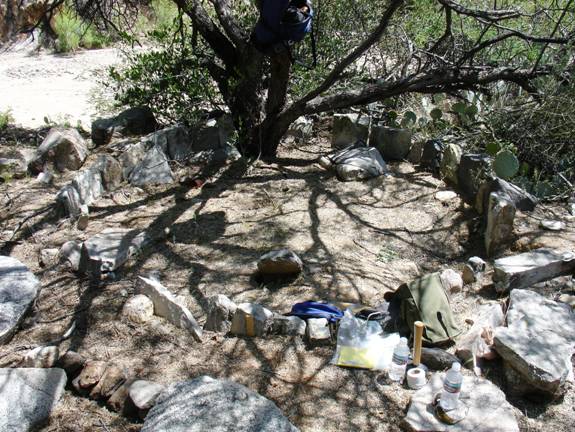
Photo #1
“The Arrastre”
Arrastres were important
in early mining days for the pulverizing and amalgamation of gold and silver
ore. This arrastre measures 112” by
108”, so it is reasonably close to a circular dimension. Its size suggests that a single drag stone
was used to crush the ore charge.
The photo shows an
outer ring of “wall” stones that is nearly intact. Just above the bottom of the outer ring
(above the blue hip pack) there is a single stone that leans sharply toward the
viewer in the center of the photo. This
is the only remaining stone of the “inner” ring of the arrastre. The width between the “inner” and “outer”
rings matches very closely to the width of the drag stones that are found at
this site. The two “grayish” granite
rocks on the lower right side of the photo (to the right of the canvas bag) are
“floor” stones that have been removed from the arrastre. The ore charge would have been poured on top
of these floor stones; then the drag stone would have been pulled over the ore
to pulverize it before initiating the amalgamation process. Beyond the
There is no
question that the terrace wall is the reason why the arrastre and graves have
survived to present time. Otherwise,
heavy storm runoff through the creek would probably have destroyed any evidence
of this site long ago. The cemetery to
the west of the arrastre terrace has not fared the ravages of
So, what’s wrong
with this photo? For starters, the
arrastre has been partially disassembled.
The interior ring is virtually gone and the outer ring is missing
several stones! Furthermore, there are a
number of floor stones that are sitting outside of the outer ring of the
arrastre.
I can’t imagine
that anyone would have cannibalized a functioning arrastre for grave stones
while it was providing value to the miners - that just doesn’t make economic
sense. So, there are two plausible
explanations: The arrastre eventually
served no economic or operational value after more efficient techniques became
available or, the arrastre was abandoned without prior intent. A more speculative way of saying this would
be as follows: The arrastre could have
been abandoned when the Mexican miners were run off or; it was abandoned when
the Mexican miners found a more efficient way to process the silver. For example, they may have started
transporting the high grade ore to a nearby mill site via pack train.
In any case, the
stones from the arrastre were eventually scavenged for grave material as you
will see in the following photos.
Without historical documentation, there is virtually no way to determine
how long the arrastre was in operation, or when that operation actually began.
Incidentally, with
a bit of elevation you can actually see an old trail that leads down the east
side of
The Graves at the Arrastre
In photo #2 you
will see four graves. Each is denoted
with a “red” survey flag. The headstones
are aligned on a south to north axis, so the headstones are on the south side
of the terrace. Each red flag marks the
centerline of the axis of burial. Of the
remaining four graves, two share the south to north axis and two have an
east-west axis. This curious alignment
seems to have been made to maximize space for burials and probably has no other
significance.
On the extreme
left side of this photo is the terrace rock wall that rises from 18” to 24” in
height. This formed the front edge of
the 46’ X 14’ terrace area. Each of the
four headstones that you see on the left in this photo was extracted from the
arrastre and they appear to have been drag stones. Each stone has a characteristic hole that was
drilled into the leading edge of the rock – indicating that it was pulled
around the arrastre to pulverize the ore.
Notice in the
foreground of the photo that there is metal debris. There is a hillside to the right of the photo
and there is strong evidence of a settlement up above (metal debris, nails and
some wood). It is possible that these
old cans “floated” down the hillside during decades of repeated runoff, but I
cannot verify this. I can visualize a
piece of light metal being carried by heavy rains in a down-slope direction. Additional discussion about the settlement
above this site will be provided in a future article.
Toward the right
edge of the photo (generally in line with the third grave) you will see another
red flag. It is partially hidden behind
some brush and cactus. This flag designates
the location of another male grave on the terrace (east-west axis).
If you look at the
area near the top where the
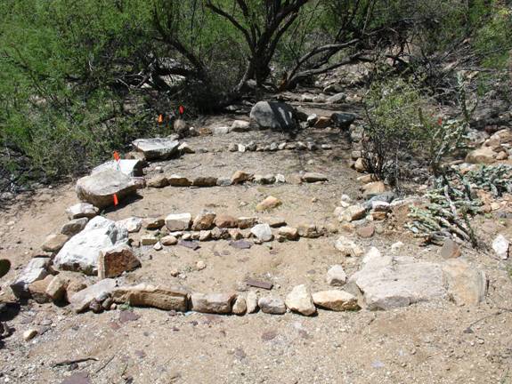
Photo #2
“Main Grave Cluster on Terrace”
All of the graves
at this site appear to be male adult or, in some cases, possibly male
juvenile. I have not yet identified any
infant graves. Photo #3 shows a male
grave that is immediately north of the arrastre. I have designated this as Male Grave #1, and
it is most likely a juvenile. To the
right in this photo you can see the outer ring of the arrastre. There are four interesting features to point
out in to photo:
First, the headstone was extracted from the
floor of the arrastre. Close examination
shows a circular grove pattern in the stone, indicating that the drag stones
and ore were ground in a circular pattern over this floor stone.
Second, the large
rock on the right side of the grave is clearly a drag stone. You can easily see the “bore hole” on the
leading edge of the rock.
Third, slightly
above and right of the headstone, there is another drag rock that was used in
the arrastre. The “bore hole” is on the
opposite site of the rock.
Fourth, with
careful examination you can see a metal nail (pin) directly beneath the red
flag at the grave. I have established a
procedure of inserting a pin in the centerline of the grave axis to denote the
grave. I use 10 inch or 12 inch pins
(available at most hardware stores and Home Depot) to outline the perimeter and
center line of all graves. This helps in
the early stages of site survey.
Above and left of
the headstone there is a path that I have cleared to reach the flat area above
the arrastre. This area contains a
settlement and up to two dozen graves that we are still researching.
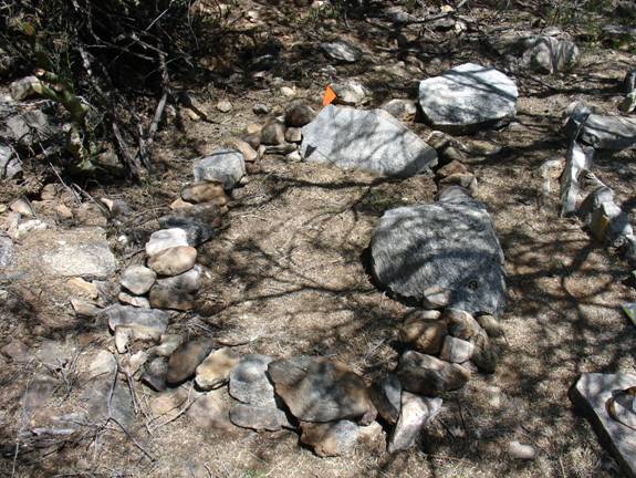
Photo #3
“Male Grave – North Edge of Arrastre”
In Photo #4 you
will see another male grave that is just west of the arrastre. There are a number of features about this
grave that are worth mentioning.
First, the headstone was also extracted from the floor of the
arrastre. There are strong circular
grooved patterns on the stone.
Second, the red flag points to another metal pin that indicates the
centerline of the grave.
Third, this grave is most likely an adult male – the length is
close to five feet, which would not be uncommon for the 1870-1910 era.
Fourth, the “vacant” space to the right (west) of this grave may
actually contain another grave.
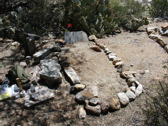
Photo #4
“Male Grave West of Arrastre”
In photo #5 you
will see a different visual angle of what I call the “main cluster” of graves
at this site.
Notice first that
there are four “headstones” that cover what appear to be three graves. Dowsing strongly indicates there is a grave
to the right of this photo. I suspect
that the headstone placements have been somewhat disturbed over the decades
following these burials. Considering the
weight of the stones, it is unlikely that cattle or other wildlife could
account for this movement. So, it is not
unreasonable to believe that human disturbance has played a role in this odd
alignment.
Notice on the left
grave that there is a metal pin near the center line of the headstone. Again, this depicts the center axis of the
grave. The edge of the rock wall that
forms the terrace is beyond the headstones.
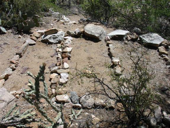
Photo #5
“Main Cluster Alignment”
Except for minor amounts
of metal debris, the arrastre-cemetery area is remarkably clean and
undisturbed, and there are no signs that cattle, deer or javelina have used the
terrace for shade or cover.
Making Sense of a Mystery
It was not
uncommon for a miner to construct an arrastre for the purpose of establishing
the initial value of an ore vein, and this might be tested from time to time to
determine if the vein was beginning to yield more or less ore. However, in the major gold and silver mining
districts of
Judging from the
number of drag stones and deeply grooved floor and ring stones that have been
found in the vicinity of the arrastre, the operations at this site must have
occurred over a lengthy period of time.
In addition to the arrastre stones that were used as grave material on
the terrace, we have found numerous stone artifacts above this site, where
there is evidence of a settlement and additional graves. In this case, “quantity of stone” equates to
“time of operation.”
After what appears
to have been a lengthy period of operation, the arrastre in
I can only
speculate on the following statements, so please do not take them as historical
fact. I can offer no documentation that
supports this hypothesis. Sadly, if
there ever was any documentation of this cemetery, it has not survived to the
present time.
Scenario
One
The cemetery at
the terrace could have been used by the Mexican miners at the Monte Cristo
after they stopped using the arrastre.
Considering the span of years of this silver mining operation, it is
plausible that a number of deaths could have occurred due to accidents, health
issues, or hostile confrontations. It is
also possible that some of these miners (and their families) could have lived
in the small settlement above the arrastre.
Scenario Two
Some (or all) of
the graves that are above the arrastre are Mexican miners and/or their
family members. There was a definite
settlement here and there are approximately two dozen graves that we have found
thus far. If the arrastre had a long
term use, burials would have more than likely occurred at this upper location
during the period before the miners were run off.
Scenario Three
The burials in the
arrastre terrace are individuals who worked at the Black Rock Mine after 1906,
and may possibly include individuals who died while working at the Monte Cristo
Mine after 1909. Although there are two
cemeteries at the Black Rock Mine, I have never found any evidence of graves at
the Monte Cristo, which seems curious.
The Monte Cristo probably operated more than twenty-five years longer
than the Black Rock and its main shaft was 1100 feet deep, with more than two
miles of drifts and crosscuts.
Considering the inherent danger of such activity, it is rather difficult
to believe there were no fatalities.
There is no real
way to know. The fact is, there was an
arrastre and there are graves collocated on this site. The fact is, it
would take only fifteen to twenty minutes to walk from the Monte Cristo Mine to
this location. It also takes only about
fifteen to twenty minutes to walk the distance from the arrastre to the Black
Rock Mine. If these graves are related
to the Black Rock, then they date from 1906 to no later than 1941. On the other hand, if the cemetery is tied to
the Monte Cristo Mine, they could date to a period as early as the 1870’s. So, who knows?
I hope to complete
the survey and documentation efforts on the terrace this fall; then resume
survey work at the settlement and grave clusters on top of the hill above the arrastre.
Survey Techniques Used at the Arrastre
Clearing Brush:
As previously
mentioned, the terrace was very overgrown with brush and tree branches when we
first discovered it in March, 2007. The
only effective way to move about on the terrace was to trim back some of the
brush and limbs. Two very useful tools
came into play in this clearing effort:
a short machete and a collapsible saw.
Another handy implement is a pair of wire cutters that I used to prune
jojoba and other shrubs. These tools are
not heavy and don’t take up much space in a backpack.
Grave Marking:
Neal Du Shane and
I first dowsed the terrace in mid-March, 2007 to initially confirm the presence
of graves. Following that, I probably
invested another three trips to the site that were dedicated to continuous
dowsing of the area, as well as clearing out brush to gain access to graves on
the west end of the terrace. It was only
after I had done repeated dowsing that I really felt comfortable in establishing
perimeters for the graves. The tools that
I use for this purpose are 10” or 12” metal nails. I establish the corners of the grave and also
place a nail at the top end of the grave to mark the center line of the burial.
After the
perimeters have been established I attach a Mylar adhesive label that
identifies the grave. For example, “ARR1
Male” denotes the grave number and sex of the burial at the arrastre. These Mylar strips are very durable and
appear to hold up very well to weather and sunlight. Unlike regular plastic labels, the adhesive
bond will not separate. The device that
I use is made by “Brother” and is battery operated with a regular keyboard for
typing out the information. The Mylar
tape comes on spools. I prepare the
labels at home before going to the site.
The worst day of
work is when you hike in with several dozen nails and a small sledge
hammer. That adds a bit of weight to the
backpack and takes up a lot of space.
(Hmmm – water or nails?)
Setting Survey Grids:
In areas where the
distribution and orientation of graves is much more complex than the arrastre
site, my son and I have established a “low budget” surveying method that relies
upon simple geometry, a long tape measure and a good compass. This does require two people, since you can’t
be on both ends of the tape at the same time.
We set nail corners on 10’ X 10’ grids and connect them with sturdy
twine. This has proved to be very
beneficial for mapping and helps us understand how graves are organized. We are currently using this technique above
the arrastre where there are approximately two dozen individual and clustered
graves in a widely dispersed area. If
you are interested in learning more about this technique, please drop a note to
Neal or me. My email address is: allan.hall@mindspring.com.
How to Get There
All
coordinates are listed in 1927 North American Datum, (NAD27), which appears on
the USGS Morgan Butte Quadrangle.
1. Distance from the Wickenburg Rodeo
Grounds to the lower
2. Lower turnoff from
Turn left at 34o 03’ 54”N by 112 o
35’ 04” W - Morgan Butte Grid #4
3. Lower entrance to
Turn right at 34 o 04’ 26”N by 112 o
35’ 22”W – Morgan Butte Grid #32
Elevation is approximately 3040 ft.
4. Arrastre and grave site in
North side of creek at 34 o 04’ 16.5”N by 112
o 35’ 04.3”W – Morgan Butte Grid #33
Elevation is approximately 3161 ft.
5. “Upper” turnoff to
Turn left at 34o 04’ 12”N by 112o 34’
35”W – Morgan Butte Grid #4
Map
to Arrastre & Graves
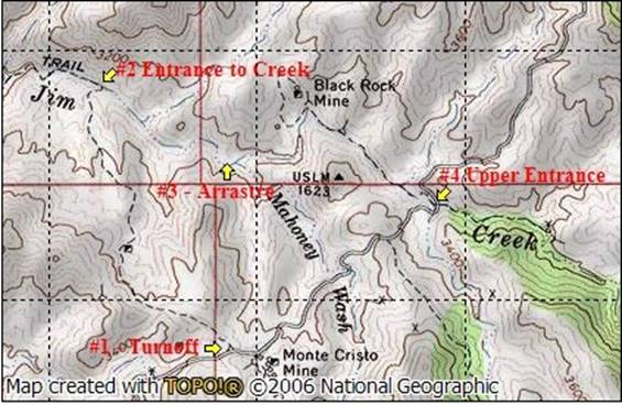
Access to the
arrastre and graves is best achieved by turning left onto the trail marked “#1”
on the map. This trail connects with
The upper
entrance, marked “#4” on the map is an alternative way to reach the
arrastre. I recommend that you park your
vehicle in the creek bed below the mine and continue on foot down
This is an active
grazing area for the Williams Ranch, which is located at the end of
There is a rough
trail that connects the Black Rock Mine to the settlement above the arrastre,
but it should not be used by vehicles.
There are several areas of very loose and soft rock that makes this
trail unsafe. Additionally, there is a
water line on this trail that runs from a spring to a watering trough for
cattle. This water line can be easily
damaged and you could loose rear traction if your tires pass over the
line. The trail is also littered with
nails in the area near the mine.
See my article
titled “Hiking Through Legend and History in
Safety Considerations
1.
The
most comfortable time of the year to visit the arrastre and grave sites is from
October through May.
2.
Expect
to see snakes from March through October – Be alert!
3.
Heavy
runoff from the upstream watershed can turn
4.
Carry
plenty of water and energy snacks and, please - pack out your trash.
Reference
1.
Deep
Enough, by Frank A. Crampton.
APCRP Internet Presentation
Version 090707
All Rights Reserved
WebMaster:
Neal Du Shane
HOME | BOOSTER | CEMETERIES | EDUCATION
| GHOST TOWNS
| HEADSTONE
MINOTTO
| PICTURES
| ROADS
| JACK SWILLING
| TEN DAY TRAMPS