HOME | BOOSTER | CEMETERIES | EDUCATION | GHOST TOWNS | HEADSTONE
MINOTTO | PICTURES | ROADS | JACK SWILLING | TEN DAY TRAMPS
American Pioneer
& Cemetery Research
Project
Internet presentation
121310-2
CERBAT
GHOST TOWN AND CEMETERY
By Kathy Block,
APCRP Historian
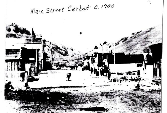
Cerbat
c.1900. Courtesy Mohave Museum of
History and Arts, Kingman
Cerbat Cemetery hides amid clumps of cactus and brush slightly southwest of the ruins of the old mining town of Cerbat. The name “Cerbat” means “Big Horn mountain sheep” in a Native American language. These sheep once were common in the area. The area and town has a turbulent history, reflected in information about some of the people buried in this cemetery! There were murders, suicides, and a hanging
The
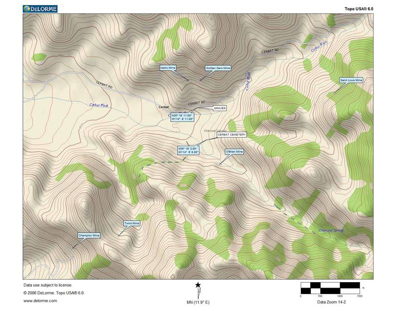
town of Cerbat had its beginnings in the Cerbat Mountains about 15 miles N.W. of Kingman,
Arizona. Gold and silver deposits were
discovered in the 1860's in this range that lies directly east of the 130-mile
long Black Mountains range. The two ranges are separated by the Sacramento
Valley, which becomes the Detrital Valley further
north between the Black Mountains and the White Hills. These valleys drain to
the northwest into southern Lake Mead near Temple Bar. The Cerbat range is
23 miles long trending slightly northwest/southeast. A series of peaks towards
the southern end of the range includes Packsaddle Mountain at 6,431 feet and Cherum Peak at 6,983 feet. The northern section is now
Mount Tipton Wilderness, with 7,148 foot high Mount Tipton.

Sign along highway
93
Photo courtesy Ed
and Kathy Block
Map by Neal Du
Shane
As
prospectors gradually settled and mined in the area, Cerbat
mining camp began to take shape in remote Cerbat
Canyon running west from the mountain range. The town was reached by a three
hundred mile steamboat trip up the Colorado River to Hardyville,
then by stage over a wagon road for thirty-eight miles. By 1872 population had grown enough that a
$6,000 dirt road was carved over the pass to bring Cerbat
residents closer to Fort Rock, Camp Hualapai, Williamson Valley, Prescott, and
civilization to the east. In 1884 the California and Arizona Stage Company, run
by James Stewart, made weekly runs to Prescott to Hardyville
via Mineral Park (to the north), and Cerbat, and to
the south of Chloride. The routes used two toll roads, the Fort Mohave and
Prescott Toll Road and the Mineral Park and Hualapai Valley Toll Road as a
direct route thru the Cerbat Mountains to Mineral
Park, then crossed Sacramento Valley, west to Union Pass, and on to Hardyville.
Post Office
Courtesy Mohave Museum of History and Arts, Kingman
Mines
began to open, including the Esmeralda, Golden Gem, and Vanderbilt. There were
enough inhabitants of Cerbat for it to be the third
Mohave County Seat in 1871, but the town lost it in 1877 to nearby Mineral
Park. (Now it is in Kingman.) From June 25, 1890 to October 24, 1902, the town
was known as “Campbell.” A post office
was opened in Cerbat on December 23, 1872. On July 12, 1877, the Mohave County Miner
printed a letter to the editor that complained that the county had contracted
with a “gentleman” to carry the mail from Aubrey to nearby Mineral Park for
$1,750 per year. The steamers had refused to carry any more and the contractor
refused to carry mail to Mineral Park,(and possibly to
Cerbat also) so “we are without mails and if we
cannot get all that is due we had better have none.” The postmaster had the
right to sort out and throw out mail, and the contractor could refuse to carry
only a part.” The writer called for an investigation! When the population
declined as the mines closed, the post office was discontinued on June 15,
1912. Although Cerbat
had cabins for about a hundred residents and was very isolated, it managed to
have two doctors and two lawyers. One of the recorded burials in the cemetery
was Amos Johnson, 1823-1888, who was a lawyer and also a Justice of the Peace
in Hackberry. Miners and their families were served by merchandise stores,
saloons and shops. Two merchants are on the cemetery roster: William Jones,
merchant, and George R. Musser, who was a manager of Taggart Mercantile. Today,
the only stone building amid crumbling foundations dug into banks and along the
wash is the old jail. Before you reach the site of Cerbat,
there is an old ore processing mill on the west side of Cerbat
Road.
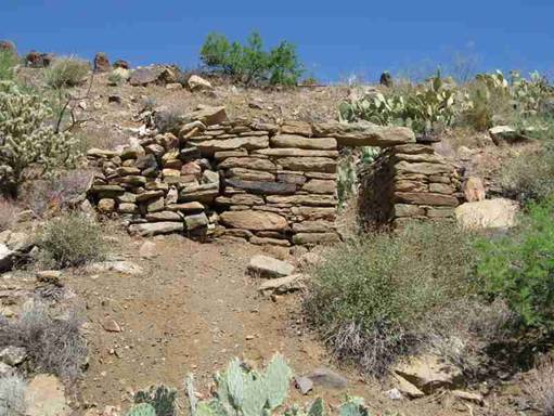
Photo by Ed Block,
Ruins of stone jail building NE of cemetery
The
mines in the Cerbat area were very productive, giving
miner’s money to spend in town. An early report from 1876 noted that there were
many mineral veins of great extent and richness in the Cerbat
Mountains. The mineral lodes weren't as large as further south, but extremely
rich. Some of the veins were argentiferous galena,
but there were also lodes of gold and silver, some as wide as ten to one
hundred feet wide. The main mine near town
was the Golden Gem. Its head-frame and shaft are on a hill just below Cerbat Canyon where the town was located. Workings included a 435 foot deep shaft with
about 1,200 feet of tunnels and stopes on the 130
foot level only. There was also a steam-powered arrastra.
The dangerous, unfenced shaft, is below the ruins of
the head-frame.
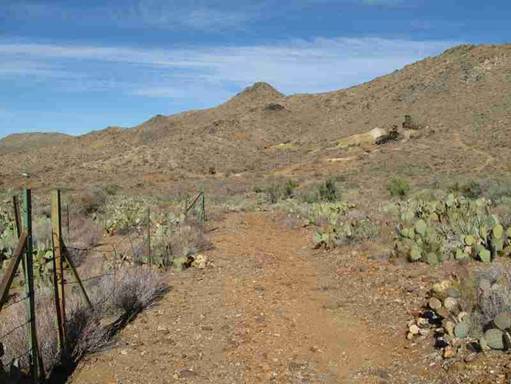
Photo by Kathy
Block
Ruins of Golden Gem
mine above turnoff to Cerbat Cemetery
Mining
continued into the twentieth century. Between 1871 and 1907, the Golden Gem
Mine produced $400,000 worth of gold, silver, lead and zinc. Other important
mines nearby that contributed to the support of Cerbat
were the Idaho, Flores, Night Hawk, and Big Bethel. A company on the Internet
offers old mining stock certificates and books for sale. Some for Cerbat included Altata Mining
Company that operated on a regular basis after the railroad to Chloride was
completed in 1899. In 1909, one could buy a $25.00, 5 year, 6 percent first
mortgage gold bond. It is now for sale for a $50 to $100 bid! A company called Grand Cons Development Co.
in Kingman had claims near Cerbat. Assays in 1908
reported 70 percent lead, 12 ounces silver, and $11.00 gold per ton. But the
company was idle in 1910. One final company to mention was the Horseshoe Gold
Mining and Milling Company. In 1907 its Esmeralda mine near Cerbat
produced $90,000 in ore consisting of pyrite and chalcopyrite with gold and
silver. One carload of concentrates shipped from the mine reportedly ran 13.42
ounces of gold and 40 ounces of silver to the ton!
Mining
was very dangerous work, sometimes associated with murder and suicide! Seven of
the known burials in Cerbat Cemetery were miners, who
often died of silicosis, usually diagnosed then as “pneumonia” or “consumption”. One miner, James Stewart, was
a laborer who was “crushed in a mine accident” in 1907 according to his DC. The stress of mining led to 2 suicides listed
on DCs among those on the roster. The DC of Juan Mannique
noted, morbidly, that he died, June 16, 1912, of a “pistol wound of the brain
inflicted by party unknown to jury.” Another miner, Manuel Villa, was murdered
in August 30, 1901. An interesting news article from the Mohave County
Miner, June 1, 1912, reads: “Archie Monroe, a well known miner of the Cerbat section was declared insane by the probate
department of the Superior Court late last week and he was taken to
Phoenix....The poor fellow had suicidal tendencies and had he not been
restrained, it is probable that he would have killed himself.” His DC shows that
he died in the Arizona State Hospital, from TB, age 45, on Dec. 29, 1914,
having been at place of death “2 years, 7 months, 2 days.” The single white
miner was buried in the “Asylum Cemetery.”
A
violent murder resulted in the hanging of Michael DeHay
in Cerbat on January 14, 1876. H.C. Hodge, a reporter for the Miner newspaper
in Prescott, interviewed the condemned man the day before he was hanged. The
story was “Confession of murderer, Michael DeHay of Cerbat, AZ, 1876” A
few highlights from this article give the flavor of those early violent times.
Michael
DeHay began by describing his early life in various
mining towns in
California, Nevada, and Arizona.
He was born in Mongoup, Sullivan County, New
York on April 10, 1830, and was 45 years old on his last day of life. In 1850
he crossed the plains to California. In
Wisconsin, on a return trip to the Midwest, he met and married Esther Hemstock in 1856.
The tragedy began in August 1875. His wife “had left my home, taking
with her my children, team and wagon and most of my household goods, and had
started towards Arizona with a Mr. Suttonfield (from
Nevada), an entire stranger to me, and who I learned had camped for a few weeks
on my ranch.” When the deserted husband
pursued the pair, “My first and great object in following was to get possession
of my dear children. I passed them at Chloride, six miles from Mineral Park,
where they had camped.” He went on to explain, “Had I then followed the
dictates of my almost crazed brain, I should have then and there stopped and
shot both the man and woman who had, as I felt, brought ruin on both myself and
children, but my better judgment prevailed and I went on to Mineral Park.”
There, he met with a lawyer, but nothing came of it. He then got a house, in Mineral
Park, went to work in a mine, and bought provisions. His wife and children
moved into his house, but things were not as they had been. He “tried by every
means to induce my wife to live with me as before and was willing to forgive
the past. To all my appeals she turned a deaf ear, continually declaring that
she never would resume her marital relations with me.”
A few
days later, he learned she was visiting Suttonfield
at his house. “This continued pressure upon my mind affected me both by day and
night.” The night he murdered his wife,
“I was completely weighed down with trouble and sorrow, and being suddenly
awakened from my troubled sleep, saw, or thought I saw, my wife standing over
me with a butcher-knife in her hand. She had been sleeping in one room in our
only bed with some of the children and I in an
adjoining room on the floor.”
Then, DeHay jumped up, “clutching my revolver, which was under my
head and rushed
after her into her room. She jumped into the bed and curled down, and I, in my
frenzy, fired at her and drew her out on to the floor. When I saw the blood,
and saw what I had done, I was horror-struck and rushed out of the house,
determined to take my own life.” He
fired his pistol into his breast twice and ran into a hay-loft. He claimed “at
the time I committed the deed, my brain seemed to be on fire and that my head
was the center of fire and maddened frenzy.”
DeHay mused that he'd never thought
of murdering his wife, but “I had at times meditated on revenge upon Suttonfield, as I felt he was the cause of all my misery.”
His final statement before he was hanged in Cerbat
was, “I make this statement with a full knowledge that my end is drawing nigh,
and that another day will launch me into eternity, where I shall meet my Maker
face to face. I forgive all who have wronged me, as I hope myself to be
forgiven by a kind and merciful God.”
I could
not find a DC for DeHay or his wife. On the LDS
genealogy site I did find a George W. Suttonfield and
his wife Sarah listed on the 1880 census as “keeping station” and “housekeeper”
at Mountain Springs Station, near Kingman.
She was from England, age 40, born in 1840 and he was from Indiana, age
54, born in 1826. Whether he is the same adulterous man can't be determined,
but he had an unusual name!
Cerbat Cemetery, the final resting
place of many who met a violent end, has 17 documented burials on the roster,
out of at least 21 “detected graves” in April 2001 when it was visited by site
stewards. Seven of these are members of the Jones family. The “patriarch” was Reese Morgan Jones. He was born on February 23, 1832, in
Glamorganshire, Wales, and died in Cerbat on February
11, 1902, of pneumonia. He was a pioneer in the area and a miner. His wife, named
Lucy Farrell, was from Lawrence, Arkansas. He had at least 3 sons and 2
daughters who were buried at Cerbat cemetery. He may
have had more children. One daughter, Lucy, was born on February 19, 1890, and
died July 10. 1892. Reese and Lucy are
the only two intact headstones in the cemetery and are placed back to back. The
markers have been invaded by cactus and are quite cracked.
|
|
|
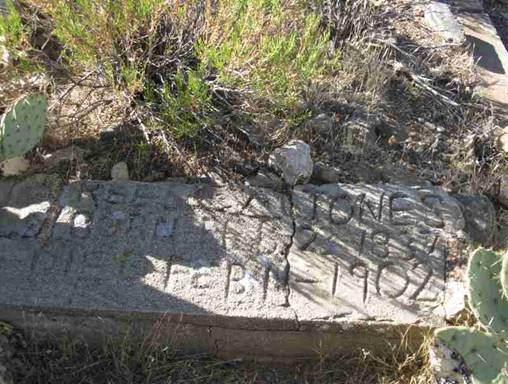

L, Reese Jones, father
of Lucy Jones - R, Lucy Jones, buried behind Reese
Photo’s courtesy
Ed and Kathy Block
One of
Reese Morgan Jones' sons was William, born in 1885. He was married to Florence
Ida Shull and had at least eight children.
The last child
recorded was born in 1929 when William was 44 years old. William was a merchant. Some of Reese's grandchildren went on to
marry into the Cornwall family, who are buried at Sandy (or Wikieup)
Cemetery. Some of the Jones family
eventually moved to Chloride. While living in Cerbat,
the large family was crowded into a stone cabin.
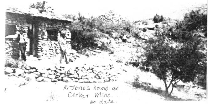
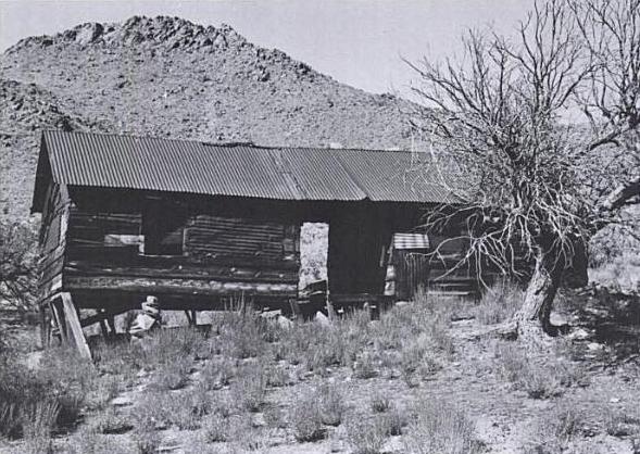
Jones home at Cerbat Mine, no date
Courtesy Mohave Museum of
History and Arts, Kingman
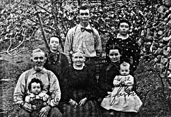
Photo
of Reese Morgan Jones family, taken possibly around 1900?
Courtesy Mohave
Museum of History and Arts, Kingman
Left to
Right: Back Row: William Jones (aka Willie) young boy; Alvah Thomas Jones; Clara Baldridge;
Morgan Jeffries Jones. Front Row: Reese Morgan Jones (the family
patriarch); Lucy Ferrell Lawrence (Lawrence is maiden name) Jones. No names of the little children. (Courtesy librarian, Mohave Museum of History and Arts.)
Cerbat cemetery is extremely
derelict. Large prickly pear cactus and catclaw bushes make research virtually impossible. Ed and I
both were picking cactus spines out of our legs for days after our visit. I was
only able to approach nine of the graves for research! A fence erected by BLM surrounds the
irregularly shaped cemetery, and a gate on one side along a washed-out track
gives access to a crude path to the graves of Reese and Lucy Jones.
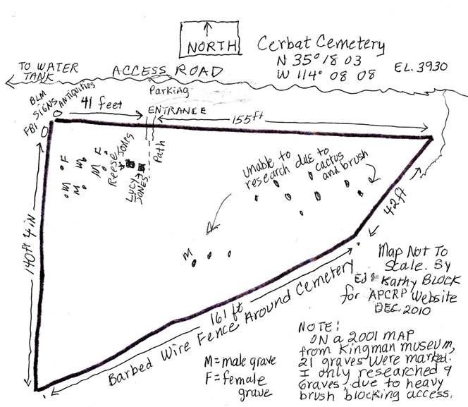
Map
of Cerbat Cemetery.
By Ed and Kathy Block
On two
sides of one corner are placed by a site steward. One reads: “FBI Investigates
Thefts of Government Property. The theft, embezzlement, illegal possession or
unlawful destruction of any property belonging to the United States Government
or being manufactured under contract for the government is a Federal violation
punishable by a maximum penalty of 10 years in prison and at a fine of $10,000.
A THEFT FROM YOUR GOVERNMENT IS A THEFT FROM YOU. NOTIFY THE FBI IMMEDIATELY OF
ANY VIOLATIONS. To contact the FBI, consult page one of your
telephone directory.”
The
other sign reads: “U.S. Department of the Interior. BUREAU OF
LAND MANAGEMENT. NOTICE. You are on Federal
lands. Cultural resources in the vicinity of this notice are fragile and
irreplaceable.” ….”Penalties prescribed by law may be up to $250,000 fine,
imprisonment, for up to six years or both. Forfeiture of vehicles and equipment
and other civil penalties also may be imposed.
Permits to excavate or remove artifacts can be issued only to qualified
persons for the purpose of furthering knowledge in the public interest.” In an
earlier contact with the site steward when I unsuccessfully tried to get
directions to Cerbat Cemetery, he was quite worried
about vandalism or grave digging (which is an Arizona Urban Legend)! As you can see in the photos, this would be
extremely difficult and unlikely!
|
|
|
|
|
|
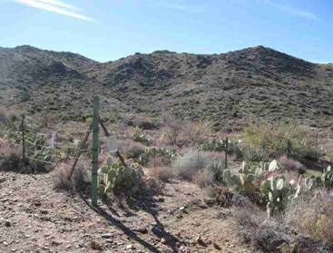
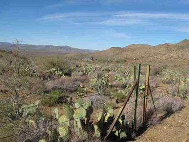
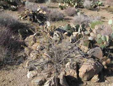
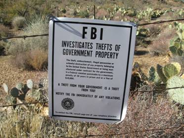
UL, Signs on
fence. UR, Fence around cemetery, showing gate, surrounding
cactus and brush.
LL, Plants like
the graves. LR, FBI sign.
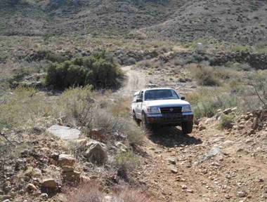
Here
are directions to Cerbat Cemetery. A high clearance
vehicle is necessary, and even 4x4, if you drive all the way to the cemetery
gate!
From
Highway 93 that goes between Kingman and Hoover Dam, turn east at Milepost 62,
where there are signs for a “Historical Marker.” The marker reads: “CERBAT. Site of Cerbat third historical Mohave
County seat, three miles from this highway in Cerbat
Mountains and in canyon of the same name. It came to existence in 1860s
as mining camp, and had mill, smelter, post-office, school, stores and saloons.
Only mine sites remain now. Mohave County Bicentennial
Commission. 1976.” Go .7 mile and go left at a fork instead of straight
ahead. Travel another .6 mile and go
right, instead of straight ahead. At a ranching/mining site, turn left. There is a faded sign on your right as you
approach the junction that says “Cerbat” with a
left-pointing arrow. Follow the increasingly rough road another 2 miles, past
an old ore processing plant on your right.
You will come to a junction below the ruins and head-frame of Golden Gem
Mine. Turn right towards a visible cattle watering tank. Unless you have an ATV
or 4x4, stop and park at the edge of a steep rocky track that goes into a wash
and walk from there. Go about 1/4 mile to the cattle watering tank, which is on
your right. Turn left immediately in
front of it on a badly washed out track.
About 150 yards ahead, on your right, is the gate that goes into Cerbat Cemetery.
|
|
|
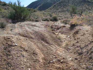
L. You may want to
walk from cattle tank. R. Road up from wash.
Cattle tank where
turn left is in background.
Photo’s courtesy
Kathy Block
On a
previous visit to unsuccessfully try to locate Cerbat
cemetery, we may have found possibly eight or nine graves at the junction below
the mine, on the southwest corner below the road. I have located no information about them.
They could have been graves of miners from the Golden Gem Mine? More research is needed. We did not attempt
further research during this visit, as a road grader had been working and
mounds of dirt were piled over part of the area.
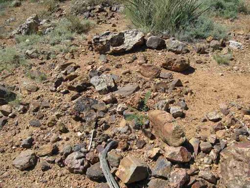
Possible graves at
junction to cattle water tank.
Photo courtesy Ed
& Kathy Block
If you
drive slightly further east on the main Cerbat Road
into the canyon, you can park and explore the stone foundations and walls that
were the town, and speculate on the lives and deaths of the isolated town of Cerbat. The road thru the pass over to the east side to the
Hualapai Valley and
Stockton Hill Road was in almost impassible condition at the time of our visit,
with the wash filled with sand, debris, and boulders. A bypass went sharply uphill to the left, but
we did not attempt it with our 4x4 Toyota pickup.
Cerbat was briefly advertised for sale
in 2007 as: “Ghost Town for sale in Cerbat, AZ.
Historic old ghost town of Cerbat, AZ. Complete with
mineral estate rights. Buildings, roads to properties, etc.
Seller wants to sell unit complete. Can be used for a new RV
resort, custom home sites, etc. Could also be used for
alluvial sand & gravel pit.” Fortunately, this million-dollar
property was “off the market” in early 2010, so access to the cemetery should
still be possible.
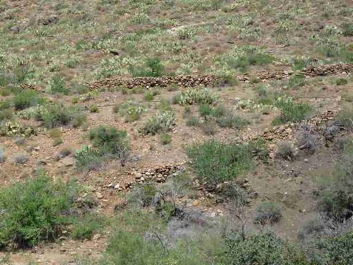
Ruins at
Cerbat
Photo Courtesy Ed & Kathy
Block
American Pioneer
& Cemetery Research
Project
Internet presentation
121310-2
WebMaster: Neal Du Shane
Copyright © 2010 Neal Du
Shane
All rights reserved. Information contained within this
website may be used
for personal family history purposes, but not for financial profit of any kind.
All contents of this website are willed to the American Pioneer & Cemetery
Research Project (APCRP).
HOME | BOOSTER | CEMETERIES | EDUCATION | GHOST TOWNS | HEADSTONE
MINOTTO | PICTURES | ROADS | JACK SWILLING | TEN DAY TRAMPS