HOME | BOOSTER | CEMETERIES | EDUCATION
| GHOST TOWNS
| HEADSTONE
MINOTTO
| PICTURES
| ROADS
| JACK SWILLING
| TEN DAY TRAMPS
American Pioneer & Cemetery Research
Project
Internet Presenation
Version 012307

Neal Du Shane
Version 012308
TABLE OF CONTENTS
COLUMBIA,
ARIZONA. 4
INTRODUCTION. 5
WARNING NOTICE. 6
HISTORY OF COLUMBIA, ARIZONA. 7
ELIZABETH LEE CHAMPIE. 9
CHARLES CHAMPIE. 10
COLUMBIA. 14
COLUMBIA CONFUSION. 14
COLUMBIA AERIAL PHOTOGRAPH. 17
SPANISH ARRASTRE. 18
ORE PROCESSING OPERATION. 19
MAP OF COLUMBIA AND AREA MINES – 2007. 20
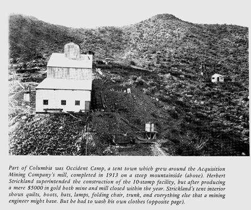
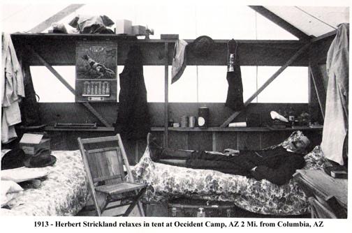
OCCIDENT CAMP. 21
JACK SWILLING KNOWN TO HAVE VISITED COLUMBIA 24
SWILLING CEMETERY. 25
COLUMBIA - GRAVES AND CEMETERIES. 26
DEATH CERTIFICATE OF COLONEL C.W. NORTH. 28
ORVILLE PERRY – DEATH CERTIFICATE. 31
T H E C O L U M B
I A M I N E S. 36
EXPLORATION OF HUMBUG MINING DISTRICT. 39
ECONOMIC GEOLOGY OF THE COLUMBIA CLAIMS. 45
DIARY. 49
COLUMBIA EXPERIENCE. 59
RODNEY “PUG” DALTON JR. REMEMBERS. 61
GEORGE WALTERS SHOT JUDGE. 61
GEORGE WALTERS SHOT BIKER. 62
NEWT WHITE. 73
TROY GILLENWATER - MEMORIES OF “CURLY” McKIBBY 76
BLACK ROCK & RED ROCK CLAIM’S. 78
CURLY’S HELICOPTER ENCOUNTER. 81
NIPPER, KIPPER AND SUSIE. 82
CURLY’S INTERMENT. 82
DOGS ADOPTED. 83
CURLY McKIBBY’S DEATH CERTIFICATE. 84
‘Curly’: introduction to the desert 85
CURLY McKIBBY PHOTOGRAPH. 86
GILLENWATER DONATES
$1,000.00 88
“ HARRY ” 89
CACHE La POUDRE. 90
CAUTION. 92
DIRECTIONS. 92
CEMETERY INFORMATION. 94
HISTORY OF CHAMPIE SCHOOL 1928-1978. 97
COLUMBIA STROLL TO. 101
“CURLY’S PLACE” 101
ACKNOWLEDGEMENT. 119
PHOTO ALBUM. 120
COLUMBIA AND CLAIMS FOR SALE. 136
INDEX. 137
SOURCES. 141
COLUMBIA, ARIZONA
Volume One
Version 121707
Copyright © 2007 by Neal Du Shane
No part of this book or Website page may be reproduced,
stored in a retrieval system or transmitted in any form or by any means, electronic,
mechanical, photocopying, recording or otherwise, without permission of the
publisher.
Published by: Neal Du
Shane, Fort Collins, CO 80525
First Edition
Published in the United States of America
Cover: This is as Columbia, Arizona
appeared in 2000. Photo was taken from the hill looking toward the north -
northwest. Photo courtesy: Kevin Hart
All buildings were
destroyed shortly there after by the BLM.
Neal Du Shane has been researching ghost towns for 40 years.
Living in Colorado has allowed him to vacation and explore in the mountains for
30 years. Neal spent the winter reading, researching and the summer physically
locating these ghost towns and mining camps. In 2002 Neal retired and became an
Arizona “Snow Bird.” Getting into the backcountry is in his blood and research
started immediately in the Southern Bradshaw Mountains. Neal has compiled and written on Countess Minotto, “Arizona’s Time Honored Legend - Jack Swilling”, Shoot Out at
Tussock Springs, Tip Top, Arizona, Humbug, Arizona, Swansea, Harrisburg and now Columbia, Arizona. In addition more than 90
pioneer cemeteries and graves have been found and recorded. This list grows
daily as we learn of these derelict locations. Neal says “If we don’t preserve
these historical museums of our heritage all information will be lost forever.”
Neal and his wife, Joyce, founded the Arizona Pioneer & Cemetery
Research Project (APCRP) in 2003 documenting, recording, restoring
pioneer cemeteries and graves in Mitchell County, Iowa and in Arizona.
Currently Neal and the APCRP team are researching and finding hard to locate
and derelict grave sites of our pioneer heritage.
Historic Arizona information is presently posted on two web
sites:
http://www.apcrp.org
http://n.j.dushane.home.comcast.net/
Please visit these sites and review the historic information
compiled by APCRP.
Figure 1.
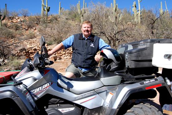
Neal at Columbia, Arizona with his 2007Can-Am Outlander Limited ATV c.
2007.
Photograph courtesy: Bruce Colbert
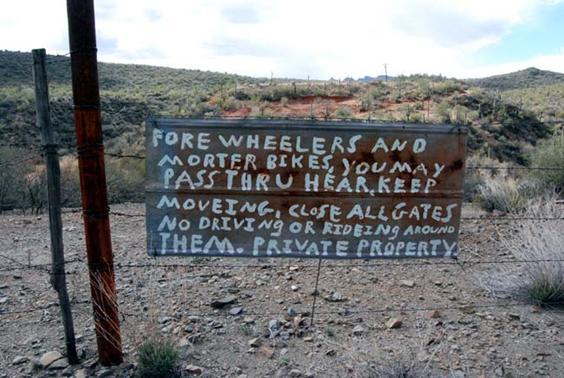
Figure 2. Columbia is Private
Property and posted. Any perceived theory on the sign painter’s ability to
spell does not diminish their ability to shoot trespassers. Photograph by:
Bruce Colbert
Quote In-part: Robert
W. Service, “The Spell of The Yukon”
I wanted
the gold, and I sought it;
I
scrabbled and mucked like a slave.
Was it
famine or scurvy – I fought it;
I hurled
my youth into a grave.
I wanted
the gold, and I got it –
Came out
with a fortune last fall, -
Yet
somehow life’s not what I thought it,
And
somehow the gold isn’t all.
There’s
gold, and it’s haunting and haunting;
It’s
luring me on as of old;
Yet it
isn’t the gold that I’m wanting
So much
as just finding the gold.
Arizona has been shaped by many cultures, inventions and
events. Native Americans, Spaniards, Mexicans and Europeans are just a few of the
cultures that have made their marks and their homes in the Grand Canyon State.
Pioneers, prospectors and miners came to this area in the
1850’s exploring the region following in the foot steps of Spanish miners.
Miners abandoned the region by 1867 giving the name “Humbug” to the creek flowing out of the mountains. Humbug is an archaic term meaning "hoax", or
"jest."
From 1882 thru 1934 there was sporadic mining in Humbug, Rockwall Gulch, Carpenter Gulch, Swilling
Gulch, and Gold Hill Mountain. There were well over a
hundred mines and claims, a few of which Dave Burns, historian and caretaker of
Humbug, knows a little bit about.
The Beacon Light Mine has an extremely interesting history.
The owner had a good mine although extremely inaccessible in Swilling
Gulch. He owned the mine,
store, saloon, whore house, and boarding house, all at the mine property.
Not much money left the area except in his pocket. After he was
done mining, he moved to Phoenix and started a Bank.
Other mines in the district were the Sidewinder that produced about 2,000 oz gold for Charlie
Champie, Mountain Chief Mine produced about 5,000 oz gold for Charlie
Champie, Little Annie Mine about 1,000 oz gold for Frank Hyde, Uncle Sam unknown amount in
silver.
Lizzie Lee Mine (Figure 3), Acquisition Mine (Figure 26), Betty Lou Mine, Top Notch Mine, Gold Spring Mine, Little Joseph Mine, Crescent Mine were all producers, but Dave doesn’t have
figures on their production. There were many more that were only prospects.
Swilling Gulch was notable as there were at least 50
different mines and prospects there.
The first mining was in the late 1870's when placer miners
worked their way up Humbug Creek and found some small lode deposits. This
started a small gold rush.
Charlie Champie showed up around 1882 and worked up at Humbug. People came and went and
mining continued until the mid 1930's.
The Little Joe mine was from the early 1930's. Newt White (Figure
26) worked there during the first phase of mining when Charlie Champie's son-in-law, Joe Stockdale, was in charge. Joe
lost the contract, however, and someone else took over. They moved to a
different spot on the vein, and did quite well.
Records from the 1870's era are almost non-existent, just stories I heard from
Newt. I don't know much about the Lizzie Lee mine near Lizzie Lee Spring, except that it had a
reputation as a good producer.
Figure 3
Lizzie Lee Mine in Swilling Gulch. Photograph courtesy: Bruce Colbert c. 2007
Charlie Champie came to the
area and developed placer mining at Humbug, Arizona then moving down stream on
Humbug Creek a
mile to a mile and a half, near the area of Columbia in
1882. Built a stone house and the Champie Mill on
a peninsula about ¾ mile north of Columbia where the Humbug Creek and trail to
Acquisition Mine turns Northeast. It is believed there is a
cemetery at this location where his baby is buried with up to 4 or 5 other
individuals buried there.
By: Dave Burns
Born on October 31, 1865 in Illinois, Lizzie Lee Champie was the daughter of
Thomas and Agnes Bridget Feeley Lee. Lizzie had married Charles Edward Champie, II, on November 16, 1882 in
Ft. McKavitt, Texas. Lizzie came with her husband
and two children to Arizona in 1886, as a 20 year old bride. They settled on a
small piece of land between Ash Creek and French Creek.
Figure 4.
Photograph Courtesy: Ann Tewksbury
Lizzie was a homemaker and rancher, Lizzie & Charles had
12 children: Bessie Bridget (Mrs. Frank) Morgan (October 7, 1883
in Ft. McKavitt); Addie U (Mrs. Marshall) Young (October 16, 1884 in Ft.
McKavitt); Charles Thomas ( November 29, 1886 in Columbia, AZ.); Mary J. (Mrs.
"Doc") Wills (February 10, 1889 in Columbia); Emma Lorien (Mrs. Thomas)
Stockdale (September 12, 1892); Joseph (April 28, 1894); Annie Lee (Mrs. Clyde) Douglas (April 24, 1896);
George Edward (January 15, 1898); Claire Elaine (Mrs. Fred) Cordes (February 7,
1900); Henry Lawton (December 2, 1902); Samuel Richard (died as an
infant); Gertrude March (Mrs. Tommy) Walker (July 1909 in Crown
King).
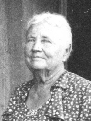
Up to and through the 1950’s Lizzie resided at the Champie
family homestead, at that time called "Champie Guest Ranch" near Castle Hot Springs. Lizzie died in Glendale, Arizona
as the Champie family matriarch, in December 1958 and she is buried in the
Champie Cemetery off Champie Ranch Road northwest of Castle Hot Springs, behind
the School House at Champie Ranch.
Current research suggests that Samuel Richard Champie the eleventh of twelve Charlie and Elizabeth
Champie’s children, was born in 1908 and would have died the same year as an
infant. Further documentation has been gained, we believe Joseph is the infant
that was stung with a scorpion in his diaper and is buried at the Champie Mill one mile north of Columbia. Joseph Champie grave has been found but the death date on the
headstone is wrong. There is no documentation of a Samuel Richard Champie being buried at the Champie Ranch Cemetery nor has the grave been found.
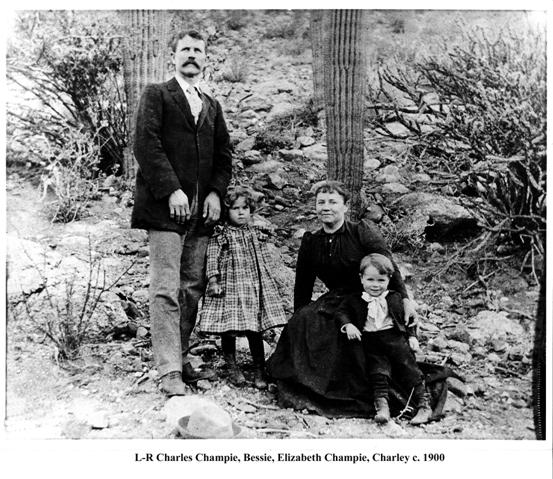
Photo Courtesy: Clairann Cordes Allan
Courtesy: Cathy
Cordes
In 1885, school teacher Charles Champie and his wife Elizabeth with their two
daughters, Bessie and Adeline, moved from San Angelo,
Texas, to Ysleta, Texas, and the next year they moved on to Arizona.
Elizabeth's mother, Bridgett Lee, and her uncle, John Lee, were already in Arizona and
had written back to Texas, urging Charles and Elizabeth to follow them and make
their fortune in the booming mining industry. They had gone to Ysleta to try
farming, but, after two difficult years there, decided to try their luck in the
new Territory. They sold most of their belongings and boarded a train that took
them as far as Ashfork, Arizona. Since the railroad was not
yet completed to Prescott, they had to make the rest of the trip by stagecoach.
After a stay in Prescott they took another stage to Tip Top, in the southern foothills of
the Bradshaw Mountains, where Bridgett and John were
waiting for them. It was a long trip and the ruggedness of the country
discouraged them, but John's tales of rich deposits of gold, just waiting to be
found, convinced them that they had made the right move. They made their home
in a small rock cabin and in a few months their third child, Charles, was born.
Charles and Elizabeth had joined the flood of pioneers that were to stake a
claim and raise their families in the rough wilderness of the Arizona Territory.
Charles' father, Charles Shampie, was born of French-Canadian
parents in 1833. He ran away from home when his parents wouldn't let him marry
the girl that he loved and enlisted in the Army in New York under the name of
Charles Champie, severing all ties with his
family. In 1852 the Army sent him to a new fort being built in Texas, Ft.
McKavett, where he met and married
Mary Elizabeth (Betty) Shellenberger in 1859. After leaving the Army he farmed for
a while and later opened a store, hauling his own supplies in from San Antonio. After he suffered a stroke
and could no longer drive the wagon to San Antonio, Betty took over, driving at
night to avoid the Indians and outlaws. Their oldest child, Charles, was born
in 1860, and they had fourteen more. The elder Charles and Betty both died in
Texas and are buried at Ft. McKavett.
Elizabeth was born in Illinois in 1865 to Irish immigrants
Tom and Bridgett Lee. They also settled at Fort McKavett
where Tom was a stone mason and Bridgett ran a hotel and boarding house. They
had ten children. Their daughter, Elizabeth, married the young school teacher,
Charles Champie, when she was only seventeen.
Two years later the young couple moved to Ysleta, south of El Paso on the Rio Grande to try farming. After months of back-breaking
work clearing the land on the Mexican border, they decided to try for a better
life in Arizona.
Tip Top
Charles and Elizabeth lived and worked in numerous mining
camps in the southern Bradshaw’s for the next several years including Columbia, Hoffman, Copperopolis and Wagoner. They had nine more children,
none with the help of a doctor except for the last, Gertrude, who was born when Elizabeth
was forty-five. After Bessie and Adeline, who were born in Texas,
their other children in order of birth were; Charles, Mary, Emma, Joseph, Anne,
George, Claire, Lawton, Samuel and Gertrude. Joseph and Samuel both died
as babies. Elizabeth became a mid-wife and nurse, traveling miles on horseback
ill daytime or night, to deliver babies or nurse a sick neighbor. Besides being
one of the few women in the country, her kind and generous nature made her a
natural nurse.
As with all miners, the Champie’s had good and bad times.
Once, they were offered $10,000 for a strike. They considered taking the money
and buying Castle Hot Springs, which was available for
$7,000, but, like true miners, decided to gamble on the strike paying off and
turned the offer down. When their own prospects weren't supporting them,
Charles took a job in the mill at Tip Top, a rough and lawless mining
camp. There were two factions in the town, those who liked or profited from a
wide-open "hell hole," and those who wanted
to make it a respectable place to live and work. The always honest and upright
Charles was elected Justice of the Peace by the "decent" faction and set out
to try to clean up the unruly camp. However, he and Elizabeth soon tired of
"city" life and returned to the Humbug Creek area and went back to working their own mines.
Their big success was the Mountain Chief mine at Columbia which they worked for years. Charles carried
the ore on horseback at night to sell in Phoenix in order to avoid the many
thieves who made a living in the area. The local stage coach was robbed several
times a month.
The Ranch on French Creek
Craving a permanent home of their own where they could raise
their children, Charles and Elizabeth homesteaded a ranch at the confluence of
French and Ash Creeks a few miles from Castle Hot Springs. They had tried to live in
Phoenix for a while when their children grew to school age, but realized that
they preferred living their own life in the country and returned to the
sun-baked Bradshaw foothills. Charles used mules to pack in lumber and pipe
from abandoned mining camps in the surrounding hills to build a house and
irrigation system. Water was piped in from the two creeks and they planted an
orchard and garden. Before long they had chickens, ducks, geese, turkeys and a
milk cow. Charles started a herd of Angora goats that grew to several thousand and, eventually,
he had to hire an extra man to watch them all. Every Sunday the bachelor
prospectors in the area were invited to the Champie ranch for Sunday supper.
Giving these men, most of whom probably lived alone, a home-cooked meal served
at a dining room table surrounded by happy children was probably the high point
of their week.
Being a former school teacher, Charles knew the value of
education and, as their children grew, he hired a school teacher to live with
them and teach the children.
Eventually, Charles built a school house near the ranch and
he and Elizabeth periodically scouted the country for school-aged children so
that there would always be enough of them to maintain a school district and
teacher. Often, children who lived some distance away were invited to live with
the Champie’s while they were attending school. The Champie School became the primary center of learning and
social activity for the residents of the southern Bradshaw’s for the next
several decades.
Charles had also purchased three Durham calves and established a small cattle herd with the
CE brand, periodically selling fresh beef to local mining
camps and towns. However, he never had much of a herd and concentrated mainly
on his goats. As he grew older he turned over the responsibility of managing
the stock to his surviving sons, all of whom grew up to be cattlemen. When all
of their children were more-or-less grown, Charles and Elizabeth tried to
escape dusty Arizona and bought a chicken ranch near Escondido, California. It was beautiful, green
country and Charles thought that his goats would thrive there. He had them
shipped out by train and turned them loose, but the goats refused to eat the
grass and nearly -starved. Charles finally gave up and shipped the goats back
to Arizona. He sold the chicken ranch, but made a nice profit because of a
granite quarry that was found on the property.
When they returned to Arizona they found that their old
ranch house had been badly damaged by intruders, so Charles hired some Mexican
artisans and built a new adobe home about a half mile up the hill from the old
one. Charles and Elizabeth moved into their new home and continued to work
their mining properties until Charles died in 1932. Elizabeth then moved in
with her daughter Claire and her husband Fred Cordes at their ranch in Bumble Bee and stayed with them until her death in 1958.
Even at eighty years of age, Elizabeth was still riding over twenty miles on
horseback to check on her mine in the mountains. After moving to the new house,
they had turned the old ranch house over to their daughter Annie and her husband Clyde Douglas. They fixed up the old place,
added a swimming pool, and opened what was probably the first family-owned
guest ranch in Arizona. Many former guests of the Castle Hot Spring’s Resort started frequenting the Champie Guest
Ranch and it became very successful. The Douglas'
sold the guest ranch in the 1940s and moved to a ranch near Whittman.
The Two Shoe Ranch
In the early 1930s, after Charles had died and Elizabeth had
moved away, Lawton and his sister Mary added some rooms and made
some changes to the newer adobe ranch house with the idea of turning it into a
guest ranch. However, this partnership did not work out and Mary and her
husband, "Doc" Wills, moved to Phoenix, and Lawton moved into the house and started his own
cattle operation. Originally, he was given the house with the idea that he
would take care of his mother, but she was more comfortable with her daughter
Claire's family and finally just stayed with them. Lawton called his ranch the Two Shoe and built it into
one of the largest and most successful cattle ranches in central Arizona, with
seventy-five sections in the desert and forty-five sections of Forest Service
permit in the Bradshaw Mountains. At any given time he had up
to seven or eight hundred head of cattle. He had some of his father’s goats at
first but got rid of most of them quickly. He loved cattle but didn't care much
for goats. He just kept a few around for fun, as ropin' goats. Occasionally,
Lawton would take some of the overflow guests from
the Champie Guest Ranch. One of his more famous
guests was the gangster John Dillinger,
who was on the run from the law at the time. An article about this unexpected
guest appeared in the local paper, but Lawton didn't have any idea who the man was while he
was staying with him. In spite of these distractions, Lawton's main concern was always
cattle. But if one of Lawton's great loves was the cattle
business, the other was rodeos.
Columbia's Post Office was established
on September 25, 1894 and discontinued July 31, 1915, concluding 21 years of
service to this mining community and surrounding area.
At its peak, Columbia was a mining camp of approximately 100 people.
Columbia had a business community comprising of:
Total production over the life span of Columbia was only about $50,000. Today that isn’t an excessive
amount of money but in that era it would have been very respectable. Expenses
could have easily exceeded production dollars however, leaving investors with
worthless holes in the ground.
Currently the mining that is being done, is by hobby miners
(not their profession) that are working in the area with a caretaker at the ore
processing site (Figure 9). Plus the community of Humbug approximately 2 miles northwest up Humbug
Creek has a resident caretaker.
Prospectors that heard
rumors of gold and silver float in the southern Bradshaw’s began working the
gulches, but found little treasure.
After the rich Tiger Mine discovery in 1870 near the headwaters of
Humbug Creek and
Bradshaw City, miners renewed their search
down Humbug Creek and found gold placers. Between 1872 and 1874
about fifty miners worked the gulches below Gold Hill, giving the area such place
names as (Jack) Swilling Gulch, (Dan) Rockwall Gulch, and (William) Carpenter Gulch.
In 1884 a store and
gold mill were built at Humbug Camp a mile above the placers and
lodes.
A decade later another
company built a mill a mile below the placers. A half dozen buildings and Columbia Post Office clustered around the mill.
Although the mines produced only $50,000 worth of gold, Columbia lingered on
until 1915 when the British financed Acquisition Mining Company ceased operations
(Figure 11).
Stone houses from the
placer mining era and adobe buildings dating from the 1880's are on the creek,
with clusters at Humbug and Columbia (Figure 13).
Over the years, there as been confusion as to the exact
location of Columbia and justifiably so. Originally there was a
community by the name of Columbia that was up on the flats on the present day
road between Humbug and Columbia. It sat on the south side of the
road after the “T” intersection leading to Humbug. Travel approximately
one-half mile and there are two graves of men held up, shot and killed for gold
they did not possess. Tragic and meaningless end to these pioneers’ lives. The
Arizona Pioneer & Cemetery Research Project (APCRP) has placed two markers at the graves of these
two gentlemen. We refer to this location as “Old Columbia” (Figure 5 & 6).
Figure 5
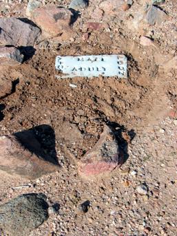
Figure 6
Old Columbia graves Figure 5
& 6
Markers placed by the Arizona Pioneer & Cemetery
Research Project (APCRP) 2006.
Photograph’s by: Neal Du Shane
Getting back to the subject at hand, that of present day
Columbia. After you have turned right at the “T”
intersection on Columbia Trail, continue northeast toward
Gold Hill Mountain until you approach a trail to your left
indicating a BLM route,
turn left and follow this route.
As you approach the Gold Hill area you will see the mining operation on the
right with holding ponds of a fairly current operation (Figure 9). In 2007,
this is the current residence of caretakers, Betty and Larry Gill. The property is owned by Mr.
and Mrs. Losee currently residing in Utah. This is not to be
confused with Columbia although it is very close and please do not
trespass on this property as it is posted and gated. (Figure 2)
Follow the BLM trail to the left and you will come to the
Humbug Creek river bottom. Turn to your right and bounce
through the creek to the east bank. Look across the creek bed and you will
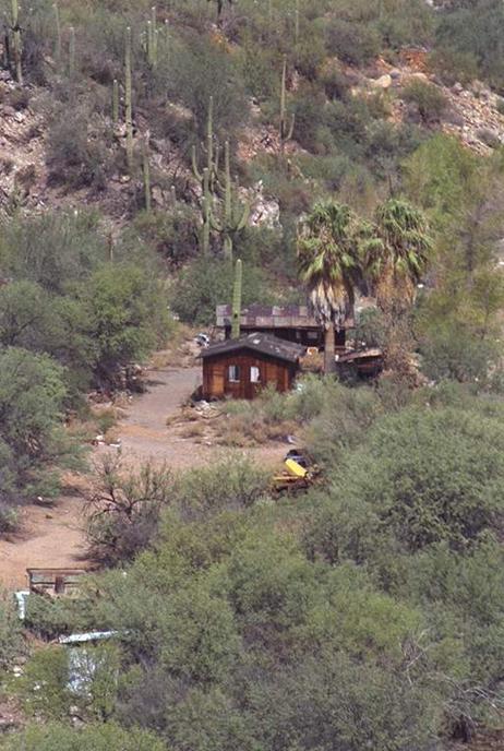
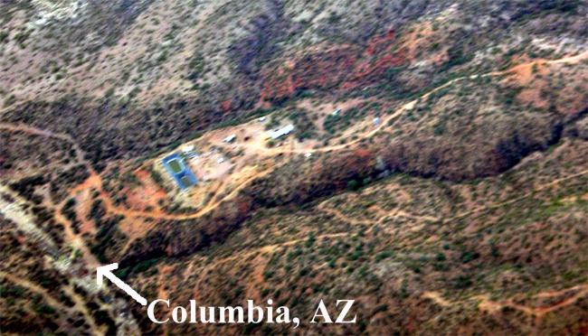
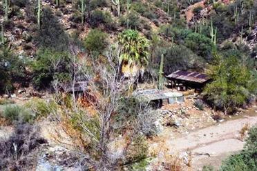
start to see the remains of Columbia (Figure 14). This is on private land so
do not trespass (Figure 2). Not much is left of Columbia due to the destruction
of the buildings and equipment by the government some years ago. There are
still two or three palm trees that identify the location of the community
(Figure 23).
Figure 7
Photograph courtesy: Neal Du Shane, Pilot:
Gary Grant
Aerial View of Columbia, Arizona - to the center of
the photograph is the ore processing operation, two settling ponds and home of
George and Marguerite Walters.
Figure 8
Spanish Arrastre Photograph courtesy: Neal Du Shane
\Ar*ras"tre\, n. [Sp.] A crude apparatus for
pulverizing ores, especially those containing free gold. This circular device with
a circular trough was used to crush gold bearing rock. In this picture the
center pivot metal axle would have had a horizontal bar attached to it. This
bar would have either been made of wood or metal. At one end of the bar was a
“Drag Rock” of considerable weight which
would have been attached by rope, chain or cable. At the other end of the bar
was a “beast of burden” that walked the perimeter of the Arrastre’s circle and
the ore bearing rock would be crushed. Once pulverized the fine rock
concentrate would be processed to extract the gold.
Locating an Arrastre is evidence of early miners working
small mining operations, long before mechanical miners arrived. Arizona became a
Territory on March 12, 1862 and after that date, this area was no longer
legally Mexico and became illegal for Mexican Miners to own mining property or
mines. Many mines in that era where acquired by European prospectors simply
coming in to existing operations and taking the operations over from the
Mexican miners. Arrastre’s predate stamp mills and other more modern methods of
processing rock containing gold, silver, etc.
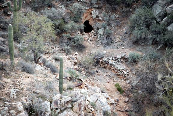
Figure 9
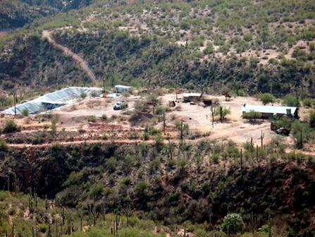
This is not Columbia: this is the ore processing operation for mines in
the area.
Columbia is to the left at Humbug Creek’s edge.
Photograph courtesy:
Neal Du Shane
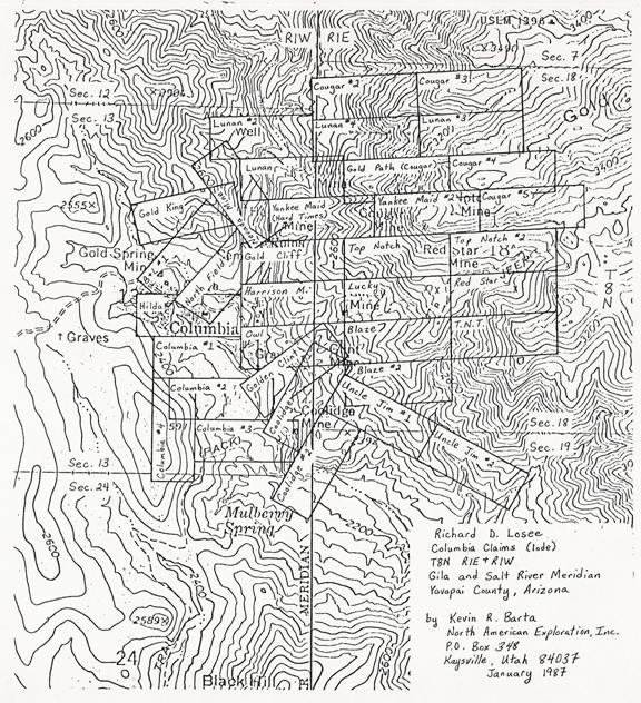
MAP
OF COLUMBIA AND AREA MINES – 2007
Figure 10
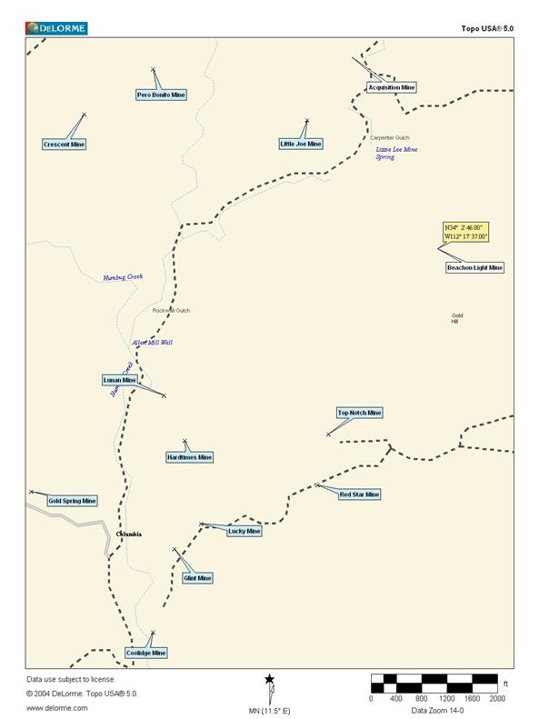
Figure 11
Photograph source: Unknown
Figure 12
By: Dave Burns
Occident Camp and the mill in the picture (Figure 11) was
associated with the Acquisition Mine in Carpenter Gulch. Over the ridge to the
east of Humbug is Rockwall Gulch. The next canyon east
is Carpenter Gulch. It is 2 miles from Columbia to Occident Camp, now referred to as
Acquisition Mine (Figure 11 & 26).
The old mill is gone, of course, and in its place a cyanide plant was built sometime in the 1970's. It was
never used. There is evidence of an extensive drilling program, and
apparently no ore was ever found. Getting there is difficult. (Figure 26)
When Dave Burns went, he walked from Humbug across Rockwall Gulch to Carpenter Gulch, then down Carpenter Gulch
to Swilling Gulch, down Swilling to Humbug
Creek, then up to Humbug. It was
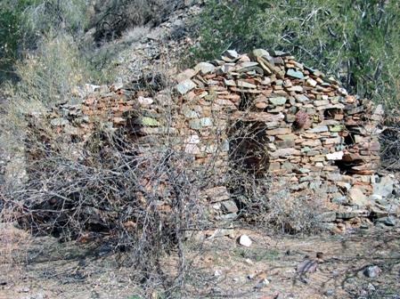
a long day, but lots to see, including the Beacon Light Mine (with several ruins) and Little Joe Mine.
The average grade in the two miles from Columbia to the old Occident
Camp is 8% with a few 25% and one 35% grade. From the north end of Columbia it is currently a foot trail to/from Occident
Camp/Acquisition.
Figure 13
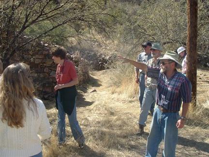
Dave Burns (Pointing)
Humbug’s yearly March Open House, giving tour at
Humbug, Arizona
Photograph courtesy: Reba Wells Grandrud
It is an extremely difficult trail to go through Columbia, up Gold Hill, east to Tip Top, then northwest to Carpenter
Gulch. To get there by 4X4 high clearance vehicle, or ATV, dirt bike, you
would have to come from the east side of the Bradshaw’s starting at Gillett, through Tip Top. (Figure 12)
Dave is very interested in what you read about the stamp
mill north of Humbug. There is evidence of a
stamp mill in Rockwall Gulch, northeast of Humbug,
but I have never heard anything about it. Please relay that information
and let’s see if they line up.
Southeast of Humbug, there were two mills where Swilling Gulch comes into Humbug Creek. The first was Charley
Champie's. His old boiler is
still there. The second was Allen Mill and a large stone foundation is still there.
Also, there are a couple of stone houses still there.
Figure 14
The Post Office – Columbia, AZ.
Photograph by: Neal Du Shane
At Cow Creek Road and Columbia Trail there was a ranch, called the XP Ranch, and a toll house. This area
may also be known as “Indian Springs”.
The road to Crown King (Crown King Trail) was, many years ago, a toll road. There was a small
hotel there, and in the 1930's, a resort. If you look on the west side of
the road, there is an old swimming pool with three structures still standing.
There is evidence of foundations sprinkled about this general area that
indicate this was a fairly large community and there is dam slightly past the
structures going northwest on Cow Creek Road.
JACK SWILLING KNOWN TO HAVE VISITED COLUMBIA
In mid-April of 1878, Jack Swilling, George Munroe and Andrew Kirby rested at Columbia. Jack and company had left
Gillett on a sojourn
promoted by Trinidad Swilling and assisted by Munroe and Kirby, to sober
Jack from his ever increasing binges of alcohol and morphine to the point of
insanity. It was Trinidad’s intent that this three day trip would turn Jack’s
life around. Drug abuse treatment programs as we know them today were
non-existent in 1878.
The Arizona Miner of April 8, 1871, reported that Snively and
four other men, one of them Andrew Starar, were attacked by about 180
Indians at White Picacho Mountain.
The account said Snively fell wounded at the first fire “and
was left to the mercy of the savages by his comrades, who became
panic-stricken, and ran away."
Snively was a long time friend of Jack and Trinidad
Swilling. Jack’s benevolence was known to search out, exhume and re-inter the
remains of others, to a more populated and respectable location to be near
friends, family land civilization.
On this trip in mid-April of 1878 Jack Swilling, George Munroe and Andrew
Kirby were accused and eventually arrested for a stagecoach robbery two miles
west of Wickenburg. For which they were innocent
of all charges but never-the-less they endured a trial in Prescott on the charges.
On this trip to exhume Col. Snively, the first afternoon was spent traveling from
Black Canyon through Gillett, west to Tip Top then to Humbug Creek. It is believed they rested
for approximately four hours at Columbia. They then completed the
first day’s trip by reaching Castle Hot Spring that evening and spending the night.
One can only surmise they rested their weary sour muscles in
the soothing, sobering waters of the resort. The next day they reached the
White Picacho Mountain and exhumed Col. Snively’s remains and put them in a
gunnysack for transportation back to Black Canyon City.
Upon returning to Black Canyon City, Jack was seen with the
gunnysack with Col. Snively’s remains walking about Black
Canyon City and Gillett, for what reason history does
not provide. Eventually Jack placed the remains of Col. Snively next to his deceased eight-year-old daughter
Matilda Swilling at their residence, which still stands in
2007. This structure was and still is referred to as the Swilling Stone House. The burial of five people in
the Swilling Stone House back yard is referred to as the Swilling Cemetery
(Figure 15).
As it turned out Jack Swilling was in ill health and this trip was the last
one he made as a free man. He was arrested and jailed shortly after returning
to Black Canyon City and after the trial in Prescott, Swilling, Munroe and Kirby were acquitted. But
a new trial was required as the courts discovered they had tried the accused in
Yavapai County and the actual robbery took place in Maricopa
County. They carted the three
accused Stagecoach Robbers to Yuma County Jail (not the Territorial Prison) and Jack died
there at 6:30 PM, August 12, 1878 in the Yuma County Jail. George Munroe and Andrew Kirby were never tried again and were released from
Yuma County Jail in October 1878 after law enforcement caught the three
individuals that actually committed the stagecoach robbery.
Figure 15
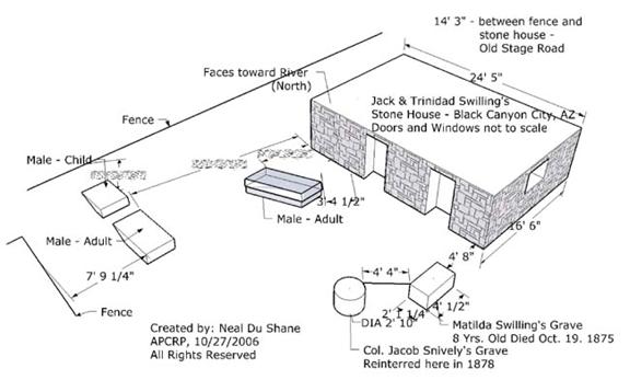
Grave locations - Swilling Cemetery at Swilling Stone House in Black
Canyon City
Drawing created and
documentation of graves by: Neal Du Shane APCRP
By: Neal Du Shane, APCRP
Figure 16
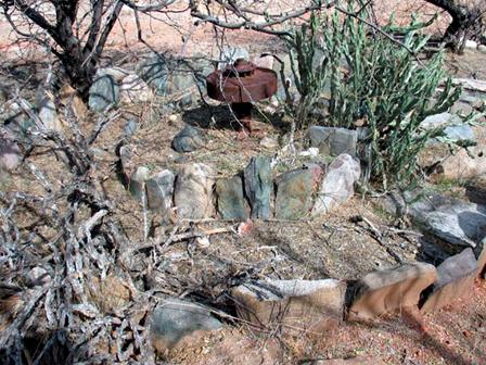
2007 – Columbia Cemetery – Grave of a baby girl.
Photograph by: Neal
Du Shane
Thanks to the property owners Mr. and Mrs. Losee and very gracious caretakers Betty and Larry
Gill we were able to locate the Columbia Cemetery with approximately 12 to 15 burials.
One of which is believed to be a daughter of Pioneer
Prospector. At first research it was
believed this was the Champie baby. History records the baby was crying at the
time, and no one could figure out why. They removed his diaper and discovered a
scorpion had gained access inside the diaper and it had stung the baby several
times. This is not the Champie baby
grave. I outlined with rocks the burial plot. (Figure 16)
The ashes of George and Marguerite Walters are sprinkled on
Gold Hill at the Cougar Mine. We have also documented the grave of a O.E.
Penney 1874- 1955. (Figure 20)
Curly McKibby’s ashes were interred in his favorite “Lucky”
gold pan at the foot of his favorite Saguaro on his claims.
Please don’t trespass on private mine property or destroy
these museums of our heritage as this is a felony and most property owners
prosecute. Disregard my previous statement regarding Larry & Betty being
gracious, if you decide to trespass (Figure 2).
At the present writing, there are seven burial locations
documented and identified, a complete roster of the interred and additional
information on the Cemeteries and Graves in and about Columbia and Old Columbia refer to (Figure 38).
Figure 17
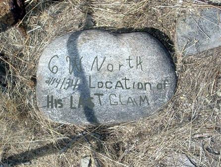
Headstone of C.W. North who died February 14, 1934,
buried at his grave near Columbia, Arizona. “Location of His Last Claim”. Photograph
and enhancement by: Neal Du Shane
This marker/headstone’s hand chiseled lettering is so faint
it required special techniques to ascertain the actual lettering by Larry Gill and Neal Du Shane. To save others the task of
reading his headstone we took the liberty to enhance the lettering to make it
legible.
Whenever possible, attempts to high light the actual chisel
marks were followed keeping it as authentic as possible recreating the
original.
Figure 18
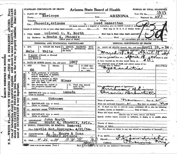
Death Certificate implies Col. C.W. North was buried at
Castle Hot Springs which is not accurate. His grave is at the
ghost town of Columbia, Arizona, there is an internment
of a male adult in the grave with the headstone (Figure 17) placed at the grave
site.
Figure 19
Grave. Photograph by: Neal Du Shane
Follow the BLM access road signs across the creek to the east.
As you start to climb up out of the creek, you will pass over a cattle guard.
On the right approximately 200 feet you will see the burial plot of “C.W. North 2/14/34 Location of His Final Claim”. From his death certificate
he was listed as a Colonel C.W. North and his brother was John North of Phoenix.
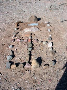
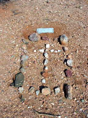
Another individual burial site is that of an adult male
(Figure 19). It is located on the left (North) of the main driveway about
halfway between where the road “Y”’s and the gate to the present mine
buildings. There is no headstone or marker, but the grave is clearly marked
with rocks outlining it. In 2007 I made a rock cross in the center of the grave
enclosure to help identify its location. At this time there is no record of
this person or how/when he died. We can only speculate he may have been a
miner.
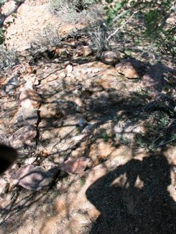
Figure 20
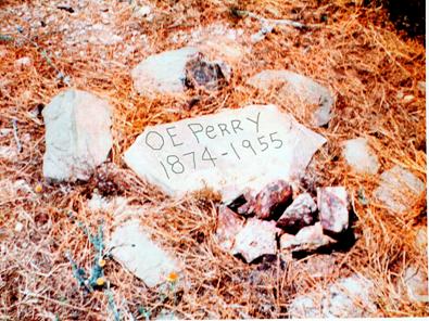
Photo enhancement by: Neal Du Shane
Photograph courtesy Mr. & Mrs. Losee
Photograph at right is the grave of O.E. (Orville) Perry, born Sept. 9, 1874, died
Feb. 17, 1955. Location of this grave is on Gold Hill in the area of Columbia, Arizona.
Margarite Walters maiden name was Perry, speculation is this
grave may be the grave of her father. There has been no documentation to this
effect found.
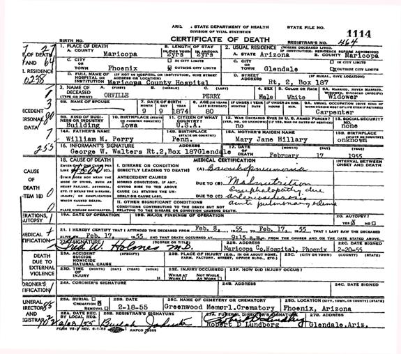
Figure 21
At the north “T” intersection on Columbia Trail, topographical maps show graves on the
northeast corner. We dowsed this area and did find possibly three or four
gravesites. Nothing is known regarding who the graves are or the circumstance’s
that caused their burial here.
Larry and Betty are presently keeping the main house in good
repair at the ore-processing site living there when ever possible. Larry has a
mine claim up Humbug Creek about a half-mile that he works as time
permits.
What has been written about Columbia in the past, places the town incorrectly. The
town of Columbia is actually closer to the creek on a flat spot on the west
side of Humbug Creek below the current ore processing buildings and
holding ponds. There are still two palm trees, rock embankment wall, some
remnants of the homes and a cement foundation of the ball mill.
All the buildings and equipment were removed from Columbia
by BLM in 2005. Little
remains of the actual town except for trees and a few foundations.
Figure 22
Downtown Columbia, Arizona c. 2006. L-R Cathy Johnson, Neal Du Shane,
Teri Thorpe & Larry Gill. Photograph courtesy: Reba Wells Grandrud.
George Walters started most, if not all of the mines as the
former owner and operated here for years before selling to
the Losee’s. Mr. and Mrs. Losee started the most current exploration at
Columbia in the 1960’s and 1970’s. They brought in Joe Stocks as technical advisor and did a substantial
drilling program on Gold Hill and the ridge north of George Walter's house
(Figure 9).
The exploration program was not productive. The history of
this area of Arizona is for gold to occur in small pockets and difficult to
find by drilling. At this time, a
promoter named B.J. Washburn appeared and convinced Mr. and Mrs. Losee to
invest in a cyanide processing plant.
This led to disagreements with Joe Stocks, as cyanide is not generally
workable with gold bound in quartz, and since no deposits had been found, there
was no indication that such a plant would ever be useful. But Washburn convinced Mr. and Mrs. Losee to
invest. Gold bearing ore was never
discovered on these expeditions or processed.
When Dave Burns came into the area in 1981, the Columbia operation had just closed. There has been no
activity in Columbia since 1980.
Dave is unaware of any production from these operations,
although I have heard that George Walters may have had some successes with the Cougar
Mine and Top Notch Mine, both mines are up on Gold Hill (Figure 10).
The five-stamp mill that has been referred to at Columbia may have been at the Allen Mill right at the junction of Humbug Creek and Swilling Gulch. The Allen Mill came after
the Champie Mill that is just down Humbug Creek.
There are considerable stone foundations and a large well at
Allen Mill. Champie Mill was smaller, with a few stone walls and the
old boiler.
George Walter's house is the main building on the ore
processing and holding ponds area that Larry and Betty Gill currently reside in
2007 (Figure 9).
Figure 23
 Columbia 2000 – Looking
down from Gold Hill
Columbia 2000 – Looking
down from Gold Hill
Photo courtesy: Kevin Hart.
It is Dave’s understanding that the small stone building
across and just up Humbug Creek from George Walter's house was the post
office, and that the saloon (probably a frame structure) stood next to it. The stone house across and down the creek was
a residence (Figure 14).
It has not been documented that a stagecoach ever ran
through or to Columbia, as Columbia was a dead end
road for wagons coming from the west off Cow Creek Road, past Humbug and Old Columbia.
The current Columbia Trail was a pack trail until 1970, when the
trail was improved into a road as part of the real estate development
subdividing the area into 40 acre lots.
The pack trail down Swilling Gulch from Tip Top to Columbia was never wide enough for wagons. Today
Swilling Gulch is still a trail.
In 2005, BLM demolished the structures and hauled off the
equipment at Columbia, that were built in the 1960
- 1970's.
It is my understanding that the current road over the top of
Gold Hill did not exist in Swilling's day (1870’s). The
pack trail down Swilling Gulch from Tip Top was the main thoroughfare in the Columbia area (Figure 10).
The saloons along the route, at Tip Top and Columbia, may have influenced Swilling's decision to go
this route and may have also necessitated the four-hour rest at Columbia. In those days it was not unusual for
travelers to drink in the saddle which equates to Riding Under the Influence (RUI).
If this were the case, I’m sure Trinidad did not factor this into her theory to
send Jack on this trip to sober him.
The majority of the lode producing mines were up on Gold
Hill across Humbug Creek to the east of Columbia. Mines and Claims by the name of:
All but the Gold Spring Mine, were on Gold Hill. Although there is several
placer mines along the Humbug Creek leading to Columbia (Figure 10).
According to Arizona Department of Mines and Mineral
Resources database of mines there is a BEACON
LIGHT MS 1396, UNPAT. file 914A, Columbia topo map, N34 02 46 W112 17
37 Township 8N, Range 1E, Section 7, quarter SE. (Ref. Kevin Hart, Arizona Department of Mines and Mineral Recourses)
In reviewing Topographical maps there used to be a trail
from Columbia to Castle Hot Spring some 6.16 miles away SW. Shortly after leaving
Columbia, a short distance south on Humbug Creek the trail took off toward Castle Hot Spring
(Figure 10).
George Walters owned the claims at Columbia prior to Mr. and Mrs. Losee. George Suber was the caretaker prior to Larry and Betty
Gill, and Mr. and Mrs. Losee purchasing the claims. It is believed George Suber lives in or about Yarnell, Arizona, the last we have
been able to determine. At this printing we have not been able to reach Mr.
George Suber.
29 April 1985
This property consists of 23 mining claims located in
Township 8 North, between Range 1 West and Range 1 East, bisected by the Gila
Bend and Salt River Median, in the Bradshaw Mountains north of Morristown, Arizona
Access to the property is from the intersection of Castle
Hot Springs Road and Arizona Highway 93 (Phoenix to
Wickenburg). Where Castle Hot Springs Road crosses State Highway 74 it becomes
an unimproved graded dirt road. The road is easily traversed by any vehicle for
a distance of 27.1 miles when it becomes much less easily traveled, and should
be traveled in a four wheel drive (high clearance) vehicle for the remaining
four miles. At least two hours and 15 minutes should be allotted to make the
journey to the claims.
Columbia, Arizona was an active mining
town at the turn of the century (1900). The claims were acquired by George
Walters in the late nineteen twenties and he resided
on the property and mined it for various minerals until the late nineteen
seventies. Many of the claims have been
extensively worked, and there is evidence of the presence of long time
residents in the area, including several gravesites.
A review of affidavits filed with the Phoenix Office of the
Bureau of Land Management reveals that all assessment work required to maintain
title to the claims has been done effective to September 1, 1985. The file also
reveals that ten individuals have examined the file maintained on these claims
since January 1983. These individuals live in various parts of the United
States
Claim markers were difficult to locate. For that reason, it
could not be determined if one mine was on the Owl claim or on the Harrison M. claim. It is assumed that one
mine, which has collapsed to within six feet of the adit was on the Owl claim. In one of the mines on the Harrison M. claim, a visible vain of
gold bearing quartzite about a foot deep was plainly visible which thickened as
it ran back into the mine where mining was suspected. No attempt was made to
estimate the richness of this ore due to lack of tools and assay equipment.
There is several building on the property. The Walters
residence is well built, 1,158 sq. foot structure dating from the fifties. It
has foot thick concrete exterior walls, a slab floor, and a corrugated sheet
metal roof. There is an attractive stone fireplace and chimney, tow bedrooms,
bath, kitchen, an attached garage and workshop. The home has ample cabinets and
closets. It has a wash house with an outside shower built adjacent to the
house.
The house is furnished with beds, table, chairs, sofa,
overstuffed chairs, electric kitchen range and a working refrigerator. There is
evidence of occupancy as late as March 1984, probable by persons doing
assessment work.
Near the main house is a tool shed for the storage of hand
tools, truck repair, etc. It is wired to provide for the use of power tools,
and there was evidence of some assay work having been done there. Nearby is an
old International truck which has been scavenged for parts, and is now useless
to a mining operation. There is one other structure near the tool shed which
may have served as a garage or storage building.
A building on the Coolidge claim adjacent to the Coolidge Mine appeared to be much younger than the main
house. It could not be reached without a four wheel vehicle, but, viewed
through binoculars from the Luck mine, appeared to be a two bedroom
house or bunkhouse.
There is a bunkhouse with kitchen and two bedrooms on the
old Columbia townsite surrounded by an assay building, tool
shed and a cook house. Nearby is a windmill which provided water to the
community. The Humbug Creek flows adjacent to the townsite and appears to
provide an ample water supply. There are also corrals and watering basins for
pack animals and/or cows.
There is a crusher on the property which may be usable.
There is also a ruin of a rock walled building which probably served some very
early mining party. This ruin appears to be more than a hundred years old.
The roads on the claims are in good repair for four wheel
vehicles, and can readily be used immediately without further work being
necessary. Since road building is a major cost in a mining operation, the
significance of good roads on the property should not be underestimated.
Since the geologist’s report recommends keeping the property
for further development, and since the price of gold is predicted by
substantial economists to rise due to a widely expected monetary inflation
within the next five years, this property offers an opportunity to capitalize
on these economic conditions.
PERSONS WHO HAVE REVIEWED THE BLM FILES ON THESE CLAIMS
E. P. Larson 3 Jan. 1984
15601 No. 19th Ave.
Phoenix, AZ 85023
Carolyn McDowell 6 Jan. 1984
8935 West Peoria 17 Jan.
1984
Peoria, AZ 85345
Carl Anderson 6 Mar. 1984
P. O. Box 270270
Tampa, FL 33688
David R. Nielsen 26 Mar. 1984
15 South 1250 East
Bountiful, UT 84010
Frederick P. Schwartz 26 Apr. 1984
3142 Scenic View Dr. #8
Elko, NV 89801
James A Hutchinson 27 Aug. 1984
P. O. Box 1949
Glendale, AZ 85311
Joe Stocks 14 Dec. 1984
1911 Murphy Lane
Moab, UT 84532
Larry D. Robinson 18 Dec. 1984
12419 No. 29th Place
Phoenix, AZ
Ray DeMoss 3 Jan. 1985
2739 No. Pierce
Phoenix, AZ
James E. Craddock 26 Apr. 1985
759 North 550 East
Orem, UT 84057
The last assessment affidavit was signed by E. P. Larson, address cited above, in
behalf of the present owners, Richard D. and Jo Ann Losee.
By
Forest Brayshaw
January 1974
Humbug Mining District
Sections 13 & 18, Township 8
North, Ranges 1 East to 1 West. Yavapai County, Arizona.
Area:
1 placer claim, 22 lode
claims, 496 acres.
Ore Type:
Approximately half of
the claims extend into Humbug Creek, there fore suggesting placer
mining. Some of these claims also have hard rock ore. The remaining claims are lode
or hard rock. Placer sampling indicates gold from 0.5 to 2.0 oz. per ton, or
yard. Silver runs from 0.5 to 2.0 oz. per yard and a trace of platinum. There
is reason to believe that in some areas of the old stream bed gold could go as
high at 10 to 15 oz. per yard with higher values of silver and platinum.
Sampling of all ore piles, shafts, and open cuts on the lode claims indicates
values of gold from 0.5 to 12 oz. per ton. Some samples have gone as high as 20
oz. per ton. A table of samples taken from the claims may be found on page 7.
Recovery
Method:
A total of 2,000 lbs
from all 23 claims was hand crushed to 100 mesh. 12 samples (2 lbs each) were
run each day for 83 days. From each 2 lb. sample 60 grams were taken and panned.
The gold was recovered with mercury. 2 milligrams of gold = 1 oz per ton.
Concentrates:
The black sand from all
the concentrates was saved and run through a low temperature plasma. On most
samples it has increased the recovery from gold and platinum. It is not yet
know why it doesn’t work on all samples. In most cases it has increased the
values 1.5 to 2 times.
Placer
Recovery:
In trying to determine
the best method to use for placer recovery, a Pan-O-Matic Model 850 was used on 4,000 lbs. of placer ore. 2,000
lbs. were run with water and then the machine was converted to run dry and
another 2,000 lbs were run. The wet method is approximately 25% more efficient
in recovery and at least 50% faster than the dry method.
Silver:
Some silver is present
in both the hard rock and placer ore. The average ratio of gold to silver seems
to be about 100:1 for the placer ore. The average for the hard rock is much
higher, with silver sometimes going higher than gold.
Platinum:
This metal has been
evident to both hard rock and placer but no quantitative analysis, has been
made doe to the small amounts of ore handled.
Areas to be
Mined:
Based on the recovery of
gold from samples taken, the best placer mining seems to e on the North Field, Owl and Star Placer claims. These three claims are all
within 600 feet of the bunk house. There are other good areas, but these are
close and are quite easy to get into. When the time comes for hard rock mining
the Harrison, Yankee Maid 1 & 2, Gold Path and Lunan 1, 2, 3, & 4 are the best claims.
Method of
Mining:
For placer mining a backhoe
with a front loader can be used to remove the overburden and stockpile the pay
dirt. The backhoe can also be used for quite a large part of the hard rock
mining.
Water:
One or more wells must
be dug in order to run the necessary recovery equipment. To have a 8” well
drilled to a depth of 200 feet will cost approximately $2,000.00. The last rain
we had at the mine produced some good evidence of where water could be found at
depths of 30-40 feet. These wills could be dug with a backhoe in a very short
period of time and will produce enough water for the entire operation.
Conclusions:
There have been quite a
few nuggets taken from Humbug Creek over the past 65 years. I have found a few
myself so I know they are there. Placer gold, or free gold, is washed out from
a rich deposit and carried down stream for a distance, there to be covered over
with rock and sand. Whenever I find a nugget my first thought is: “I wonder
where that came from? In taking placer samples from just north of our claims to
12 mile south of our claims I have noticed one very evident fact: the higher
values of placer ore are within our claims. This means that the free gold being
washed into Humbug Creek comes from Gold. Mt. and our claims cover the entire
west side of that mountain. It’s the west side that drains into the creek. Some
of the hard rock samples I have taken from drainage areas on Gold Mt. have gone
as high, as 400 oz. per ton. I have some samples that show large amounts of
free gold. I believe the question is no longer: “Is there gold here?”, but
rather what is the best way to find it and recover it?
Figure 24
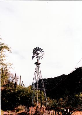
Windmill at Columbia, Arizona Photograph courtesy: Mr. & Mrs. Losee
Claim No. Samples Avg. per ton
Uncle Jim No. 1 10 0.5 oz.
Uncle Jim No. 2 10 0.5
Coolidge 35 1.0
Golden Glint 10 1.0
Star Placer 25 1.0
Owl 10 2.0
Harrison 75 3.0
Lucky 50 2.0
Blaze 50 2.0
T.N.T. 50 2.0
Red Star 50 2.0
Top Notch No. 1 50 2.0
Top Notch No. 2 50 2.0
Gold Cliff 50 2.0
North Field 75 3.0
Yankee Maid No. 1 75 3.0
Yankee Maid No. 2 75 3.0
Gold King 50 3.0
Gold Path 100 4.0
Lunan No. 1 25 2.0
Lunan No. 2 25 2.0
Lunan No. 3 25 2.0
Lunan No. 4 25 2.0
Figure 25
Columbia Claims (Lode)
1987. Photograph courtesy: Mr. & Mrs. Losee
DIRECTIONS FOR FINDING COLUMBIA, ARIZONA
THE FOLLOWING DIRECTIONS WERE WRITTEN IN 1974.
SIGNS, LANDMARKS AND ROADS CHANGE OVER TIME.
WE ASSUME NO RESPONSIBILITY FOR THE CURRENT
ACCURACY OF THESE DIRECTIONS.
Proceed to Morristown, Arizona from Phoenix on Arizona
Highway 93 (US 60/89).
Turn north (right) on Castle Hot Spring Road. This road does
not appear on the Arizona Highway map. Proceed north on Castle Hot Springs Road which becomes an unimproved, graded road
within less than a mile where it transects Arizona Highway 74. After traversing
20.5 miles of Castle Hot Springs Road, a fork is encountered marked with a sign
“Castle H. S.”. Take the right fork and proceed on the wide graded road another
.95 miles where an unmarked turn is encounter which must be ignored.
The nest opportunity to turn off the road occurs 2.5 miles
at the fork for the Champie School. Take the right fork at this
point and proceed .4 miles to the next fork. Take the right fork and proceed an
additional .9 miles to where the road appears to end at a “T”. This
intersection in unmarked, as are most of the intersections. Turn left at this
point and follow the road (locally termed the “Morristown Road”) and travel 1.9 miles to a gate
which is the entry to the VX Ranch. Pass through the gate, close
it, and take a right fork which does not appear to be a road. It looks more
like a place where the stock go to water at the creek which you must cross, and
where the road becomes considerably less hospitable.
Follow this “road” for 2.1 miles where a fork occurs which
is the access road to the Humbug mine on the left and the Columbia Claims on the right. Again, the road seems to
disappear as if crossing a creek bed. If a windmill does not appear within
three tenths of a mile, you have taken the wrong road.
Proceed on this trail another 1.6 miles to the main gate of
the Columbia claims. After passing through the gate and
closing it, drive carefully to the main house, about a tenth of a mile.
THESE DIRECTIONS WERE WRITTEN IN 1974.
SIGNS, LANDMARKS AND ROADS CHANGE OVER TIME.
WE ASSUME NO RESPONSIBILITY FOR THE CURRENT
ACCURACY OF THESE DIRECTIONS.
PRIMARY REPORT
HUMBUG CREEK, YAVAPAI
COUNTY, ARIZONA
Prepared for
MR. RICHARD D. LOSEE
Prepared by
BERGE EXPLORATION
INC.
September 1977
PRIMARY REPORT
ECONOMIC GEOLOGY OF
THE COLUMBIA CLAIMS
HUMBUG CREEK, YAVAPAI
COUNTY, ARIZONA
Mr. Richard D. Losee of Bullock and Losee Jewelers, (currently
Losee Jewelers) Provo, Utah, has acquired the George W. Walters Claim Group at
Columbia, Arizona in the Humbug Mining District. There are in the group, a
total of 22 load mining claims and one placer mining claim. All claims are
unpatented. The claims are listed below:
Load
(sic) Claims: Lunan
Lunan
No. 2
Lunan
No. 3
Lunan
No. 4
Gold
Path (Cougar)
Gold
King
Yankee
Maid (Hard Times)
Yankee
Maid No. 2
North
Field
Gold
Cliff
Top
Notch
Top
Notch No. 2
Harrison
M.
Lucky
Red
Star
Hilda
Owl
Blaze
T.
N. T.
Golden
Glint
Coolidge
Uncle
Jim No. 1
Uncle
Jim No. 2
Placer
Claim: Star Placer
The claims were acquired from Mr. George Walters who presently resides on the property with his
wife and acts as a care taker for the Losee’s.
The claims are located along Humbug Creek, around the old town of
Columbia. Most of the mineral showing
and old mines are located on the east tide of Humbug Creek, just west and
southwest of Gold Hill.
Mines were observed on the Lunan, Gold Path, Yankee Maid, Yankee Maid No. 2, Red Star, Lucky, Harrison M. and Coolidge Claims; and workings were
observed on most other claims. Much of the work is obviously near the surface
as mine dumps are either small or nearly non-existent. Veins which were
observed were thin, but appeared to be quite continuous. The thickest vain
observed was at the Lucky Mine where it appeared to be about 3 feet thick.
Old reports indicate that the mining commenced about 1880
and was carried on intermittently to about 1908. The ore was ground in
arrastres and panned or sluced to recover the gold. Later C.E. Champie operated a 4 stamp mill at Columbia from about 1900 to 1905. Little activity in
the area was present until about 1932 when ore was again mined for a couple of
years. Test shipments from surface veins and tunnels in the 1930’s netted from
207 tons of ore, and average of 1.5 oz. gold and 3.5 oz. silver and 3.5 percent
lead. Ore has been mined from the canyon bottom up the mountain side for a
vertical distance of over 1,000 feet. Veins here are on line with the Tip Top Mine located 3 ½ miles northeast of Columbia and there are old mine workings observed
throughout most of the intervening distance. The Tip Top Mine was mined to a
vertical depth of 1,200 feet. The evidence above indicates a vertical extent of
ore deposition of at least 1,000 feet. Ore shoots are not expected to extend
for a great distances, but the length may be over a couple of hundreds of feet.
The mineralized veins extend through the Pre-Cambrian rocks
and seem to cut all rocks present, except those rocks which are in recent
origin; ie, alluvium and volcanic rocks. Data reported and observed would seem
to indicate the origin of the ore bodies and their vein systems as post-Yavapai
Schist, and post-Bradshaw Granite, but Pre-Tertiary sediments and volcanics. In
all probability, the veins were formed at the close of the period of the
Bradshaw Orogeny in Pre-Cambrian Time, or they were formed in conjunction with
igneous activity in early Tertiary time.
Mr. George Walters indicated that his experience on the properties
indicated about ¼ of the vein system would be mineralized with ore grade
mineralization, while ¾ consists of ore grades too low to be economic or where
the veins are too thin to be mined economically. The better ore shoots are
located where two vain systems intersect or where the vein cuts more competent
rock types. The shattering of the rock prior to mineralization seems to be the
most important factor in the establishment of ore bodies.
The country rock of the area is composed of muscovite
schist’s and associated meta-sedimentary rocks. Interspersed, in concordant
masses with the mica schist are quartzite and intermediate rocks. These rocks
have been disrupted and intruded by quartz-feldspar pegmatite. In places, black
tourmaline was observed in the pegmatite veins and dispersed into adjacent
meta-sediments.
The veins of gold-bearing quartz cut all rock types, and
become more prominent in the quartzite and pegmatite. They seem to pinch in the
schist and swell in the more brittle rock type. Most ore minerals have been
destroyed by oxidation; however, galena, chalcopyrite, pyrite and native gold
were observed. The oxidized minerals recognized were malachite, azurite,
wulfenite, and a variety of iron oxides. Part of the native gold appears to be
primary and much appears to be of secondary origin.
The vein systems observed appears to strike in two principal
directions. One system appears to run nearly north-south with a tendency to
drift northwesterly. The second system has an east, northeast strike. The veins
are nearly vertical with the Lucky vein appearing to have about a 70 to 80
degree dip. The rake of ore bodies within individual veins was not observed.
The handing wall in the Harrison M. vein dipped northward at about 50 to 60 degrees
where observed in the mine. In the Harrison M. Mine, the vein appears to have been off-set by
later date faulting and the eastern extension was not found by previous mining.
The composite sample of vein material collected from the
Lunan, Harrison M and Red Star Mine dumps was ground in a crusher of Columbia and assayed for gold, silver, lead, molybdenum
and tungsten. The assay report is attached to this report. It should be
emphasized that this sample is indicative of ore rejected while mining as
conducted on the properties and should not be considered to represent true ore.
The first figure was from a placer grab sample and probably is of little value
either as to grade or potential. A proper placer sample would require the
processing of about a yard or more of gravel and the assay of the concentrate
were obtained.
The load sample indicated 0.064 oz Au/ton, 0.48 oz. Ag/ton,
0.78% Pb, 0.05% Mo, and 0.05% WO3. This composite sample should only be
considered to represent waste, rejected in initial mining.
RECOMMENDATION
It is recommended that the claims be retained, and later
patented if possible to gain both mineral rights and also surface rights. Assessment
work should be diligently accomplished by the owners, with sufficient surface
disturbance; ie, road building and excavation to provide proof of labor. It is
further recommended that the possibility of a joint venture with a mining
company be considered. Selection of a joint venture partner should be done with
care as many properties are destroyed if proper mining and geology are not
provided. The claims should not be allowed to lapse in any case.
September 16, 1977 (Signature)
DEFORREST
SMOUSE
Division
Geologist
The following
reproduced pages were notes by George Walters, made in this
Diary Note Book.
|
The following
DIARY was recorded by George Walters in 1934 on the dates indicated. It is
believed these notations were made shortly after he purchased these claims.
When he found a spot the previous owners had missed, he mined and shipped it,
similar to a clean-up operation. It is comprised as a log of samples and
shipments.
|
|
|
|
|
|
|
|
|
|
|
|
DIARY
|
|
and Daily Reminder
|
|
A Page a Day for 1935
|
|
Yankee Maid Group (North Mines)
|
|
Columbia, Post Office
|
|
South of Humbug on Humbug Creek
|
|
|
|
|
|
|
|
|
|
|
|
601
Harison (sic) Ledge - 64 ft. Tunnel 1934
|
Date on
pages Jan 2-3, 1935
|
|
Date sample taken
|
Sample taken "in" from
Adit entrance
|
Width of Vain
|
Oz. of gold per ton
|
|
|
|
3/16
|
16 ft
|
In
|
8 inch
|
W
|
Assay
|
1.86
|
|
|
|
4/12
|
24 ft
|
In
|
6 inch
|
W
|
Assay
|
1.58
|
|
|
|
5/3
|
38 ft
|
In
|
8 inch
|
W
|
Assay
|
1.12
|
|
|
|
5/30
|
53 ft
|
In
|
8 inch
|
W
|
Assay
|
1.44
|
|
|
|
6/8
|
59 ft
|
In
|
12 inch
|
W
|
Assay
|
2.08
|
|
|
|
5/8
|
12 tons
to Mill
|
|
|
|
Assay
|
1.49
|
|
|
|
6/20
|
22 tons
to Mill
|
|
|
Assay
|
1.34
|
|
|
|
|
34
|
|
|
|
|
|
|
|
|
|
|
|
|
|
|
|
|
|
|
North
Harrison Ledge
1934
|
|
Date on
pages Jan 4-5, 1935
|
|
|
|
|
|
|
|
|
|
|
|
3/16
|
Cut
|
High
|
|
|
4 inch
|
W
|
Assay
|
2.04
|
|
4/12
|
Cut
|
High
|
15 ft
|
In
|
5 inch
|
W
|
Assay
|
1.83
|
|
5/2
|
Cut
|
High
|
99 ft
|
In
|
3 inch
|
W
|
Assay
|
0.83
|
|
5/30
|
Cut
|
High
|
46 ft
|
In
|
4 inch
|
W
|
Assay
|
2.26
|
|
6/18
|
Cut
|
High
|
52 ft
|
In
|
4 inch
|
W
|
Assay
|
0.64
|
|
5/30
|
Cut
|
Low
|
15 ft
|
In
|
4 inch
|
W
|
Assay
|
1.83
|
|
5/8
|
16 tons
to Mill
|
|
|
|
|
|
Assay
|
1.29
|
|
6/2
|
6 tons to
Mill
|
|
|
|
|
|
Assay
|
1.54
|
|
|
22
|
|
|
|
|
|
|
|
|
|
|
|
|
|
|
|
|
|
|
Lucky Tunnel 1934
|
|
|
Date on
pages Jan 6-7, 1935
|
|
|
|
|
|
|
|
|
|
|
|
4/16
|
12 ft
|
In
|
6 inch
|
W
|
Assay
|
2.09
|
|
|
|
4/16
|
29 ft
|
In
|
5 inch
|
W
|
Assay
|
1.14
|
|
|
|
4/16
|
38 ft
|
In
|
5 inch
|
W
|
Assay
|
2.34
|
|
|
|
4/16
|
49 ft
|
In
|
6 inch
|
W
|
Assay
|
2.18
|
|
|
|
4/16
|
86 ft
|
In
|
4 inch
|
W
|
Assay
|
1.10
|
|
|
|
4/16
|
South
Ledge Face
|
|
|
|
Assay
|
0.76
|
|
|
|
6/4
|
Old Ore
Pile 3 tons to Mill
|
|
|
|
Assay
|
3.19
|
|
|
|
|
|
|
|
|
|
|
|
|
|
119
Lucky Claim High 1934
|
|
Date on
pages Jan 8-9, 1935
|
|
|
|
|
|
|
|
|
|
|
|
4/8
|
Face
|
|
4 inch
|
W
|
Assay
|
2.25
|
|
|
|
5/12
|
15 ft
|
In
|
5 inch
|
W
|
Assay
|
1.89
|
|
|
|
6/1
|
29 ft
|
In
|
4 inch
|
W
|
Assay
|
2.49
|
|
|
|
6/18
|
26 ft
|
In
|
4 inch
|
W
|
Assay
|
2.22
|
|
|
|
|
|
Cut Low
|
|
|
|
|
|
|
5/12
|
Face
|
In
|
3 inch
|
W
|
Assay
|
2.11
|
|
|
|
6/11
|
12 ft
|
In
|
4 inch
|
W
|
Assay
|
0.1
|
|
|
|
6/19
|
34 ft
|
In
|
5 inch
|
W
|
Assay
|
2.26
|
|
|
|
5/16
|
6 tons to
Mill
|
|
|
|
Assay
|
1.84
|
|
|
|
6/10
|
5 tons to
Mill
|
|
|
|
Assay
|
1.63
|
|
|
|
|
|
|
|
|
|
|
|
|
|
164 Lucky
Claim 1934
|
|
|
Date on
pages Jan 10-11, 1935
|
|
|
|
|
|
|
|
|
|
|
|
2/19
|
Cut in
Face
|
|
12 inch
|
Ch
|
W
|
Assay
|
0.48
|
|
3/3
|
Cut
|
10 ft
|
in
|
14 inch
|
Ch
|
W
|
Assay
|
0.48
|
|
4/11
|
Cut
|
24 ft
|
in
|
14 inch
|
Ch
|
W
|
Assay
|
0.79
|
|
5/1
|
Cut
|
36 ft
|
in
|
18 inch
|
Ch
|
W
|
Assay
|
0.37
|
|
6/14
|
Cut
|
51 ft
|
in
|
16 inch
|
Ch
|
W
|
Assay
|
1.13
|
|
5/2
|
22 tons
to Mill
|
|
|
|
|
|
Assay
|
0.54
|
|
9/12
|
32 tons
to Mill
|
|
|
|
|
|
Assay
|
0.69
|
|
|
54
|
|
|
|
|
|
|
|
|
|
|
|
|
|
|
|
|
|
|
159 Lucky
Claim 1934
|
|
|
Date on
pages Jan 12-13, 1935
|
|
|
|
|
|
|
|
|
|
|
|
2/22
|
Cut
|
|
|
6 inch
|
W
|
Assay
|
0.86
|
|
|
4/12
|
Cut
|
|
|
8 inch
|
W
|
Assay
|
1.83
|
|
|
5/2
|
Cut
|
32 ft
|
in
|
8 inch
|
W
|
Assay
|
1.44
|
|
|
5/30
|
Cut
|
44 ft
|
in
|
8 inch
|
W
|
Assay
|
0.54
|
|
|
6/18
|
Cut
|
52 ft
|
in
|
6 inch
|
W
|
Assay
|
3.02
|
|
|
5/8
|
16 tons
to Mill
|
|
|
|
|
Assay
|
1.64
|
|
|
6/18
|
22 tons
to Mill
|
|
|
|
|
Assay
|
1.28
|
|
|
|
38
|
|
|
|
|
|
|
|
|
|
|
|
|
|
|
|
|
|
|
172
Top Notch Claim 1934
|
|
Date on
pages Jan 14-15, 1935
|
|
|
|
|
|
|
|
|
|
|
|
3/16
|
Face
|
|
6 inch
|
W
|
Assay
|
0.50
|
|
|
|
3/28
|
17 ft
|
in
|
6 inch
|
W
|
Assay
|
0.68
|
|
|
|
4/18
|
23 ft
|
in
|
7 inch
|
W
|
Assay
|
0.36
|
|
|
|
5/2
|
29 ft
|
in
|
7 inch
|
W
|
Assay
|
0.42
|
|
|
|
4/16
|
8 tons to
Mill
|
|
|
|
Assay
|
0.53
|
|
|
|
5/16
|
11 tons
to Mill
|
|
|
|
Assay
|
0.48
|
|
|
|
|
19
|
|
|
|
|
|
|
|
|
|
|
|
|
|
|
|
|
|
|
178 North
Star Claim 1934
|
|
Date on
pages Jan 16-17 1935
|
|
|
|
|
|
|
|
|
|
|
|
5/2
|
Face
|
|
|
6 inch
|
W
|
Assay
|
2.74
|
|
|
5/24
|
Cut
|
12 ft
|
in
|
6 inch
|
W
|
Assay
|
1.84
|
|
|
6/3
|
Cut
|
18 ft
|
in
|
6 inch
|
W
|
Assay
|
2.44
|
|
|
6/4
|
6 tons to
Mill
|
|
|
|
|
Assay
|
2.05
|
|
|
|
|
|
|
|
|
|
|
|
|
161 Top
Notch Claim 1934
|
|
Date on
pages Jan 18-19 1935
|
|
|
|
|
|
|
|
|
|
|
|
2/18
|
Cut
|
Face
|
|
5 inch
|
W
|
Assay
|
0.40
|
|
|
3/2
|
Cut
|
16 ft
|
in
|
8 inch
|
W
|
Assay
|
1.12
|
|
|
4/12
|
Cut
|
20 ft
|
in
|
6 inch
|
W
|
Assay
|
0.88
|
|
|
5/2
|
Cut
|
29 ft
|
in
|
7 inch
|
W
|
Assay
|
0.68
|
|
|
5/30
|
Cut
|
36 ft
|
in
|
8 inch
|
W
|
Assay
|
0.93
|
|
|
6/20
|
Cut
|
42 ft
|
in
|
5 inch
|
W
|
Assay
|
0.53
|
|
|
5/16
|
18 tons
to Mill
|
|
|
|
|
Assay
|
0.69
|
|
|
6/18
|
14 tons
to Mill
|
|
|
|
|
Assay
|
0.59
|
|
|
|
32
|
|
|
|
|
|
|
|
|
|
|
|
|
|
|
|
|
|
|
171 Gold
Path Claim
|
|
|
Date on
pages Jan 20-21, 1935
|
|
|
|
|
|
|
|
|
|
|
|
3/1
|
Face
|
|
|
8 inch
|
W
|
Assay
|
0.74
|
|
|
3/18
|
12 ft
|
in
|
|
5 inch
|
W
|
Assay
|
1.66
|
|
|
4/20
|
28 ft
|
in
|
|
7 inch
|
W
|
Assay
|
1.61
|
|
|
5/14
|
36 ft
|
in
|
|
7 inch
|
W
|
Assay
|
0.3
|
|
|
4/19
|
12 tons
to Mill
|
|
|
|
|
Assay
|
0.94
|
|
|
5/20
|
14 tons
to Mill
|
|
|
|
|
Assay
|
0.86
|
|
|
|
|
|
|
|
|
|
|
|
|
167 Golden
Glint Tunnel 1934
|
|
Date on
Pages Jan 22-23,1935
|
|
|
|
|
|
|
|
|
|
|
|
5/10
|
East of
Winch
|
|
|
2 inch
|
W
|
Assay
|
2.04
|
|
|
5/10
|
West of
Winch
|
|
|
3 inch
|
W
|
Assay
|
4.03
|
|
|
5/10
|
22 ft
|
in
|
|
4 inch
|
W
|
Assay
|
0.22
|
|
|
5/30
|
Top in
Stope
|
|
|
|
|
Assay
|
1.24
|
|
|
6/10
|
Top in
Stope
|
|
|
|
|
Assay
|
0.66
|
|
|
6/10
|
West from
Winch
|
2
ft down
|
|
|
|
Assay
|
3.78
|
|
|
6/10
|
13 ft
back from
|
Face
|
|
3 inch
|
W
|
Assay
|
1.42
|
|
|
6/12
|
12 ft in
Winch
|
|
|
|
|
Assay
|
3.16
|
|
|
6/18
|
5 tons to
Mill
|
|
|
|
|
Assay
|
2.48
|
|
|
|
5
|
|
|
|
|
|
|
|
|
|
|
|
|
|
|
|
|
|
|
167-148 Top
Notch Claim
|
|
Date on
Pages Jan 24-25, 1935
|
|
|
|
|
|
|
|
|
|
|
|
3/19
|
Cut
|
|
6 inch
|
W
|
Assay
|
1.52
|
|
|
|
4/16
|
Cut
|
|
8 inch
|
W
|
Assay
|
1.19
|
|
|
|
4/29
|
Cut
|
|
8 inch
|
W
|
Assay
|
0.88
|
|
|
|
5/18
|
Cut
|
|
8 inch
|
W
|
Assay
|
1.27
|
|
|
|
6/1
|
Cut
|
|
8 inch
|
W
|
Assay
|
0.98
|
|
|
|
6/15
|
Cut
|
|
10 inch
|
W
|
Assay
|
1.08
|
|
|
|
6/19
|
Cut
|
|
6 inch
|
W
|
Assay
|
6.48
|
|
|
|
5/14
|
24 tons
to Mill
|
|
|
|
Assay
|
1.04
|
|
|
|
6/17
|
29 tons
to Mill
|
|
|
|
Assay
|
0.99
|
|
|
|
|
53
|
|
|
|
|
|
|
|
|
|
|
|
|
|
|
|
|
|
|
161 - 147
Top Notch Claim 1934
|
|
Date on
Pages Jan 26-27, 1935
|
|
|
|
|
|
|
|
|
|
|
|
3/12
|
Old Cut
|
|
10 ft
|
in
|
6 inch
|
W
|
Assay
|
1.65
|
|
3/30
|
Old Cut
|
|
29 ft
|
in
|
8 inch
|
W
|
Assay
|
3.07
|
|
4/12
|
|
|
34 ft
|
in
|
8 inch
|
W
|
Assay
|
1.64
|
|
5/2
|
|
|
51 ft
|
in
|
5 inch
|
W
|
Assay
|
1.52
|
|
6/12
|
|
|
59 ft
|
in
|
5 inch
|
W
|
Assay
|
2.02
|
|
6/18
|
Stope
|
|
32 ft
|
in
|
|
|
|
0.84
|
|
5/3
|
17 tons
to Mill
|
|
|
|
|
|
Assay
|
1.83
|
|
6/18
|
19 tons
to Mill
|
|
|
|
|
|
Assay
|
1.29
|
|
|
36
|
|
|
|
|
|
|
|
|
|
|
|
|
|
|
|
|
|
|
169-110 Cugar
(sic) Tunnel 1934
|
|
Date on
Pages Jan 28-29, 1935
|
|
|
|
|
|
|
|
|
|
|
|
5/20
|
|
|
20 ft
|
in
|
4 inch
|
W
|
Assay
|
3.50
|
|
5/20
|
|
|
46 ft
|
in
|
5 inch
|
W
|
Assay
|
0.18
|
|
5/20
|
|
Winch
|
12 ft
|
down
|
4 inch
|
W
|
Assay
|
0.83
|
|
|
|
Winch
|
23 ft
|
down
|
5 inch
|
W
|
Assay
|
2.48
|
|
|
|
Winch
|
32 ft
|
down
|
5 inch
|
W
|
Assay
|
2.18
|
|
6/12
|
4 tons to
Mill
|
|
|
|
|
|
Assay
|
2.48
|
|
|
|
|
|
|
|
|
|
|
|
170 Golden
Blaze Claim
|
|
Date on
Pages Jan 30-31, 1935
|
|
|
|
|
|
|
|
|
|
|
|
5/12
|
Face – in
Old
|
tunnel
|
|
|
6 inch
|
W
|
Assay
|
0.8
|
|
5/28
|
3 ft – in
from old
|
face
|
|
|
6 inch
|
W
|
Assay
|
2.56
|
|
6/10
|
8 ft – in
from old
|
face
|
|
|
6 inch
|
W
|
Assay
|
2.00
|
|
6/18
|
10 ft –
in from
|
old face
|
|
|
6 inch
|
W
|
Assay
|
1.35
|
|
6/18
|
5 tons to
Mill
|
|
|
|
|
|
Assay
|
1.74
|
|
|
Tunnel in
75 ft
|
|
|
|
|
|
|
|
|
|
|
|
|
|
|
|
|
|
|
150 Top
Notch 1934
|
|
|
Date on
Pages Feb 1-2, 1935
|
|
|
|
|
|
|
|
|
|
|
|
3/12
|
Face of
old tunnel
|
|
4 inch
|
W
|
Assay
|
0.63
|
|
|
|
3/30
|
12 ft
|
in
|
6 inch
|
W
|
Assay
|
1.69
|
|
|
|
4.16
|
29 ft
|
in
|
8 inch
|
W
|
Assay
|
0.28
|
|
|
|
4/30
|
42 ft
|
in
|
8 inch
|
W
|
Assay
|
1.18
|
|
|
|
5/20
|
56 ft
|
in
|
8 inch
|
W
|
Assay
|
0.94
|
|
|
|
6/20
|
68 ft
|
in
|
8 inch
|
W
|
Assay
|
0.78
|
|
|
|
4/12
|
16 tons
to Mill
|
|
|
|
Assay
|
1.11
|
|
|
|
5/10
|
22 tons
to Mill
|
|
|
|
Assay
|
0.83
|
|
|
|
6/17
|
28 tons
to Mill
|
|
|
|
Assay
|
1.26
|
|
|
|
|
66
|
|
|
|
|
|
|
|
|
|
|
|
|
|
|
|
|
|
|
155 T
and T Claim 1934
|
|
Date on
Pages Feb 3-4, 1935
|
|
|
|
|
|
|
|
|
|
|
|
3/18
|
Cut
|
|
6 inch
|
W
|
Assay
|
0.46
|
|
|
|
4/2
|
Cut
|
|
8 inch
|
W
|
Assay
|
0.88
|
|
|
|
4/30
|
Cut
|
|
6 inch
|
W
|
Assay
|
1.23
|
|
|
|
5/16
|
Cut
|
|
8 inch
|
W
|
Assay
|
1.12
|
|
|
|
5/14
|
Cut
|
|
6 inch
|
W
|
Assay
|
0.83
|
|
|
|
6/19
|
Cut
|
|
4 inch
|
W
|
Assay
|
13.94
|
|
|
|
5/10
|
6 tons to
Mill
|
|
|
|
Assay
|
1.02
|
|
|
|
6/16
|
8 tons to
Mill
|
|
|
|
Assay
|
1.24
|
|
|
|
|
14
|
|
|
|
|
|
|
|
|
|
|
|
|
|
|
|
|
|
|
165 T
and T Claim 1934 - 260
|
|
Date on Pages
Feb 5-6, 1935
|
|
|
|
|
|
|
|
|
|
|
|
3/12
|
|
|
5 inch
|
W
|
Assay
|
0.54
|
|
|
|
4/1
|
|
|
8 inch
|
W
|
Assay
|
0.92
|
|
|
|
4/24
|
|
|
8 inch
|
W
|
Assay
|
0.48
|
|
|
|
5/11
|
|
|
5 inch
|
W
|
Assay
|
0.72
|
|
|
|
6/2
|
|
|
7 inch
|
W
|
Assay
|
0.92
|
|
|
|
4/15
|
14
ton to Mill
|
|
|
|
Assay
|
0.56
|
|
|
|
6.1
|
29 tons
to Mill
|
|
|
|
Assay
|
0.64
|
|
|
|
|
8 tons to
Mill
|
|
|
|
Assay
|
0.58
|
|
|
|
|
51
|
|
|
|
|
|
|
|
|
|
|
|
|
|
|
|
|
|
|
156 T
and T Claim 1934
|
|
Date on
Pages Feb 7-8, 1935
|
|
|
|
|
|
|
|
|
|
|
|
3/18
|
Cut
|
|
6 inch
|
W
|
Assay
|
1.44
|
|
|
|
4.2
|
Cut
|
|
6 inch
|
W
|
Assay
|
0.88
|
|
|
|
4/24
|
Cut
|
|
8 inch
|
W
|
Assay
|
1.19
|
|
|
|
5/12
|
Cut
|
|
6 inch
|
W
|
Assay
|
0.14
|
|
|
|
5/21
|
Cut
|
|
6 inch
|
W
|
Assay
|
0.10
|
|
|
|
5/29
|
Cut
|
|
6 inch
|
W
|
Assay
|
0.42
|
|
|
|
6/10
|
Cut
|
|
6 inch
|
W
|
Assay
|
1.48
|
|
|
|
6/19
|
Cut
|
|
6 inch
|
W
|
Assay
|
1.74
|
|
|
|
5/11
|
24 tons
to Mill
|
|
|
|
Assay
|
1.09
|
|
|
|
6/16
|
27 tons
to Mill
|
|
|
|
Assay
|
0.84
|
|
|
|
|
51
|
|
|
|
|
|
|
|
|
|
|
|
|
|
|
|
|
|
|
Assay
Ledger
|
|
|
|
Date on
Pages Feb 9-10, 1935
|
|
Not
worked
|
|
|
Shipments
Yankee Maid
|
|
|
|
|
|
|
|
|
|
|
|
|
Gold
|
Lead
|
|
|
Tons
|
OZ
|
#
|
|
|
|
0.66
|
9.30
|
|
|
6
|
0.38
|
|
|
|
|
1.88
|
0.02
|
|
|
3
|
0.82
|
111
|
|
|
|
0.16
|
0.60
|
|
|
26
|
0.64
|
161
|
|
|
|
0.58
|
5.00
|
|
|
24
|
0.28
|
166
|
|
|
|
0.20
|
0.30
|
|
|
29
|
0.82
|
173
|
|
|
|
0.30
|
2.74
|
|
|
4
|
1.40
|
111
|
|
|
|
0.24
|
9.10
|
|
|
6
|
0.74
|
165
|
|
|
|
0.42
|
3.68
|
|
|
2
|
1.52
|
148
|
|
|
|
0.52
|
0.38
|
|
|
18
|
0.58
|
1?3
|
|
|
|
0.44
|
3.40
|
|
|
5
|
0.22
|
111
|
|
|
|
0.24
|
0.06
|
|
|
9
|
1.61
|
171
|
|
|
|
0.54
|
0.06
|
|
|
7
|
0.42
|
161
|
|
|
|
0.10
|
0.22
|
|
|
27
|
0.48
|
165
|
|
|
|
0.74
|
2.48
|
|
|
4
|
0.42
|
165
|
|
|
|
0.20
|
|
|
|
11
|
0.28
|
175
|
|
|
|
0.16
|
17.84
|
|
|
5
|
2.25
|
117
|
|
|
|
|
|
|
|
|
|
|
|
|
|
7.38
|
55.18
|
|
|
186
|
12.86
|
|
|
|
|
|
|
|
|
|
|
|
|
|
|
16 =
73715
|
15=55.28
|
|
80 tons
to ? at cut $60
|
|
|
|
|
|
|
|
|
|
|
|
|
|
Assay Ledger
|
|
|
|
Date on
Pages Feb 11-12, 1935
|
|
Never
Worked
|
|
|
|
|
|
|
|
|
|
|
|
|
|
|
|
|
|
|
3.16
|
Gold
|
|
|
|
|
|
|
|
|
0.03
|
|
|
7.34
|
|
|
|
|
|
|
13.94
|
|
|
55.28
|
|
|
|
|
|
|
1.74
|
|
|
18.89
|
|
|
|
|
|
|
0.02
|
|
36]
|
81.51
|
[2.26
|
|
|
|
|
|
|
|
|
|
|
|
|
|
|
|
18.89
|
|
|
|
72
|
|
|
|
|
|
|
|
|
|
95
|
|
|
|
|
|
|
|
|
|
72
|
|
|
|
|
|
|
|
|
|
0.31
|
|
|
|
|
|
|
|
Total
Assay =
|
|
2.26
|
|
|
|
|
|
|
|
|
|
|
|
|
|
|
|
|
Yankee
Maid Group
|
|
|
|
|
|
|
|
|
|
|
|
|
|
|
|
|
|
|
|
|
Date on
Page Feb 14, 1935
|
|
|
|
|
|
|
|
|
|
|
|
Smelting
|
6.50
|
|
|
|
Editors
Note: Hand
written notation of expenses.
|
|
?
|
5.40
|
|
|
|
|
deduct
|
4.00
|
|
|
|
|
|
|
|
|
|
|
|
|
|
|
|
|
|
|
24
|
3/3
|
W-Neaueall
|
|
|
|
|
|
|
1/600.00
|
|
|
|
|
|
|
|
|
|
|
|
|
|
|
|
|
|
|
|
Baran
|
|
|
|
|
|
|
|
|
|
2 Red
Rooms
|
|
|
|
|
|
|
|
|
1 Price
Room
|
|
|
|
|
|
|
|
|
New
Storage
|
|
|
|
|
|
|
|
|
Mrs Whyte
|
|
|
|
|
|
|
|
|
|
|
|
|
|
|
|
|
|
|
|
|
|
|
|
Date on
Page Feb 16, 1935
|
|
|
|
|
|
|
|
|
|
|
|
Tom
Claisen
|
8 1/2
|
34
|
|
Editors
Note: Hand written
notation of expenses.
|
|
Justyn
|
|
6 1/2
|
30
|
|
|
Whyllen
|
|
6 1/5
|
26
|
|
|
|
|
|
|
F Roley
|
|
7 1/2
|
30
|
|
|
|
|
|
|
M and
Roley
|
8 1/2
|
51
|
|
|
|
|
|
|
|
|
|
|
|
|
|
|
|
|
Board $10.00
for each man
|
|
|
|
|
|
|
K.B.
Jackson $60.00 in
|
|
|
|
|
|
|
|
W Pd
$1.50 Roley
|
|
|
|
|
|
|
|
Ne H
$30.00 Roley
|
|
|
|
|
|
|
|
$1.00
Roley
|
|
|
|
|
|
|
|
|
|
|
|
|
|
|
|
|
|
|
NOTE: To the best of our ability we transcribed the information as
written.
|
|
|
|
|
|
|
|
|
|
|
|
Cut High =
|
Sample taken from ceiling.
|
|
|
|
Cut Low =
|
Sample taken from floor.
|
|
|
|
|
Cut in Face =
|
Sample cut from end (face).
|
|
|
|
|
|
|
|
|
|
|
|
|
|
Adit =
|
|
Mine opening with only one
exit.
|
|
|
Tunnel =
|
Mine opening with more
than one exit.
|
|
By: Allan Hall
My one opportunity to meet George Walters at Columbia occurred in the late 1970’s when my friend and
mentor, Travis Hill, and I were returning from a
4WD outing in my old Toyota Land Cruiser.
We had been on some rough trails in the Wasson Peak area in the Bradshaw Mountains and planned to end the trip on a trail that
heads south along Humbug Creek.
There is a point on this trail where it forks to the left
(toward Columbia). Knowing that we could
connect to another trail that would take us through Tip Top, we opted for that route.
As we neared Columbia we saw a man holding a shotgun, standing in
front of a closed gate.
Travis and I had developed the habit of carrying business
cards with us when we explored the back country.
We both worked for Valley National Bank and felt that if people knew we were willing
to identify ourselves with a reputable company, it might open opportunities to
visit with them and learn a bit of history in the process.
It was another way of saying “We won’t damage your
property!”
I stopped about 50 feet in front of the gate. Travis
and I waved to the man and got out of my 4WD – business cards in hand.
He walked toward us with the shotgun cradled in his
arm. I don’t know what was in Travis’ mind, but I recall thinking that “a
moment of truth” was at hand.
We walked toward the man and introduced ourselves. He
identified himself as George
Walters and asked us where we were headed.
George Walters said that four wheelers had been causing him a
lot of problems recently on his road between Columbia and Gold Hill, where he had mining
operations.
As a result, he had installed a gate and was no longer
allowing people through the area.
Once Mr. Walters was comfortable with our presence he
relaxed (much to our relief), and struck up a conversation with us. He
explained that a lot of 4-wheelers had been driving through his property “hell
bent for leather,” and were tearing up the road. He said that most of
these drivers were trying to prove to themselves how fast they could make it up
the hill, without regard to what they were doing to the road. He was also
concerned that one of his ore trucks would collide with a 4-wheeler and he was
no longer willing to put up with that risk. He also said the constant
re-grading of the road was expensive.
Our conversation shifted from the road to his connection
with Columbia.
Mr. Walters started on that subject by describing what
happened the night Columbia was destroyed.
He said that, evidently, most of the Columbia residents were in the saloon(s) that
night. It was a windy evening and apparently a fire (camp fire/cooking fire?)
got out of control.
The wind quickly spread the fire and essentially burned down
the whole town. That night Columbia ceased to exist. I think Mr. Walters told me
the fire was in the 1920’s
Because ore production had been on the decline for some
time, Mr. Walters said that most of the townspeople simply “picked up and
moved”.
A few years later (unknown date), Mr. Walters bought up the
claims around Columbia and reopened some of the mines.
As I recall, he was operating three mines at the time we met
him. These mines were producing gold, silver and lead.
At the time of our meeting, Mr. Walters was in his
70’s. His most striking physical characteristic was his very deep and
weathered tan.
His skin almost seemed like leather – as if he had spent his
entire life working outdoors.
Travis and I respected his desire to keep the road closed to
“outside” traffic, so we retraced our route back to the fork and made our way
home.
In any case – he still had the shotgun!
Aside from the brief journey through the history of Columbia, the meeting with Mr. Walters
left an impression with me that has lasted through the years.
That is – respect the trail that you are on. Unless
you are driving a road grader, someone else will have to repair the damage you
create with irresponsible driving.
Pug worked in and about the Columbia mining district for several years in the late
1980’s and early 1990’s. He knew many of the mine owners, workers and has very
found memories of Newt White, a former well known landmark resident of the
area. The following are quotes from a Telephone interview with limited editing.
“Sodi-pop”
One of the local residents, I can’t remember “Sodi-pops”
last name, all I remember is “Sodi-pop.” Newt is the one that told me about him. Newt claimed “Sodi-pop” had a lot of money and he
liked to drink “Sodi-pop”, that’s how he got his nickname. One day “Sodi-pop”
went to Phoenix and on his way back he got killed.
Newt always figured that they killed him for his
money. Newt said there was no way “Sodi-pop” would have
taken his money with him. Newt always told me that money “Sodi-pop” may have
had, has to be buried somewhere around where he lived and that was right there
on the first deck, you know, up above where the old town of Columbia was. Across the creek up on that deck there is
an old chimney there on the Gold Hill side. Newt told me if I could ever find one of those
bottles, I could name my own price and retire.
Hershell M. “Curly” McKibby
Curly was a miner working a claim about one mile north of
Columbia. Troy Gillenwater informed us that Curly was born on May 15, 1908 and passed
away on September 8, 1985 at 75 years old. His house and workings are well
known in the vicinity and his mining efforts stretching over many years. He was
living at his home (his cabin) at the time of his passing.
Curly’s House
You will have to hike up the creek to get to Curly’s from
the Columbia house. I’m going to say a mile, you can’t miss
it as he has a rock deck and a rock house, he’s in the middle of a big curve,
in fact the creek goes up and by his place, goes up and makes a big old “S”
right there on the creek. Curly used to have his big ole shaker screen on that
“S”. I guess he was trying to find the ever elusive gold. I have people tell
me, finding gold up there was very limited with little reward and I think he
died just before I got up there and I didn’t get to meet him. No one has
admitted finding the Mother Lode in Humbug Creek yet.
I was talking to someone the other day, and they said old
George (Walters) shot a Judge about halfway off the hill between the mill
operation and the old town of Columbia, there is a flat area about half
way and that’s where it happened, over some mining claims that they had a
little problem with. They said he was a Judge in Phoenix, and they had a little
problem over the claims and the Judge went to pull a gun on George and George
shot and killed him on the spot. Some question as to the position and authority
of the person, he may have been Judge or Justice of the Peace. It is rumored
that the person was drunk when the confrontation happened.
George Walters may best be described as a considerate,
compassionate, as well as a benevolent person. Whoever George’s theory on
trespassing was straight forward, once he posted the “No Trespassing Sign”, he
meant it! To which, this gave him the right to shoot anyone that paid no heed
to his signs or disrespect to his property or holdings. Figure 2, of this book is an example of one of George’s posted
signs. With the caption; “Any perceived theory on the sign painter’s ability to
spell does not diminish their ability to shoot trespassers”.
Case in point, Richard D. Losee described; one day a biker gang crashed the
gates, breaking the locks, deciding to invade Columbia. They then informed George
they were taking over! George’s response was swift and deadly. Pulling his 44
magnum, George shot the lead biker off his motorcycle, killing him before he
hit the ground. To which all plans of the biker gang were instantly rewritten
and were dispelled post haste. It is said within 2 seconds of George killing
the lead biker any trace of the rest of the gang had vanished in a cloud of
dust, never to be seen again, at least in Columbia.
Some indicate George may have been a former member of the
Arizona Rangers Law Enforcement group. We tried to contact them to verify, but
they have never returned our telephone calls. This may or may not account for
his deadly accuracy and no none sense demeanor. George would easily be
classified by Bull Riders as “about half tough!”
Allan Hall
It is interesting that you mention a shooting in the area of
Gold Hill.
I was varmint hunting with a friend, one morning in the area below Columbia, along Humbug Creek. We heard on the radio
that there had been a shooting north of us that was being investigated by the
sheriff's department. At the time, the report only said that a miner had
shot someone on his claim. From the description of the news account, we
believed that we were only two or three miles from where the incident took
place.
The year was somewhere around 1966 to 1967.
That incident, plus that fact that I have been shot at on
two other occasions, has always made me a bit cautious about miners. Another
reason why I carry my trusty 9MM ...
Two Miners
By: Pug Dalton
Did you ever hear about a couple of miners getting caved in
up there?
Local miners tried to dig them out of the mine, until they
gave up seeing it was a hopeless effort.
It was years later . . . there was a story the two miners
were in Old Mexico, I can’t even remember who told me this, but there were a
couple of miners that supposedly it was these two miners that they figured the
mine had caved in on and they tried to dig them out. Then they showed up in old
Mexico with a stalagmite and stalactite of solid gold. I’m repeating what I was
told.
Nancy and Lucy Walters
Nancy and Lucy (born September 9, 1930) were George and Marguerite (Walters)
daughters. I’m pretty sure Nancy is still alive, and I don’t know about Lucy. I
saw Nancy . . . she used to stop by all the time when we were building that
mill. Lucy I saw one time and she was pretty sour about the whole thing. They
were a lot older than I was. I think when I was up there, which was almost 20
years ago wasn’t it, 18 years ago? That can’t be that long! 1990, geese that’s
been a long time hasn’t it? You know I’m guessing. They would have been in
their 50’s when I last saw them. I’d guess they are in their 60’s 70’s now or
around that age.
I don’t remember Nancy’s married name, I just remember
meeting her a couple of times. The one time I met her it was in Utah and she
had a big old nugget that was laced with gold, kind of a specimen deal.
George and Marguerite Walters - Final Resting Place
I guess Joe Stocks and Lucy; they brought George and Marguerite,
what was George’s last name (Walters)? I heard it today and I think it was
Walter or something. But I guess Lucy brought their
ashes (Mr. George & Mrs. Marguerite Walters) up on Gold Hill Mountain. George (Walters) had a cabin
up on top of Gold Hill at their Cougar Mine. The Cougar Mine is shown on the
USGS Columbia Quadrangle map. Located at the point of Gold
Hill Mountain overlooking the region, it is an extremely beautiful spot.
(Figure 33)
Prior to his death, George Walters went up there and worked their Cougar mine,
Marguerite Walters would stay down in Columbia at their house. The cabin and buildings have
blown over up on the mountain. It was up on the point of Gold Hill Mountain anyway when I was working at Columbia, Lucy, I think it was Lucy,
she brought George and his wife’s ashes there and the spread them up there on
Gold Hill, up there where that little cabin was.
I’m told that when they opened the containers containing the
ash remains of Mr. and Mrs. Walters, there were some bone’s remaining. The
bones of Marguerite Walters were larger than the bones of Mr. Walters? Don’t
know if she was larger then him or they mixed up the remains. Regardless their
remains are sprinkled at the Cougar Mine at the point of Gold Hill Mountain.
Beacon Light Mine
Neal: I’ve been trying to document the Beacon Light Mine for 3 years since Dave Burns told me
about it and Kevin Hart provided the exact coordinates to the site. To
me it appears to be slightly north of the actual peak of Gold Hill. Dave Burns told me at
one time there were quite a few structures at the site. I’ve never seen a road
on any map that shows how you could get to it.
Pug: I know the Walters had a cabin on Gold Hill at their Cougar Mine. We have one mine that we
opened up called the T.N.T. Mine. The road that goes around to
it, I think its on the topographical map, but on the road to the T.N.T. sets on
the deck, just take it back out . . .
would that be to the east, southeast I guess, it would be out to that point and
that’s where the cabin was that George Walters stayed in. I guess when Mrs. Walters was up
there visiting him one day when she found that rock, it was about the size of a
softball. While he was mining she found the rock with all the gold in it. Lucy
subsequently ended up with it. And I’ve seen it, it was very impressive. I
didn’t want to touch if cause if I dropped it she would probably killed me.
It’s strange how life guides your destiny. The map I had,
had a lot of my exploring in it. You know there is one place I headed up there
so may times and I got sidetracked and went somewhere else and I’ve never went
up there. I was going to go up there last year and the person Mrs. Losee had up
there, he didn’t want anybody to go in there so we ended up going back to town.
So I don’t know what’s up there at that place, but for some reason every time I
try to go up there, something has turned me around.
It’s a horrible, horrible spot to get to I can tell you
that! But it’s pretty ironic that every time I try to go up to it something
happens and I end up going somewhere else. I guess I’m not supposed to go up
there.
I sat there and talked with Newt, golly I talked with Newt four or five times about it. I even loaded
Newt in the gosh damn jeep one day and took him up
there. He pointed out a lot of things to me and the one place I was looking for
he kept telling me, he’d be looking as we couldn’t see it, I finally figure out
what he telling me, you had to try and figure out where he was standing and
looking to figure out his direction.
One day I ran into a cowboy and the cowboy told me where it
was. The cowboy’s could care less about the gold. In fact the guy over on the
other side of Gold Hill (Tip Top Side) I got to talk to him one time, and I
asked him “you didn’t ever mine for that gold did you” he says “nope, all them
miners had to have something to eat, I made my money with beef!” I guess at one
time there was about eight thousand head of cattle on the Tip Top, five at
Humbug and three
at Gold Hill mining just before the war started. At least that’s what I’ve
heard anyway.
Neal: When you’re giving references where you and Newt were, is that the old road that goes up from
Columbia to Tip Top?
Pug: That’s the road I helped build and was working on the
mill over there where Dave is at (Humbug). I helped build that mill
where Mrs. Losee is at (Columbia). I also did a lot of assessment work for that
whole area up there. I drove a cat up there and did some work for Nick Caruso (Sp?) up there at the Acquisition. I’ve done a lot of hiking up
there, I love that place up there.
I remember working that road with a cat all the way from
Columbia up and around and back into the Acquisition. I did a bunch of cat work
over there for Nick at the Acquisition Mine.
Figure 26
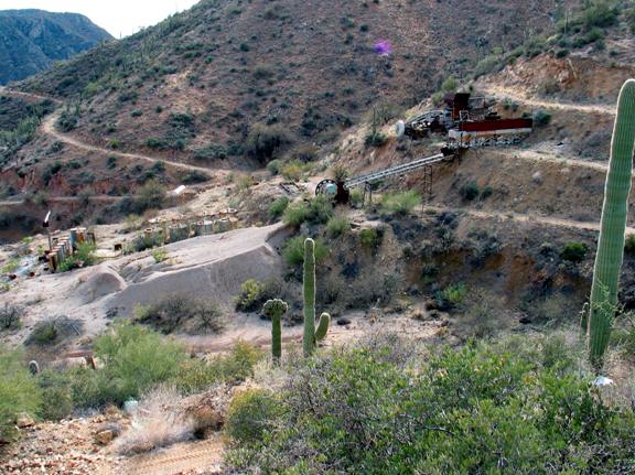
Acquisition Mine c. 2007
Photograph courtesy: Bruce Colbert
Champie Baby Grave
Pug Dalton met some really old people that came up one day,
when we were building that mill at Mrs. Losee’s and you know there was about
thirty of us there working and you know all the old people there, and nobody
would go talk to him and I closed the whole operation down, I shut down and
went over there and talked to him. And they told me if you go building here,
and they were from the Champie’s and they directed Joe Stocks to the grave and Joe relayed the information
to me and I went up and reclaimed a little baby, somebody that had got bit by a
scorpion when they was a baby.
Pug stated: Everything I’m saying is just what people have
said to me and I don’t know how true any of it is. The one thing I do know on
that grave, is there was old people (Champie family) and that’s where they told
Joe Stocks it was and he gave me the directions to the
location.
We sat that stone on the kitchen table at the Walters house
at Columbia, we must have worked on it
for a week or two. We ground on that marker with a Dremel Tool if I recall
correctly, we had the born date and death date and can’t remember the first
name but I remember it was a Champie.
Newt (White) had me go into meet Joe (Champie) one
time. Newt kind of . . . before they started doing that
mining at the Humbug . . . you know, I took those people the
samples to get them interested to go up in there to Newt. They were supposed to buy
Newt a pickup.
Figure 27
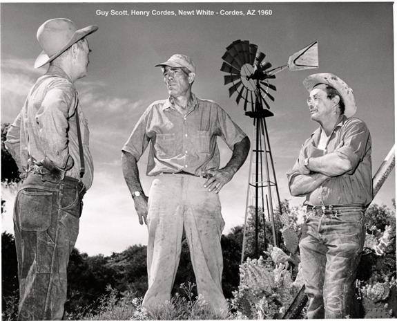
Photograph courtesy: Cathy Cordes
Guy Scott, Henry Cordes, Newt White at Cordes,
Arizona c. 1960
Newt didn’t want them to go in there, you know I
talked to him and you know . . . but I used to go over there to Newt all the time to check on him . . . chuckle . .
. Did you get any stories about Newt, he was a treat now.
Newt helped run those power lines in there through
Cordes. He was on the crew that brought that power in there.
Newt’s Typical Breakfast
Newt would eat a pound of bacon, and I think it was eight
eggs every morning for breakfast.
Newt’s Small Shot
In the evenings he’d have a small shot. One evening I went
over to Humbug to check on him and he asked me if I wanted a
small shot with him?
I said to Newt “A shot, you don’t drink do you?” Newt said “I like to have a small shot in the
evening” so I said “I guess if it’s a small one I’ll have a small one with
you”. Chuckle . . . he grabbed his cane and said “this here stuff, is the stuff
I share with people that come by that like to drink my whiskey”.
Figure 28
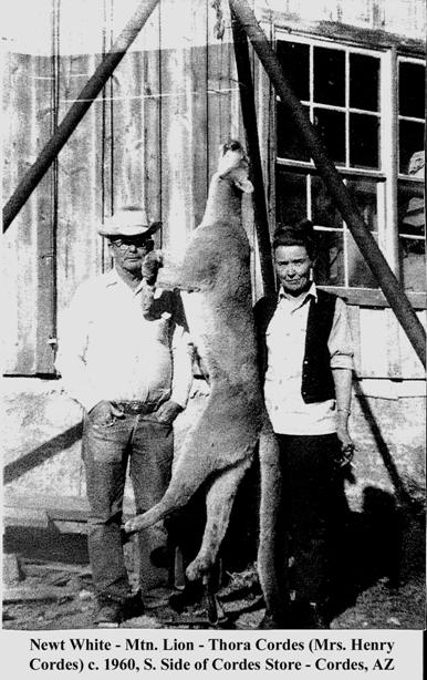
Then he said “over here though, is my special stuff”. He had
this other stuff – gallons of it – he drags this out and grabs this big ole
glass, and fills it with whiskey. You know one for him and one for me, then he
put a little splash of water in it.
I said “Gosh damn Newt, what are you trying to do
kill me”. Newt said “well it’s a small shot”. Newt had one of them every night I guess. I could
hardly drive out of there after drinking my “small shot”.
Newt was a hoot, I really liked him. I caught him
hanging off the cliff one day in his pickup. He had driven off the road and he
was high centered on a boulder and he’d been setting there on his butt trying
to dig the rocks out from under his truck with his cane half the day. So I said
“Gosh dang Newt, let me give you a little
help”.
Figure 29
Newt’s artificial left leg, notice hole which was his
vault.
Photo by: Neal Du Shane
Newt’s Vault
Newt had his left prosthesis made out of wood. In it he had
a hollow place where he stored money. When he was young, he worked at the
Champie ranch when it was a dude ranch. He sometimes drove the guests to
town and brought back supplies, including cash for the guests when they would
cash checks. He carried the cash in his wooden leg.
On the left is a photograph of one of Newt’s old prosthesis.
Notice the hollowed out hole about half way up from the ankle. It is now on
display at the Cordes store, operated by Cathy Cordes. You can be sure its Newt’s as it has his vault
built in it (we checked, it was empty!)
Disrespect
There can be very disrespectful people out there . . . Like
I was telling you the old guy over by the Tip Top, I got to talk with him a
little bit one time, and there was a bunch of us headed over to the Acquisition Mine (Figure 26) and I’ve really wanted to go
back over there and talk with that guy. He was . . . well I can’t describe him.
Really a special person.
He went to town one day to get groceries and supplies, when
he come back, somebody had went in there and just tore the hell out of his
place. Stole all his guns, they even ransacked it. He was old enough they just
took him back to town, never to return to his former home again.
The only thing over there now is a small camper type trailer
that looks to be a ranch line shack for cowboys at the intersection of the
roads leading to Tip Top, Columbia, Acquisition and Packer. There is nothing left but a
shed, trailer and some corrals. In 2007 there was a Caterpillar parked there
that they evidently kept the road Tip Top Road open with.
Another time we were setting there talking with him and it
was kind of neat cause, we’d be setting there talking and all of a sudden some
type of critter would show up. He would just stop, if he was talking or who
ever was talking, he’d get up and he’d go over and if it was a bucket of grain,
you know, the mules, horses, whatever, he’d give them a bucket and he’d come
back and set down.
If he was talking when he left he would come back, he would
start his sentence exactly where he left off as if he never left. If someone
else was talking when he came back he set down and looked at them and everybody
would be talking about something different.
This happened a few times. I could tell he was a little bit
irritated about it, one time he came back and he didn’t say nothing, but when
he left he was in the middle of a sentence and he was thinking we was a bunch
of impolite individuals anyway, was the impression I was getting.
When he sat down everybody started talking something again
and I started talking about the same thing that he started when he left. I was
the only one he’d talk to after that.
He was one of the big ranchers over on the Tip Top side. That’s one of the things I said “man you
must have never mined that gold.” He got a big grin and told me “all them miners
needed something to eat, and he made his money selling them meat” . . . I think
he said he ran . . . I don’t know where I got five thousand cattle in my mind .
. . but he ran a bunch of cattle and he did damn good feeding them.
You know the Beacon Light Mine . . . ah . . . the story that Dave Burns told you,
is where George Walters was working, that’s the mine, I’ve been
wanting to go to all these years. I know exactly where it is. Well I don’t know
exactly where it is, I just know the draw where it is, and the story I got from
the Beacon Light is it’s the profits of the mine that started
the First National Bank in Phoenix.
I went up there and Dave might have heard it from Newt, because I kept going over
there to get Newt to zero me in on it and he could never do it.
I ended up talking to a cowboy one year and he ended up telling me where it
was.
I’ve looked and I know where it’s at. It’s either on the
south side of that draw or the north side of it, not sure which. But that thing
is straight up and straight down.
The guy that owned the Beacon Light had a whore house, a saloon and a boarding
house at the mouth of the mine. Them miners, when they went into that mine he
paid them when they come out and he’d get back every ounce of gold that came
out of that mine. It was such a horrible place to get to, once you got there
was absolutely no place to go. He had the whore house and saloon where the
miners would get drunk, go to bed. The next day they’d be broke and they’d walk
in there and do it all over again.
There are mines up there all over the place. I went in on
one day with my cigarette lighter and I went in that thing and kept flipping
the lighter on – I don’t know how far I walked in it but I turned around and
all I could see is a pin hole for light at the end. I got to thinking what in
the hell am I doing?
I went in another mine up there and the whole damn place
started shacking and it was full of snakes. I knew there was something alive in
it when I found it. Next day I went back with a light and I figured it was
going to be pigs. All night I was thinking when I go in there and if I run into
some pigs, I’ll stand up against the wall and shine my light down the drift to
show them the way out.
All the time I’m thinking pigs and I’ve been walking past snakes,
they were everywhere! What an idiot.
I guarantee you, the miners that were working those mines
that rock was so hard, I sat there hacking it with a rock pick and I couldn’t
hardly get a flint piece off of it. All I could get is sparks I can tell you
those guys up there had a lot of salt in there systems.
Figure 30
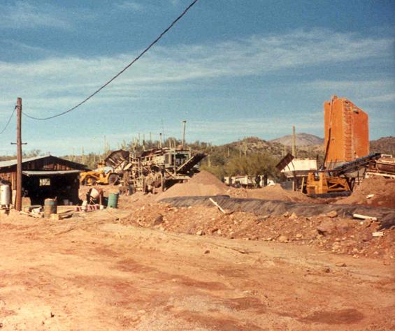
Photo courtesy: Arizona Department of Mines and
Mineral Resources
Columbia test sample
shed, crushing plant, cement bin, Agglomerator. c. 1980’s - 1990’s
There is this story the Pug tells about mining for gold:
This old prospector coming down the hill from the Mountain.
He’s got his mule, picks, shovels, bed roll etc.
He meets this young miner at the bottom of the hill with his
mule, picks, shovels, bed roll headed up the mountain.
The old miner says “howdy there partner, where you headed?”
The young miner points at the mountain and says “there is
gold in them hills.”
As the old miner walk’s away he turns and says “there’s
honey in road apples too but it take’s a bee to get it.”
By Dave Burns
Newt (Figure 27) ran away from home in 1922 when he was 14.
His father was ruthless, who took him out of school and put him to work in
a saw mill for 90 cents a day, then took Newt’s pay. Newt came to Arizona to
become a cowboy, went to work for Charlie Champie at his ranch on French Creek. Became a pretty good wrangler,
and was riding the rough stock.
When Newt was 16, he was riding far from the Champie ranch
when his horse spooked and threw him. He had a lariat around the saddle
horn, his foot got caught in it, and he was dragged and stomped quite a
distance, through Cholla cactus and rocks. His horse came back to the
ranch without him, and they had to track him to find him. So he lay there
all day, mostly unconscious, until they found him in early evening.
They packed him into Phoenix to Good Samaritan Hospital. The left leg was
stomped too badly to be saved. He eventually recovered, got most of the
Cholla thorns out, and got a wooden leg. He didn't let it slow him down much.
I asked him once how he mounted a horse, with his left leg like that. He
said he just grabbed the saddle horn and jumped into the saddle, simple as
that.
He got a job as a mill operator I think it was at the
Constellation Mine near Yarnell or Wickenburg. After
working there a few months, he asked for Saturday off. When asked why,
Newt said he needed to get his leg worked on.
The foreman said that if he had known that Newt had a wooden
leg, he never would have hired him. But he won't pass up another one. Newt was
the best mill operator they had ever had.
His leg did keep him out of World War II.
I remember a couple of Tip Top stories Newt related to me.
Newt worked with the cyanide process there. I think
they were removing pillars in the mine and reprocessing tailings. He
talked about going in the mine when they were pumping out the water.
When it came time to shut the mine down, he had noticed that
the tank rakes wouldn't go all the way down, and measured the depth of the
solution. Turned out there was a substantial buildup of concentrates in the
bottom of the tanks. They tested very rich. A final big profit was
made by cutting holes in the bottoms of the tanks and removing the
concentrates. I always wondered if he had kept his mouth shut he could
have come back later and got rich. Guess that just wasn't Newt’s way.
He must have worked occasionally as cook. He told about when the game
warden stopped by one day. He was cutting the tops off carrots, tossing
them out the back door, while talking with the warden. The warden looked
out the door and saw a deer eating the tops. "Guess there isn't much
poaching going on around here," said the warden.
Courtesy: “Ranch Trails and Short Tales” by:
Claire Champie Cordes
Edward Newton White’s grandfather was a scout on a wagon
train from Missouri across the Oregon Trail, finally landing in Lowell Range,
Oregon. They had many close calls
with the Indians; for many days they were afraid to build a fire. At night the
wagons would form a circle and the animals and people stayed in the center for
protection.
When they arrived in Lowell, Grandfather White married the girl he had admired all along the
trail, Sally Hobbs, and Irish-German girl. From
this union, eighteen children where born, the last was Newt’s father. He turned
out to be a restless, adventurous man who worked as little as possible.
After he married Newt’s mother, Newt and a sister (Annie May White, buried at Copperopolis, AZ Cemetery) were born.
Figure 31
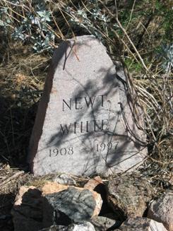
Figure 32
Figure 31. Newt White, Brother. Figure 32 Annie
May White, Sister - Headstones
Photographs and enhancement courtesy: Neal Du Shane
Figure 33
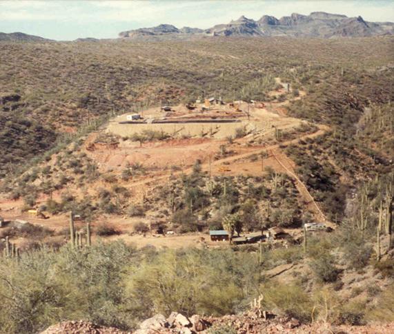
Photograph Courtesy: Arizona Department of Mines and
Mineral Resources
Columbia in foreground at bottom of hill. Ore
processing at top of hill.
Hershell M. “Curly” McKibby was 68 years old when I first
met him in 1975. I was friends with him until his death on September 8, 1985 at
the age of 76. Curly was born on May 15, 1908. His Social Security card was
issued in Michigan before 1951.
I met Curly purely by accident. I was into mining history in
the Southern Bradshaw’s as a teenager. I had hiked and stumbled across Humbug strictly by accident, hiking completely
overland, then hiked from there up to Prescott.
I had a Topographical Map and saw where there was another
ghost town by the name of Columbia just south of Humbug. It dawned on me with all the
mining activities in the area there had to be something along Humbug Creek between Columbia and Humbug.
In 1975 I went up there with a friend of mine and we hiked
that section and came around a bend and discovered Curly’s cabin and saw smoke
coming out of the chimney and couldn’t believe someone could live out there in
this remote area.
At the time I was 15 years old, he (Curly) came running out
of the cabin with a pistol, saw me . . . I was on the opposite side of Humbug Creek. Actually he came out of the
cabin without a pistol, saw me went back in the cabin and came out with the
pistol, and came splashing across the creek. I had my hands up, screaming “I
don’t mean to be trespassing, I’m just passing through!” Of course my friend
had turned around and was running in the other direction. But I wasn’t about to
turn my back on this guy, because I hadn’t done anything wrong!
Curly finally ran within 10 feet of me, and it dawned on me
he simply couldn’t hear what I was saying, I was a little bit agitated and the
octave of my voice raised I’m sure.
With all the blasting in the mines Curly had done over the
years he was hard of hearing, he just couldn’t hear me.
We struck up a friendship then and there, and became very
close friends. Then eventually I went away to college and I convinced my
university professors to allow me to come up and spend the winters with Curly,
to write about it and that’s what I did. I did that for the winters of 1979,
1980 and 1983.
Curly’s claims were the Black Rock Claim, and Red Rock Claim, I’m absolutely sure of that.
Figure 34
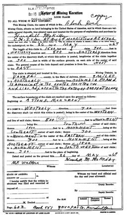
Figure 35
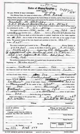
Black Rock and Red Rock Lode Claim
forms, Courtesy Troy Gillenwater
I met Newt White from time to time. Newt, you know, he was an
amazing man, I didn’t know it at the time. You know when you look back on how
you were as a teenager your perceptions change over time.
Curly didn’t really get along that well with Newt; Curly
suspected Newt was taking money from him. So I got a little bit of an
unfavorable feeling toward Newt, however now that I look back on it, I mean
even if that were true, Newt deserved it for hauling up all the groceries and
other things, that he did, just taking care of Curly. Newt was always friendly
and nice to me.
I did meet another fellow when I stumbled into the area by
the name of “Harry”.
Harry was 88 years old when I met him. He lived in a tiny “Tear Drop” trailer
in Columbia and Newt looked after him as well.
I remember when I started coming regularly to see Curly; I’d
stop by and see Harry. Every time I’d meet him I’d say “Harry how are you” and
Harry would reply “God Dammit I’m still alive”, he was mad he was still alive.
Harry couldn’t see or hear very well and didn’t have any teeth. Harry loved
birds though; Newt would bring him huge sacks of bird seed because there were
billions of quail by Harry’s house.
Harry’s trailer was up on the upper level by the main house
of the Walters. There was a period of time when there way no one there at the
main house after the Walters moved out and Harry kind of looked out for the
property.
I met George Walters sometime around 1975. I didn’t know what a
great man he was either. I knew he saw us climbing up on the western slope of
Gold Hill, he got on horse back and came on up after us, asked us what we were
doing? George was very nice and cordial and then invited us back to his house,
and his wife fixed us a wonderful breakfast. That was my only dealing with him
and his wife; he was quite old at that time.
Curly told me about George Walters shooting the person (Judge) . . . Curly was
there; at least Curly told me he was there. I think it was in the mid 1960’s. I
believe the person was a Justice of the Peace and he was drunk according to Curly.
There is a grave up on the west slope of Gold Hill of an
O.E. Perry. I could find it, it’s on the
Southwestern slope, there was a road, I’m not sure it wasn’t the main road from
Tip Top; there was a shack not far from this grave site.
Richard D. Losee confirms the grave, Dick one time was at the
structure and killed a rattlesnake. Dick was out exploring his claims, walked
into the dim and dank structure, on the inside of the stone walls were shelves
that were used for storage, sticking out about two feet from the walls. On one
of them he saw what looked like an Arizona tourist souvenir ashtray with a pink
coiled pink rattlesnake beside it.
You guessed it, the rattlesnake was for real. After Dick got
a stick and gave it a nudge, he and the rattlesnake did the double two step to
the front door then outside, Dick proceeded to shot it with his snub-nose .38
detective special with custom wooden handles, loaded with six buckshot bullets.
As Dick remembers the structure, it was made out of stone.
It sets on the right as your going up Gold Hill. As Dick recalls the structure
could have been where they kept the powder that the BLM set off in the winter
of 2007.
Troy Gillenwater continues: You know where you describe the
confluence of Humbug Creek and Rockwall Gulch. Rockwall splinters off into
Swilling and Carpenters Gulch. Right in there I build a make shift structure
when I lived with Curly those three different winters. I’ve been all over that
area and never found the Champie babies grave. That doesn’t mean it didn’t
exist but I never found it.
There was this guy that was a few years older, I’d say five
years older than me and I’m 46. He appeared out of nowhere one day and he was
strange. He stumbled into Curly and Curly didn’t much care for him. He was a
religious sort, almost a fire and brimstone type of person. There are a lot of
characters in the back country.
Spooky being where Curly was and how remote it was. You
never know who’s coming up or down the creek.
I’ll look back through my notes as I’m sure I have his name.
In fact when he found out Curly had died, he looked me up and wanted me to
finance his efforts to patent those claims for himself. He gave me a manifesto
of all these expenses, which include things like Oozy Machine-guns, it was
bazaar. I thought “Who Are You!” But then again I was pretty suspicious of
Curly in the beginning as I’m sure he was of me.
Have you run across a person by the handle “Horsethief
Thompson?” No, but that could be our
guy who was stealing the horses in Prescott and turning them in for the reward
money.
I think that’s the guy. Curly talked about him a lot. The
Horsethief Basin was named for him near Crown King.
When I was a freshman in college, I convinced this young
pretty Mormon girl to come down and meet me in Crown King. Then I hiked up from Curly's
to Crown King to meet her, then she and I hiked down to Curly’s.
This was in the winter of 1980 so it was one of the worst
floods in recorded history. The day we arrived at Curly’s it started to rain.
It didn’t stop raining for two weeks. Her parents grew concerned of course, as
she was long overdue.
Her parents some how got a hold of my father. My father was the attorney for Channel 3
television station in Phoenix. My dad somehow got Channel 3 to bring their
helicopter up to Curly’s Place to check on us.
On that morning Annie and I are in the tent and we hear this
helicopter coming through the clouds. The weather was terrible, it was raining
and it was scary. We jump out of the tent and we see this helicopter coming out
of the clouds. It was so close I could see my dad looking out the window of the
helicopter.
All of a sudden I hear gun fire, blam, blam, blam-blam and I
look up on the ridge and here is Curly kneeling firing at this thing.
Turns out Curly thought they were claim jumpers, Curly was
paranoid about claim jumpers. I run up where Curly was kneeling, I didn’t
wrestle him but grabbed the gun from him yelling “no-no-no”.
After Curly calmed down, we started talking about
helicopters, he had never seen one so close. He later asked me if I’d pick one
of those up for him. “Got To Get Me One Of Those.”
Curly never moved from his cabin. At one time Curly was
essentially squatting on the unpatented mining claims. He kept those claims
current until he died, for probably a decade after he died, I kept them
current. But eventually I tired of it and let them lapse.
Curly is actually buried on his claims . . . I found him; he
had died in his cabin. It was a very odd story. When he died, at that time he
had thirteen little dogs. When I first met him he had three little dogs,
Nipper, Kipper and Susie were their names.
Over the years he would loose one of the dogs to a mountain
lion or they would just disappear so my father brought him up a male or a
female, the opposite sex of the dog he had still surviving. They had this
tremendous amount of off spring.
What would typically happen, is that I would walk up to
Curly’s cabin and I’d call out to him, the dogs would come running out, and
he’d come running out with the pistol, he couldn’t see very well so I’d call
out to him and as soon as he’d recognize my voice he was fine, he’d put the gun
away.
One day I went up to Curly’s Place, the dogs came running out
but Curly doesn’t. I knew something bad had happened. I had also been thinking
about this exact situation, how was it going to be when and if, I found him?
At this point in Curly's life I was only up there every
month in a half to two months. I thought how horrible it would be, to find him,
if he had died a month and a half earlier.
It was September 8, 1985 at about 4:00 PM. Long shadows were
already cast upon the ground when I discovered him.
As it happened I walked up to the cabin and peaked inside,
he was lying there face down on his bed. I went inside the cabin and I went
over to him, there was a hot cup of coffee, on the table next to him . . . he
was dead. I’m not convinced he didn’t hear me coming. I’m not sure how it
happened but he had just died within minutes of my arrival.
I hiked back out to Columbia, then drove to Castle Hot Spring
resort and awoke Bud and Dorothy Mullins and called the Sheriff’s Department. Whenever
someone dies like that, they have to have an inquest. I waited until about 3 in
the morning for the Sheriff’s Deputies to arrive. Then we drove back to
Columbia and hiked back up the creek and retrieved the body.
Curly was taken to Prescott and cremated. I retrieved his
ashes in a cardboard box from the Yavapai County Coroner. We buried Curly’s
ashes on his claims near his cabin, at the foot of his favorite Saguaro. For a
burial urn, we used Curly’s “Lucky” mining pan. We waited for sunset, and then
a friend of mine played Neil Young’s “Old Man” as the sun went
over the horizon. Since Curly rolled his own cigarettes and stored Jack
Daniel’s whiskey for special occasions, each of us at
the funeral rolled and smoked one of Curly’s cigarettes, took a pull on his
last bottle of whiskey and spoke a few words. Afterwards, we had a giant party
out there at his cabin. I must say it was the most meaningful funeral I have
ever attended.
I rounded up all the dogs and took them to a kennel in Tempe
where the owner tried to adopt them out. After several months went by without
any takers, I called a local television station, went on the air and told the
story of Curly and his dogs. Within five minutes after the program aired,
all thirteen dogs were spoken for!
Figure 36
Courtesy: Troy Gillenwater
the daily utah
CHRONICLE
Tuesday May 28, 1981
Editor’s note: Troy Gillenwater, a University English major, has a favorite
hermit in the Arizona desert from which stories flow abundantly. Following is
Gillenwater’s account of his encounter with “Curly,” an area hermit and
goldminer.
By Troy Gillenwater, Special to the Chronicle
In early spring he’ll find gila
monsters sneaking into his rock cabin searching for food. In early fall come
the rattlesnakes. The slither in at night, seeking warmth from his cast iron
stove which fills the cabin with scent of burning mesquite. Scorpions and
tarantulas and centipedes – he’s found them, too. The crawl on his mattress,
hide in his shoes and between the rocks in the cabin’s jigsaw-like stone walls.
His name is Curly, and he’s a
goldminer. He is also a hermit and lives isolated in a desert wilderness.
A half century ago, as a young
man prospecting for gold, Curly first wandered into the cactus-covered Southern
Bradshaw Mountains of Arizona.
He hasn’t come out since.
I first met Curly by chance. I
was looking for abandoned mines, ghost camps and old graveyards – they’re
everywhere in the Bradshaw Mountains – and I hiked into a secluded ravine. There on
a bank of a small creek I met the old man.
That was more than three years ago.
But just last winter I went into the Bradshaw Mountains to live. I lived near the old prospector and
shared with him the desert wilderness he says he’ll never leave. And it was
like stepping into a time warp. As if time within the rugged canyons and
granite-hewed desert peaks was somehow slower, somehow a hundred years behind
what was happening out beyond the mountains. I was living among the
rattlesnakes and mountain lions. The ocotillo and palo verde. Washing and
drinking from creeks, cooking over a fire. I never traveled without a sidearm
in the Bradshaw Mountains.
I built my cabin on a small flat
just downstream from Curly’s. According to the old man, a character called
Horsethief Thompson had once lived there too, but that was a
hundred years earlier. Curly said Horsethief Thompson was having some trouble
with the territorial law so he chose to give up his horse-stealing and try to
settle down. I remember Curly explaining with a wry grin, “Well . . . Ol’
Horsethief, why he never stoled a damned horse in all his life. Maybe he
borrowed a few illegally, but he never stoled nothin.”
And Curly told me more, in fact
for three months, acting as an interpreter of sorts, he explained the way of
the desert, of its strange inhabitants, and of it weird, succulent plantforms –
the cactus.
Figure 37

Hershell M. “Curly” McKibby, c. 1980’s courtesy: Troy
Gillenwater
Curly showed me which cacti bear edible fruit – the
prickly pear and saguaro – and which cacti contain the most accessible water
for survival – the barrel. I learned that if you’re hiking through the desert
and unsure of directions, find a compass barrel cactus and look which way its
leaning. “Thems always point a feller southwest.” he promised. Freshly ground
mesquite beans make a good meal and dried saguaro ribs make good fire starters.
Green mesquite wood burns the longest, catclaw burns the hottest. He showed me
how to pan for gold, how to cure and jerk deer meant, and I think most import,
he showed me how to take the desert as it is.
Curly introduced me to the gila
monster, a large venomous lizard that
sometimes grows up to two feet long. Its size alone is frightening, but once I
saw the lizard’s beaded orange and black skin, I understood why it’s called a
gila monster. They look like
monsters, but despite their appearance, and their bite, Curly calls them his
pets. He has two of them which visit in spring. Once during an unusually warm
March afternoon, Curly and I were eating quail stew when the two gila monster
crawled inside the cabin. I heard hissing sounds and saw the lizards wiggling
across the rock floor. My first reaction was to run. Me second reactions was to
run faster. Then Curly told me what to do. “Just set still . . . thems ain’t
gonna bother ye none.” But I watched suspiciously as they zigzagged around the
cabin, peeking into crevices in the rock walls and crawling under the old man’s
cot. They hissed a lot, spitting out their long and narrow tongues, but soon
they slithered back out the door. Curly
finished his stew.
Rattlesnakes don’t bother Curly
either. He said, “That once a feller gets to know ‘em . . . hell, thems aint so
bad. Why I’ve even hand ‘em hibernatin’ in me walls. Them rattlers keep the
pack rats an’ other varmints away from me cabin.” Curly invited me to come
visit in the summer when the rattlesnakes are all over. “Thems make for a
pretty good feed,” he said.
We talked a lot. And listening to
Curly was like reading from a book of Arizona history, except even better.
Better because somehow while hiking along a certain mountain ridge and knowing
what happened in that canyon down there, or on that creek below, it gave me a
better feeling of how the 1800’ prospectors really did live and of the
hardships they encountered.
On those purple, star-clustered
nights common to Sonoran deserts, we sat outside and I listened to tales of how
Crazy Woman Canyon, Fort Misery, Rattlesnake Gulch, and Skull Valley came to be called. On a creek bank in the
1870’s a group of Frenchmen began placer mining deep in the Bradshaw Mountains despite warnings that hostile Yavapai Indians were still roaming the canyons. When the
Frenchmen discovered several rich pockets of course gold, they were so excited
they let their guard down. And that’s all it took. A band of young warriors
rushed down and it was a massacre. But as Curly tells it, one of the Frenchmen
who was left for dead actually survived. Through horribly maimed he managed to
ride mule back to Wagoner where he told of burying a Dutch oven full of
gold nuggets beneath a saguaro with three arms, one of which points north.
Several days later the victim died. The gold has never been found, but on the
west bank of a creek called French Creek, seven unmarked graves make a
person wonder.
And that’s what I liked the best
– the wondering and wandering. Many times I’d load up my pack, strap on a gun
belt and strike out. For three, sometime four or even five days I’d scrabble
over the desert mountains, weaving a path between ghost towns, abandoned
prospector’s shacks, and once, to a nameless little cemetery where graves were
eulogized by tall saguaros. One epitaph
read: “C. W. North – He Located His Last Claim”. It was the suspense and adventure, the
self-reliance that I like most while roaming through the desert.
I learned a lot out there. From Curly I learned about the desert, and
from the desert I learned about myself.
I realized that somewhere within the desert’s hostile exterior, within
its mesas, mountains and canyons, there lies a certain solitude and harmony – a
mediation between myself and the desert environment.
I never saw it clearer than one
night while sitting alone near a fire.
Gold Hill, a big mountain was to the east; a range of jagged mountain
peaks and disordered shelves, to the west.
Camping on a large flat where bits of Indian pottery were strewn
everywhere, I rolled out my sleeping bag between two boulders covered with
petroglyphs. I remember looking through
the flickering orange flames of my fire and recognizing the shapes of scorpion,
snake, lizard and bighorn sheep etched on one of the boulders. Above the fire’s leaping sparks, the
bluish-white glow of moonrise slowly emerged over Gold Hill. Coyotes started yapping. I was lonely, yet at the same time, more
content than ever before.
TO THE BLACK CANYON
HISTORICAL SOCIETY
Reprint from BCHS - Summer Newsletter – 2007
Edited by: Neal Du Shane
When Hershell
“Curly” McKibby, a Bradshaw Mountain
prospector, died at age 84, in 1983, he left all his worldly belongings to a
young college student. Sounds like an odd pairing, but when Troy Gillenwater was 15, he was out hiking through the
Bradshaw’s, approximately eleven miles west of Black Canyon City, when he saw
smoke. As he rounded the bend of the creek, in his investigation, he was
confronted by old Curly brandishing a pistol!
“You a claim
jumper?”, Curly shouted.
“No, no
absolutely not. I’m just hiking form the Columbia Mine to the Humbug Mine.” the boy responded. Gillenwater said it
took a few hours for him to convince old Curly he wasn’t there to steal
anything. What ensued was a close, eight year friendship, in which Curly traded
stories of his encounters for supplies, which Troy, his brother and their dad
would occasionally “pack” in to Curly’s cabin. Curly told Troy that before he
started bringing him his staples, he used to hike over to Rock Springs to stock up for the winter.
So, not having
any family, that anyone knew of, Curly left all his possessions, which he said
had no value, to his only real friend, Troy Gillenwater. And, Troy put everything in
boxes in his garage for over twenty years, then took them to Desert Caballeros
Western Museum in Wickenburg. They stored them for a while, but really didn’t
have the room to set up a display. So, when Gillenwater heard about the Old
Cañon School Museum in Black Canyon, he called Historical Society
president, Bob Nilles, who said he would be happy to set up a display to honor
Curly.
This was just
what Gillenwater was looking for. And, to show his appreciation, he joined the
Black Canyon Historical Society and donated $1,000.00 to help set up the
display of Curly McKibby’s life.
By: Richard D. Losee
The first day we arrived at Columbia, the gates were all locked,
signs were posted “No Trespassing”, the gates had a bell on them if you started
messing with them, high security stuff. George Walters had to let us in, when we got to the house where
the Walters lived; there is this old tear-drop type trailer parked. Basically a
two person horizontal camper, you flipped up the rear and stood outside to do
the cooking. Not more than four feet high, eight or nine feet long, Harry lived
in that trailer.
Harry basically walked the area. Harry wasn’t quite as
weathered as Curly, but Harry was always out in the sun.
Harry wore kaki short pants similar to those you wear when
you’re on a safari, that kind of a look. He always had these short tan pants,
probably the only pants he owned. He wore a Pith Helmet and he was always at
Columbia when ever
we were there. I don’t remember his last name and not sure I’d know it if you
told me what it was.
Figure 37
Setting off stored powder at the Golden Glint Mine at
Columbia, AZ. Photograph courtesy: Neal Du Shane
“Cache La Poudre” roughly translated from French means to
store or hide the powder (Poudre) in a secure, little known, not easily found,
hidden location (Cache).
It should go without saying perceived abandoned mines are
dangerous and should not be entered under any circumstances.
It is a felony to trespass on mine property. In addition to
mining equipment, materials may be stored at these remote sites with the intent
of the owner to once again work the mine at a future date.
Case in point, on February 22, 2007 at 1:19 PM, ATF and BLM coordinated setting off a Cache of blasting powder at that Golden Glint Mine. The cache of powder was
remnants of mining operations and it is believed the powder had been stored in
a secured cement vault and presumably for future use by the mine owners.
I was in the area, working on the pioneer cemeteries and
graves at Old Columbia and the Cemeteries at and around Columbia (5 in total). As I approached Columbia ore processing operation I noticed many
vehicles including a Forest Service fire truck parked at the property.
Surveying the area I didn’t see smoke or flames so figured something was up as
normally hunters don’t bring a fire truck with them.
Columbia and Humbug have become my adopted communities; I called
Larry Gill and asked if there was a party of hunters
staying at the house? Larry indicated not that he knew of but asked if I could
tell what they were doing. Said their vehicles were at the main building but I
could hear voices on Gold Hill Mountain but couldn’t see anyone. Larry asked that I go
talk to them to see if I could determine what they were doing.
A couple of people came down from Gold Hill in a side by
side, two passenger ATV, I called across the valley
and asked them to meet me at the main gate. As I waited at the gate a woman
walked up the driveway and instantly I saw the ATF logo on her t-shirt. We verbally danced for a
while with no resolve as to what they were doing and I could tell there wasn’t
going to be one either. She assured me they would be out of there within an
hour or so. I explained I was the adoptive watch dog for Columbia and the ore processing area and reported to
the caretaker’s things I observe when I’m in the area.
Went to the “T” intersection and called Larry Gill in Phoenix and explained my conversation with
her. Larry said “Oh I think I know what they are up to”. Further explaining that there was a dynamite
cement casement at the Golden Glint Mine that contained some powder and had
powder stored in it. On occasion he would use a little of the explosives in his
mining endeavors. Larry is certified and licensed to work with explosives.
Larry believes someone had been out four wheeling and discovered the cement
casement and reported it. With the heightened security since 9/11 it is
reassuring to know they do pay attention to these reports, further someone doesn’t
get hurt in an accident.
I proceed to Humbug and met with good friend Dave Burns. Dave had guests that he was
giving his historic tour, so I asked if it was okay for me to go up to the El
Pero Bonito Mine. On my way back to Humbug
from the mine, I had stopped to take pictures in a saddle of the mountain. With
camera in hand I heard a loud explosion, turning to the east I saw the plume of
dark brown smoke billowing up from the mountain side (Figure 37).
Subsequently three more blasts were observed over the next
three hours. That cache evidently was of considerable size based on the amount
of blasts that took place.
Three separate blasts were set off to accomplish the
destruction of the powder. From my perch approximately 2 miles away it was a
significant KABOOM which gave me
insight as to the conditions miners in those days had to endure (Figure 37).
There is a huge amount of information that has been lost
regarding Columbia and the claims surrounding this area, because
no one who lived there is any longer available. Some have passed away and
others we haven’t been able to locate. It is possible the family of George
Walters may have saved his papers? It is
possible the present owners, Mr. and Mrs. Losee, may have accumulated documents or claim maps
or knows someone that has historical references. Our research continues to find
additional information regarding the history of Columbia and the mines in the
area.
The road that leads up the side of the mountain on the east
side of the creek is extremely rough due to the extensive monsoon rains in
2004. In addition, the road will take you to the Tip Top road about 3 miles farther east. I’ve observed
both ends of this road and if the middle is as rough as the two ends, this is a
road to proceed with extreme caution and do it only with additional vehicles JUST IN CASE you have a problem!
In 2007, five of us traversed the road from Tip Top to Columbia on three ATV’s and one UTV. Unless you are
into rebuilding roads, going up from Columbia to Tip Top is IMPASSABLE.
From Columbia up Gold Hill the first mile has an average elevation gain
of 23%. Throw in some 30% grades and two 41% grades. To equate this, for every
100 feet you travel horizontally you gain 41 feet or you climb a four story
building in 100 feet. If that isn’t challenge enough the road has washed out
with deep ruts resembling steep canyons.
Our fearless group has been dubbed “The Columbia Long Riders” after successfully coming down
this route, but that’s another story and I digress.
We wouldn’t recommend the road from Tip Top to Columbia in a 4 X 4 as it is too rough and narrow. If
you do it on an ATV or dirt bike, take ample help – you will need it! I’ve been
on extreme roads in Colorado including Black Bear Pass and Arizona and this
road tops my list. Once you commit to this road, there’s no turning back! Back
country roads in Arizona can change from day to day depending on rain and
weather conditions.
Conversely, I’ve traveled back country roads that were on the
verge of being impassable one week, then a month later ride the same route at
40 miles an hour after someone had improved and graded the route. You never
know what you will find in the back country good, bad or indifferent, be
prepared for anything. Don’t be foolish and know when to quit and turn back. No
dishonor in getting home safe and sound.
From the northwest end
of Lake Pleasant Regional Park, travel left on Castle Hot
Spring Road until Cow Creek Road, turn right, proceed until
Columbia Trail
(Approximately 10 miles on a gravel high clearance road) turn right follow this
road for approximately 3 miles. At a “T” intersection some three miles, you
have a choice, left to Humbug approximately 2 miles, right to Columbia
approximately 3/4 miles. Then follow the BLM trail down to the Humbug Creek, turn right for approximately
1/4 mile, you will cross back over to the east bank of the creek. The historic
town of Columbia rests on the west side of the creek. This is private property
on the west side of the creek please don’t trespass (Figure 2).
Figure 38
American Pioneer &
Cemetery Research Project
|
COLUMBIA CEMETERY
|
|
|
|
|
|
|
|
|
|
Yavapai County, Arizona
|
|
|
|
|
|
|
|
|
|
From Lake Pleasant, Cow Creek Rd to
Columbia Rd,
R to “T” intersection, R to GPS reading
|
|
|
|
|
|
|
|
|
|
First of three locations: Latitude N34 02.129, Longitude W112 18 691
|
|
|
|
|
|
|
|
|
|
|
BURIALS =
|
6
|
|
|
|
3/4/2007
|
|
Marker
|
SURNAME
|
FIRST NAME
|
MIDDLE NAME
|
BIRTH DATE
|
DEATH DATE
|
COMMENTS
|
|
|
|
|
|
|
|
|
|
N
|
DOE
|
Jane
|
|
Baby
|
|
Verified
interment
|
|
N
|
DOE
|
Jane
|
|
|
|
Verified
interment
|
|
N
|
DOE
|
John
|
|
|
|
Verified
interment
|
|
N
|
DOE
|
John
|
|
|
|
Verified
interment
|
|
N
|
DOE
|
John
|
|
|
|
Verified
interment
|
|
N
|
PERRY
|
Orville
|
E
|
Sep.
9, 1874
|
Feb.
17, 1955
|
Un-Verified
interment
|
|
6
|
|
|
|
|
|
|
|
2nd burial: E. of Humbug Creek - S. of Columbia Cemetery - Approx.
40' past gate & cattle guard on right side of road leading up the
mountain - In March of 2006 a headstone & metal enclosure remains.
Possibly there are other (4 or 5) burials outside this metal enclosure.
|
|
Second Location: Latitude N34 1.979, Longitude W112 18.534
|
|
|
BURIALS =
|
1
|
|
|
|
|
|
Y
|
NORTH
|
C.
|
W.
|
1867
|
2/14/1934
|
"Location
of His Last Claim"
|
|
1
|
|
|
|
|
|
|
|
RESEARCH:
|
Dave Burns, Gene Simonds, Larry Gill, Reba Wells Grandrud, Cathy Johnson, Teri Thorpe, Neal Du Shane
|
|
|
|
|
|
|
|
|
|
3rd burial: On left side of driveway
leading to the main gate. This is of a teen-age person or a small adult. Area
is enclosed with rock marking the burial - no headstone or marker was found.
|
|
Third Location: Latitude N34 02.093, Longitude W112 18.891
|
|
|
Burials =
|
1
|
|
|
|
|
|
N
|
DOE
|
John
|
|
|
|
No information
|
|
|
|
|
|
|
|
|
|
RESEARCH:
|
Larry & Betty
Gill, Dave Burns, Neal Du Shane
|
|
|
|
|
|
|
|
|
|
Contributor: Neal Du Shane
|
|
|
|
|
|
|
|
|
|
Material may be
freely used but not changed for in any way, by non-commercial entities, as
long as this message remains on all copied
|
|
material AND
permission is obtained from the contributor of the file.
|
|
|
|
|
|
|
|
|
|
These electronic
pages may NOT be reproduced in any format for profit
|
|
or presentation by
other organizations. Persons or organizations
|
|
desiring to use this
material for non-commercial purposes, MUST obtain the written consent of the
contributor, or the legal
|
|
representative of
the submitter, and contact the archivist with
|
|
proof of this
consent.
|
|
|
|
|
|
|
|
|
|
This file was contributed for free use.
|
|
Contributor/Archives by: Neal Du Shane - ©
All rights reserved
|
|
n.j.dushane@comcast.net
|
|
|
CHAMPIE MILL CEMETERY
|
Arizona Pioneer & Cemetery Research Project
|
|
CHAMPIE MILL Cemetery
|
|
A.K.A. ALLEN'S MILL Cemetery
|
|
|
|
|
|
|
|
|
|
Yavapai County, Arizona
|
|
|
|
|
|
|
|
|
|
From Lake Pleasant, Cow Creek Rd to Columbia Trail,
R to "T" intersection, R to GPS reading
|
|
|
|
|
|
|
|
|
|
Latitude N34 02 32.00, Longitude W112 18 32.70 (WGS84) Elv. 2,283
|
|
|
|
|
|
|
|
|
|
|
Burials =
|
19
|
|
|
|
11/7/2007
|
|
Marker
|
SURNAME
|
FIRST NAME
|
MIDDLE NAME
|
BIRTH DATE
|
DEATH DATE
|
COMMENTS
|
|
|
|
|
|
|
|
|
|
Y
|
McKIBBY
|
Hershell
"Curly"
|
M.
|
May 15, 1908
|
Sep. 8, 1986
|
Hermit
that lived in this area for over 60 years.
|
|
Y
|
CHAMPIE
|
Joseph
|
C.?
|
Feb 20,
1894
|
Sep. 19,
1898
|
Male
child that was stung several times with a scorpion in its diaper.
|
|
Rocks
|
DOE
|
John
|
|
|
|
Adult
male
|
|
Rocks
|
DOE
|
Jane
|
|
|
|
Adult
female
|
|
Rocks
|
DOE
|
Johnny
|
|
|
|
Child
male
|
|
Rocks
|
DOE
|
Jannie
|
|
|
|
Child
female
|
|
|
|
|
|
|
|
|
|
|
19
|
|
|
|
|
|
|
|
|
|
|
|
|
|
|
NOTE:
|
On the
point of Columbia Creek and Rockwall Gulch. Currently a one mile hike to
reach the confluence of the two water sheds. A trail leads you up to the
Chample Mill Cemetery.
|
|
|
|
|
|
|
|
|
|
Contributor: Neal Du Shane,
|
|
|
|
|
|
|
|
|
|
Historian: Dave Burns, Troy Gillenwater, Rodney
"Pug" Dalton.
|
|
|
|
|
|
|
|
|
|
|
Material may be
freely used by non-commercial entities, as long as this
|
|
message remains on
all copied material, AND permission is obtained from
|
|
the contributor of
the file.
|
|
|
|
|
|
|
|
|
|
|
|
|
These electronic
pages may NOT be reproduced in any format for profit
|
|
or presentation by
other organizations. Persons or organizations
|
|
desiring to use
this material for non-commercial purposes, MUST obtain
|
|
the written consent
of the contributor, OR the legal representative of
|
|
the submitter, and
contact the archivist with proof of thins consent.
|
|
|
|
|
|
|
|
|
|
|
|
|
|
|
|
|
|
|
|
|
|
|
|
|
|
This file was contributed for use of
|
|
Contributor/Archives by: Neal Du Shane - All rights reserved
|
|
n.j.dushane@comcast.net
|
NOTE: It is believed after
their cremation George & Marguerite Walters ashes were cast to the winds at their Cougar
Mine at the point on Gold Hill Mountain.
NOTE: Mr. Perry is
believed to be buried on Gold Hill. (Figure 60)
according
to Phoebe M. Baird, Newt White and Mary Jones
In 1928, there were approximately 40
permanent residents of the Castle Hot Springs community. It boasted a fine, well-equipped
wooden school building, with an average daily attendance of nine pupils. The
school was the center for social activities for the local people.
It was not the original school building
to serve the area. During the winter of 1928, a new structure was finished.
Everyone in the neighborhood, including guests at the hotel and other winter
visitors, was invited to a get-together in the school yard to celebrate its
completion. They came on horseback and were enjoying: this moonlight picnic
when a restless youngster lit a candle inside the building and accidentally
ignited the lovely new school. The resulting blaze demolished the building in
minutes.
Before the last blaze and flames died
away, a group of guests from the Castle Hot Springs Hotel agreed then and the to contribute
sufficient money for a new school building, and so funds were immediately
available to rebuild.
Doubtless the unfortunate boy who
caused the fire has never forgotten the experience as he was shunned by the
other children thereafter.
Classes the remainder of that year were
at the house next door to the school.
Until 1946, electricity was unknown in
the Castle Hot Springs area, except in a few cases where there were
small generators. In the late fall of 1946, the Central Arizona Light and Power
Co., now known
as the Arizona Public Service Co., completed
a high line, bringing in electricity. Its installation was the most arduous
undertaking by the company up to that time.
For more than 20 years, there has been
a Post Office in the home of Mrs. Pearl Champie Hurd in the house next door to the school. Mrs.
Hurd was the postmaster.
At “mail time”, the local gentry
gathered in Pearl's living room and exchanged the gossip of the day, while she
sorted the incoming mail.
In earlier days, the Post Office was
operated at the hotel. Pearl Hurd had been a pillar of the Castle Hot Springs community since 1916. She was brought in as a
young teacher by Charles and Elizabeth Champie, a pioneer ranching and mining
family.
The school well was drilled in 1946.
Before that time, water from a spring
in Ash Creek flowed through a pipeline by gravity to the
school.
The Champies came to this area in 1882.
Pearl arrived at Cast1e Hot Spring by stage, which by that time was a bus
operated by the hotel, with Shade Hardee, who lived
in Morristown, as driver.
This· was the first regular bus route
in Arizona, and was started by E. Cadwallader Smith, operator
of the hotel in 1908.
Previously guests had arrived at the
hotel by stage coach, making· a stop at Bittercreek, where the stage had a
change of horses on the 32-mile trip from the California highway. At
Bittercreek, there was a phone connected to the hotel to report if the stage
had reached the half-way house. Sometimes travelers stayed overnight at the
halfway house for a rest, continuing the journey in the morning. This
information is according to Newt White and A. M. Gold, former stage driver, who still
appears each year at the Pioneers’ Reunion in Phoenix.
The toll road from Phoenix came through
the area where Lake Pleasant is today, along, the Agua Fria River above the
mouth of Castle Creek, around Silver Mountain to Wagoner and on to Prescott and Wickenburg -- this was
the road going northwest from Phoenix.
Mrs. Hurd's arrival at Castle Hot
Springs was memorable because somehow the letters containing arrival details
went astray. She and Mrs. Fred Cordes of Glendale, one of the Champie daughters with
whom she was traveling, expected to be met by Charles Champie Jr., and
escorted to the Champie home several miles away.
Both girls were dressed in fashionable
black taffeta suits and wore high heels. When they got off the bus, there was
no one to meet them, so they started to walk down Castle Creek. They recalled
that “our feet were killing us” by the time they say Charlie Riding along in
his “City Clothes” to meet the stage to go to Phoenix, where he expected to
meet them.
He put both girls on his horse and
walked beside them the rest of the way. Pearl recalls she was wearing bright
yellow fancy garters which she bad some trouble keeping concealed.
Charlie Champie eventually became this
teacher’s husband. Some years later, he was the victim of an automobile
accident at six points in Phoenix, the corner where the fairgrounds stands.
In those days, the main business of the
Castle Hot Springs area was running cattle, raising Angora goat’s
.and "wranglin" dudes, as winter visitors used to be called. One of
our roads still is called "Dude's Hill,"
Occasionally there is a flurry of
mining activity here in gold, silver and copper, and a little "'salting”
is not unknown.
Winter visitors who visited the hotel
and dude ranches loved the region, not only for its climate but because it is
virtually the only remaining area in the state where good hotel accommodations
combined with lots of open riding country are available.
Now the hotel, after a disastrous fire
that destroyed the Palm House in 1976, no longer operates as a hotel, open
to guests. It is the property of the state -- the Talley's gift to Arizona
State University, used
primarily by groups from the University as a place to hold seminars for large
groups
The outdoor hot pools of water at the
hote1 have been formed in the mineral canyon at the site of the hot springs
flowing from rocky crevices at the rate of 400,000 gallons every 24 hours. As
the water passes over the dams and through the man-made pools, it cools from
125 degrees to 90 degrees, providing a choice of hot, medium or 90-degree water
to bath in
The Tonto Apache Indians, an
unfriendly tribe discovered the springs. Oddly enough, it is said that although
they drove other Indians away, the allowed the sick of enemy tribes to bathe in
the “medicine waters.
Castle Hot Springs is an oasis with an elevation of 1,971 feet in
a palm-shaded valley, surrounded by high mountains formations.
By act of Congress, Castle Hot Springs is one of only two places where the American
flag is permitted to fly 24 hours a day from the top of a very high mountain
overlooking this ”Shangri-La”.
It is sad after over 70 years of elite
hospitality that it is no longer open to the public,
The Champie School is in a dead end canyon bounded on the north
by French Creek and the south by Ash Creek, so named
because this creek is lined with native Arizona ash trees.
French Creek in early days had an Indian village on it, and
even today pottery chards and arrowheads can be found. The Indian village fire
was never allowed to die out. Pottery was made here, and it was an early
defense area with ruins of an Indian fort up stream. The area is above the
Davison’s ranch barn where pottery baking took place.
The "French" in the name also
has historic meaning. French placer miners worked the French Creek for gold and about every six weeks about
$40,000 worth of gold was transported to Wickenburg, and when the mining party
did not show up in town, a search party was sent out. They found all the miners
were massacred.
Soldiers followed the Indians to Bloody
Basin, so named
because of the bloody encounter, and all the offenders were killed on Skelton
Ridge except on girl about age 12. The soldiers
returned with her to Fort Whipple in Prescott, and she grew up at the Fort.
Castle Hot Springs at one time was called Bloody Springs because of Indian fighting, and because the
red rock, which is red because of iron ore, looked like it was stained with
blood.
In this area originated the famous
“Barzona"
cattle, custom-bred to adapt to rough desert mountain terrain. Development of
this crossbred strain started on the Bard Ranch in 1940. In 1948 the breeding herd was moved
to the Bard Ranch at Kirkland, the present site of all Bard Ranch operations.
Old time cattle people here include the
late George and Lawton Champie, the late
Irene Evans, late Casey
Jones, James
Norman, Mrs. G.
Bowen, Mr. and
Mrs. George Walters, Newt White, Mr. and
Mrs. Jack White, Mr. and
Mrs. Brad Johnson, Mr. and.
Mrs. Del Layton and Mr. and Mrs.. Scott Layton.
Newer Settlers are Mr. and Mrs. Cal
Sutton, Mr. and
Mrs. L. Dodd, Mr. and
Mrs. Henderson. Mr. and
Mrs. Rousow, Mr.
Freeman, Cynthia
Earl, Mr. and
Mrs. R. Hines, Mr. and
Mrs. Bill Brown, managers
of Castle Hot Springs Hotel, Mr. and Mrs. R. Bates, manager of
Davison Ranch, Mr. and
Mrs. Davison, Mr. and Mrs.
R. Hankele, Mr. and
Mrs. F. Miller, highway
maintenance man, Mr. and Mrs. J. Walker and their families. Mr. and Mrs.
Shanahan, new
arrivals and the Roberts family, and Mary M. Jones, teacher at
Champie, 1977-1978.
Today the Champie School has nine pupils and one teacher. All grades
from kindergarten to grade eight are taught in the one-room school.
The teacher lives in an apartment of
three rooms adjoining the classroom. Her kitchen serves also as school kitchen
to prepare lunch for the children. Her living room is also a “Study hall.”
Children came to school on horseback,
by family car, and some walk. Because of our location and distance, this
one-room school continues to exist because it is impossible to go to the
nearest school. We are in Yavapai County, district 14.
High school pupils drive to Wickenburg,
a 32-mile trip twice daily - - a real ordeal! - - and almost impossible if
heavy rain has washes running. Others attend and live in Phoenix during the
school week, and come home on week ends
The children at Champie are very
secure, having their brothers and sisters with them, and receive individual
instruction here. They learn to work independently and can fit in any grade
level by ability because the school is really an ideal multi-level-un-graded
classroom situation. The big kids help the little kids. It is an “extended
family.”
The school board members are Mr. N.
White, president; Mrs. C. Sutton, clerk and Miss Lola Johnson (Bard,) who
attend to the administration of the school.
Dr. E. Hunt, country
school superintendent, administers the city and rural schools of Yavapai County
and his headquarters are in the courthouse in Prescott, Arizona.
Our district pays tuition for 13 pupils
attending Wickenburg, special education and high school. We also have one
correspondent student living at a remote mine.
Because of its remoteness in the
Bradshaw Mountains, this area
is not gaining in school population. Fifty years ago, Champie had nine children
and today, 1978, we have nine children.
Our registered voters number about 45.
An estimate of our area population is
about 66 now.
Note: If early residents find errors in
this 50-year history, remember that I relied on people’s memories and sometimes
that is not completely correct. Any omissions were not deliberate.
Mary
M. Jones head teach of Champie School, 1977 -
1978
Sunday October 28, 2007
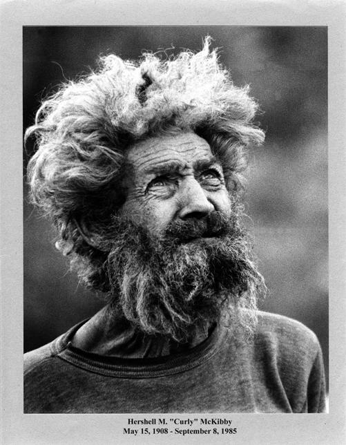
Photo courtesy: Troy
Gillenwater
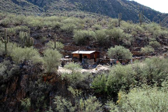
Curly’s Place on October 28, 2007 - Photo courtesy Kevin
Hart
The interest for the Columbia Stroll was more than expected. Lots of interest in
the area and specifically Hershell “Curly” McKibby and his historic former home. Referred to as
“Curly’s Place”.
The convoy from Lake Pleasant consisted of nine vehicles of
various types and we picked up 2 vehicles along the way. In total the
unofficial head count was over 30 people that made the Columbia Stroll to Curly’s Place.
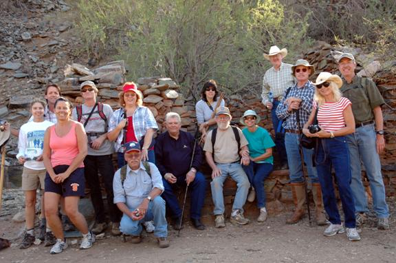
A portion of the
group of 30+ in front of historic Columbia Saloon. Oct. 28, 2007
Photo courtesy: Bruce
Colbert
We parked at the former home of George Walters, now owned by Richard D.
& Joann Losee, which was the mill site for many of the mines in this area.
The actual ghost town of Columbia sets on the banks of Humbug Creek just over the hill to the east from the mill
site. The property is currently on private land and is posted, please don’t
trespass. There is a BLM road that will take your about half way to the creek
and is so marked about a ¼ mile before reaching the locked gate to the mill
property.
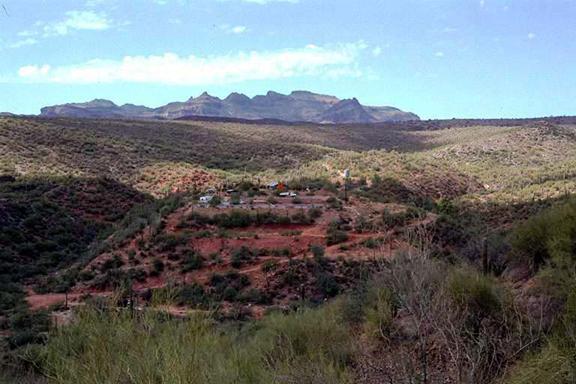
Mill with Columbia at the bottom of the picture.
Photo courtesy: Kevin
Hart
Unfortunately Larry and Betty Gill, the caretakers of this
property had come down with a 24 hour flu and asked Dave Burns the caretaker at Humbug to play host for the Columbia Stroll. Dave is a very astute
historian of this area and was an excellent guide.
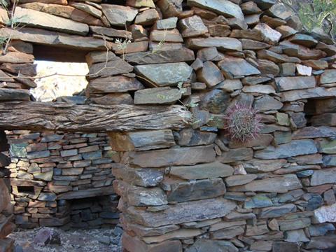
Structure at Columbia believed to be
a saloon, Photo courtesy Lee Hanchett Jr.
Starting the Columbia Stoll, historical sites were pointed out by
Dave and the remains of the Ghost Town of Columbia. Unfortunately all remaining
structures and equipment were removed by BLM some years ago. There is one stone
house and a fireplace or two still standing on the east bank of Humbug Creek across from Columbia.
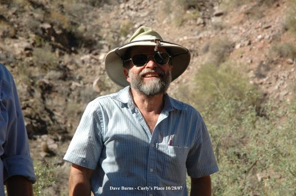
Dave Burns, Photo courtesy: Bruce Colbert
As we proceeded up Humbug Creek to the North, the original road has long since
been washed out so you walk the creek bed, which was dry when we were here.
There were various structures and mining equipment along the one mile hike that
gave reflection of prosperous years that made this area a strong but small
mining community.
It has been learned from Larry Gill that three individuals are working the creek
for gold and they have posted their claim. We saw some evidence of their
workings as we strolled to Curly’s Place.
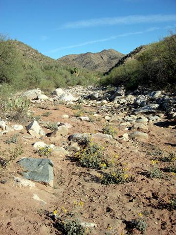
Humbug Creek, Photo courtesy: Lee Hanchett
Jr.
Early miners to this creek so named it HUMBUG as this was a
negative term, (Bah Humbug) meaning there was no or very
little gold in this creek. All the pioneer miners that worked this creek
scoffed at any hope of finding large amounts of gold here and they left the
area with empty pokes. However some amounts of rich minerals were found at
Humbug and Columbia on Gold Hill.
The Tiger and Oro Belle mines and others were large producers farther
up Humbug Creek near the beginning of the creek. Bradshaw City sat on Humbug Creek and was one of the largest
towns in Arizona at the time.
It would seem every mile or so along Humbug Creek in this area there were small grouping’s of
people, starting with the town of Humbug, Champie Mill, Columbia etc then about one mile down stream from
Columbia is another well preserved but abandoned home and mine.
Much of the mining pioneer exploration was done by Charles
Champie and his wife Elizabeth (Lizzie). Who lived at
Humbug then
Champie Mill and was involved in the development of the
Champie Ranch in the area. It is evident pioneers had to be
“Jack’s of all trades” back then to survive. They had a use for everything and
discarded little. Contrary to our “throw way society” today.
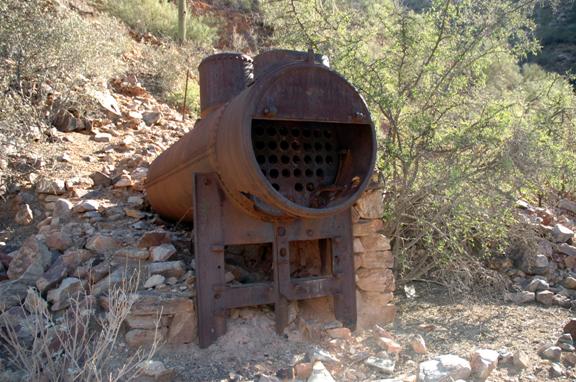
Boiler at the Lunan Mine close to Allen
Mill/Champie Mill on Humbug Creek 10/28/07
Photo courtesy: Bruce Colbert
There is still an old boiler and flywheel visible near
Allen’s Mill and in early years was referred to as Champie
Mill. There was a spring that
helped provide water for the mining operations, but little remains other than
and adobe wall and stone walls scattered about.
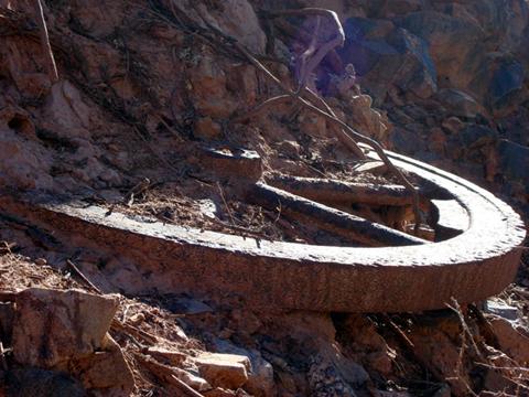
Iron flywheel at
Lunan Mine, Photo courtesy: Lee Hanchett
Jr.
The former road up to Rockwall Gulch to Swilling Gulch is still visible along the hill side and has
had no maintenance in years. The road is no longer goes through for vehicles,
possibly by hiking you could follow it to the Acquisition Mine, Tip Top, Gillett ending up at Rock Springs some 12 miles distance away. This would
retrace the route Curly went for supplies in his youth.
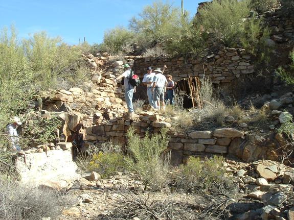
Allen’s Mill on Humbug Creek – Photo courtesy: Bob Cothern
Troy Gillenwater states that Curly was 19 when he came to this
area. Curly was born on May 15, 1908 in Michigan and lost his family in the
Typhoid Epidemic. After this incident, he went to live with an Uncle that was a
miner. They headed off to South America to seek there fame and fortune when
Curly was a young lad. Not finding it, they proceeded to Alaska and worked the
Gold Fields (presumably the Yukon Territory) then returned to California.
Crossing overland to Walsenburg, Colorado, coal was the main mining
activity there. On their sojourn they crossed over the Bradshaw Mountains and both he and his Uncle observed the mining
opportunities there. After working in the Walsenburg area they decided to head
to the Bradshaw’s.
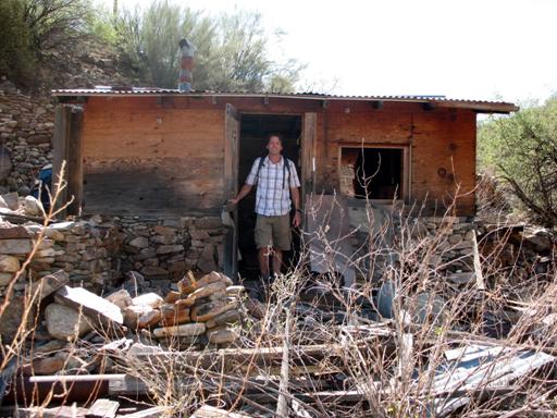
Troy Gillenwater welcoming everyone at “Curly’s Place” after 20 Years. Oct. 28,
2007
Photo Courtesy: Tom
Kenson
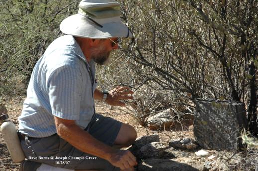
Dave Burns at Grave of Joseph Champie.
Joseph, the 8 month old
was stung to death with a scorpion in its diaper.
Photo courtesy Bruce
Colbert.
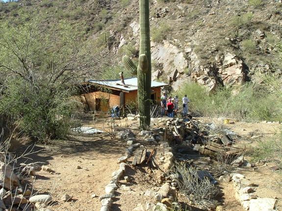
“Curly’s Place” Notice the extensive rock
work Curly engineered.
Photo courtesy: Bob
Cothern
At 19, the year would have been 1923; seven years before the
Stock Market crashed on October 29, 1929, there presumably were ample
opportunities here along Humbug Creek. Curly filed on two patented
claims, the Red Rock and Black Rock Lodes. Set up housekeeping and
exploring his claims along Humbug Creek. Curly eked out a paupers existence but
none the less would have his life no other way. Living with no electricity,
running water, bathroom, using Mesquite wood as his source for heat and cooking
he had no modern conveniences. Curly in his younger years had to hike to Rock
Springs to get supplies. He had burro’s that helped
carry his needed supplies for the trip back.
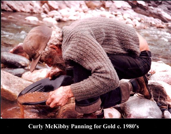
Photo courtesy: Troy
Gillenwater
We have a copy of a letter that states Curly was offered an
opportunity to live in Prescott as a ward of the County but he turned it down
to live his life as a hermit. Can’t say that I blame him after seeing his
former home along the banks of the Humbug Creek. Curly had acquired the skill
of dry wall stacking and there is evidence of his trade all over the place. A
real monument to their talents to make do with what they had in those days.
Curly it is evident was somewhat of a pack rat, which wasn’t uncommon. One
never knew when they might have use for an item. It was a full day hike to Rock
Springs and back.
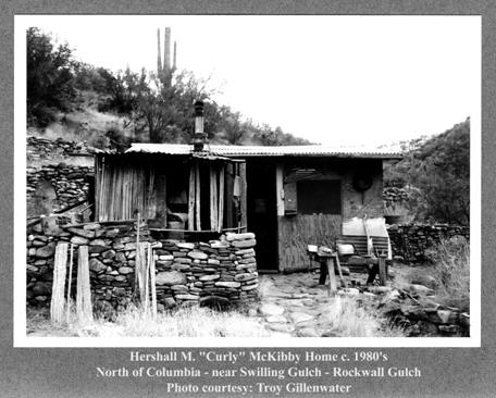
Curly’s ability to work with rock seems to have been a
love/hate affair. As an example, the floor in the house was dry laid rocks by
Curly. If for some reason one of the rocks would get misaligned and he would
stub his toe, there would be a hour long outburst of profanity that would
embarrass a Shanghi Sailor. Then extrusion of the offending rock, to which it
would take Curly hours to find the exact correct rock to replace the one that
stubbed his toe. Troy’s best advice was to stand clear of Curly when all of
this was going on.
The actual porcelain cup containing steaming hot
coffee was on the table next to Curly’s dead body when Troy Gillenwater found Curly on
September 8, 1985. It is thought that Curly expired from a heart attack moments
before Troy arrived. The cup is now on display in the Black Canyon Historical
Society.
Photo courtesy: Neal Du Shane
Troy at one time gave Curly a battery operated television.
To Troy’s knowledge it never worked. But one day when Troy arrived he could
tell Curly had something on his mind that he had to share with Troy to get it
off his chest. Curly asked Troy “remember that TV you gave me, well I decided
to fix it.” The only tool Curly had in his tool chest was a hammer. Plus factor
in Curly’s eye sight was very poor; in fact he was legally blind. Needless to
say there were bits and pieces of the TV laying everywhere. That was the
terminal demise of the TV.
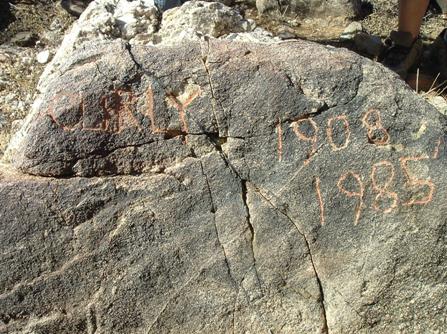
Headstone of Hershell M. “Curly” McKibby final resting
place,
Chiseled in a rock by Troy Gillenwater c. 1985-86.
It reads: “Curly 1908 – 1985”
Photo courtesy: Bob Cothern
Along the hike on Humbug Creek we discovered several graves and one historic
Pioneer Cemetery which we dubbed “Champie Mill Cemetery”. One of Charlie and Lizzie
Champie’s children, 8 month old
Joseph Champie, was stung by a scorpion in
its diaper in 1898, before they could figure out why the baby was crying.
Rodney “Pug” Dalton and some of his mining associates created a
headstone as a marker for the baby at the request of the Champie family in the
1980’s.
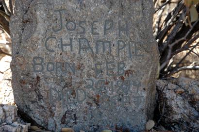
Headstone of Joseph
Champie – Photo courtesy Bruce Colbert
and enhanced by Neal
Du Shane
It reads: “Joseph
Champie Born Feb 20, 1894 Died Sept 19, 1898”
Editors Note: In 2008
Champie family members indicate Joseph
was 8 months old when he died from the Scorpion stings. The death date would be
incorrect on this marker.
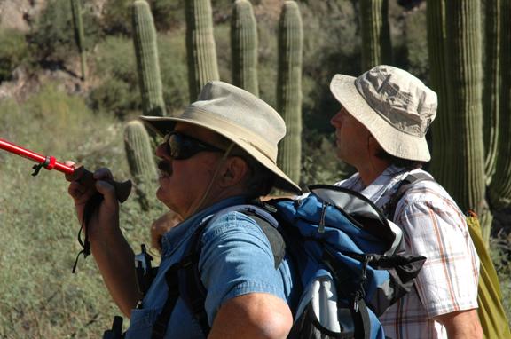
L-R, Neal Du Shane and Troy Gillenwater discuss historical events at Curly’s Place
Photo courtesy: Bruce
Colbert
My gratitude to: Dave Burns, Richard D. and Jo Ann
Losee, Betty and Larry Gill, Kay Beckman, Gary Grant, Joyce Du Shane, Bruce Colbert, Kevin Hart, Rodney “Pug” Dalton Jr., Troy
Gillenwater, Diane Bains, Bob Nilles, Bob Cothern, Tom Kenson,
Clairann Cordes Allan, Betty Hastings and Allan Hall, for
their assistance, research, contributions and cooperation in making this
project possible.
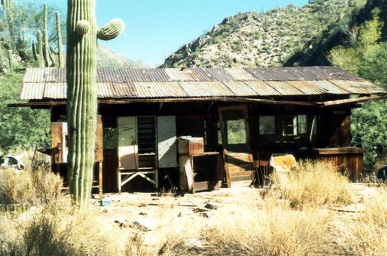
Figure 39. Cook House c. 2000.
Photograph courtesy: Kevin Hart
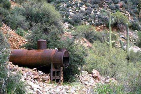
Figure 40. Boiler at mine near Columbia. Photograph courtesy: Kevin Hart
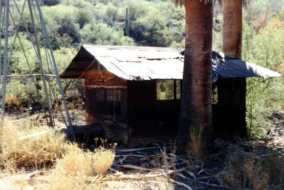
Figure 41. Building beside windmill at Columbia c 2000.
Photograph courtesy: Kevin Hart
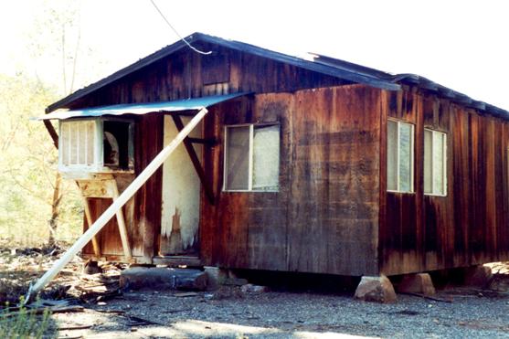
Figure 42. Bunkhouse at Columbia, AZ c. 2000. Photograph courtesy: Kevin Hart
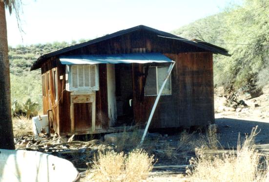
Figure 43. Bunkhouse at Columbia, AZ c. 2000. Photograph courtesy: Kevin Hart
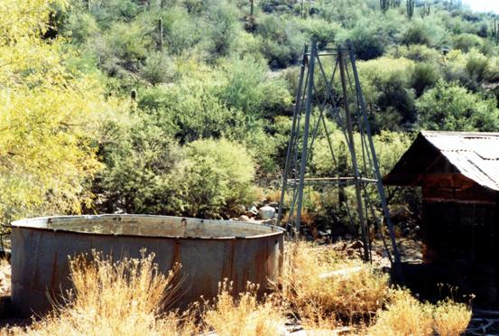
Figure 44. Windmill, water tank and shed at Columbia, AZ c. 2000. Photograph courtesy: Kevin Hart
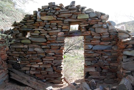
Figure 45. Post Office building at Columbia, AZ c. 2007. Photograph by: Neal Du Shane
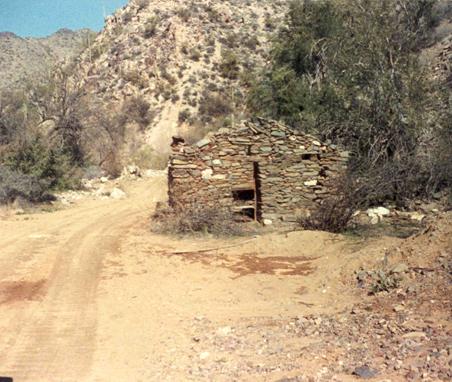
Figure 46. Photograph courtesy: Arizona Department of Mines and
Mineral Resources
Post Office - east
bank of Humbug Creek, Columbia, Arizona
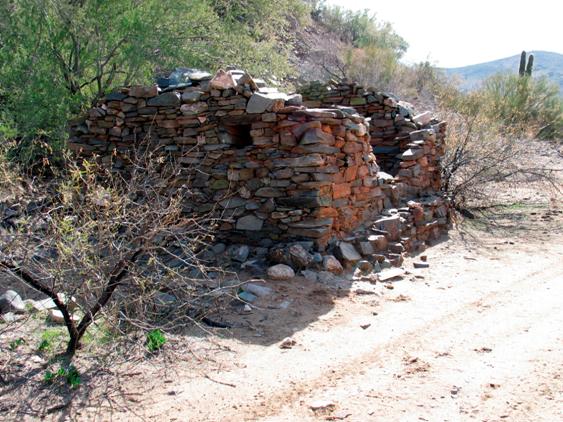
Figure 47. Post Office Columbia, Arizona. Photograph by: Neal Du Shane
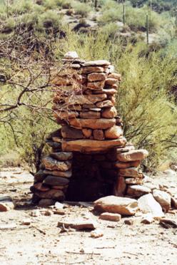
Figure 48. Fireplace of a former home in Columbia, AZ. c. 2000. Photograph courtesy: Kevin Hart
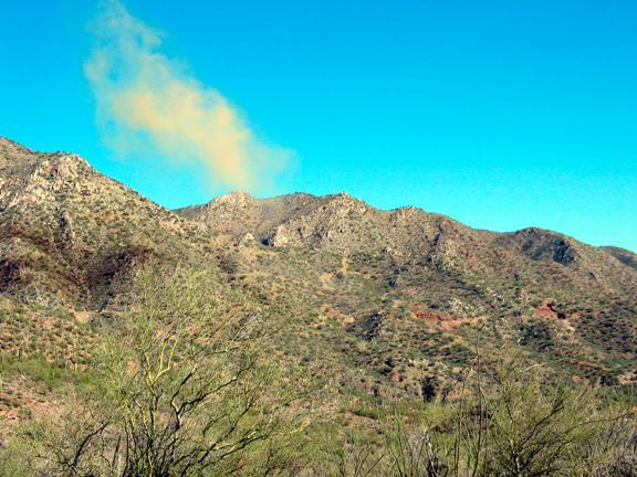
Figure 49. Exploded powder cloud from Golden Glint Mine. c.
2007 Photograph by: Neal Du Shane
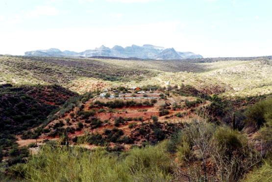
Figure 50. Mill operation above Columbia, from the Golden Glint Mine on Gold Hill Mountain c. 2000.
Photograph courtesy: Kevin Hart
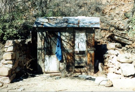
Figure 51. “Facilities” Shower on Left, Outhouse on right
Columbia, Arizona c. 2000.
Photograph courtesy: Kevin Hart
Figure 52. Water tank, windmill, building at Columbia, Arizona c. 2000. Photograph courtesy: Kevin Hart
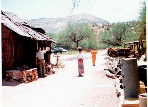
Figure 53. L-R Unknown, Jo Ann Losee, Richard D. Losee. Photograph Courtesy: Mr. & Mrs. Losee
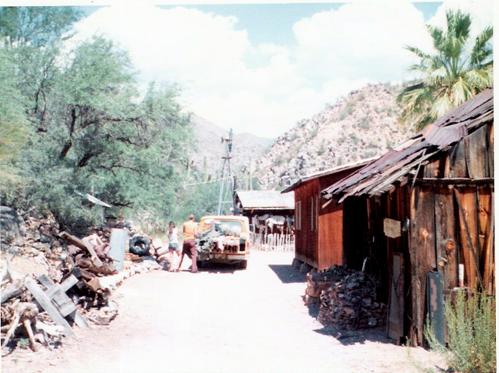
Figure 54. Looking North - Columbia’s Main St. – Windmill, cookhouse, bunkhouse, mineral
shack.
Photograph courtesy: Mr. & Mrs. Losee
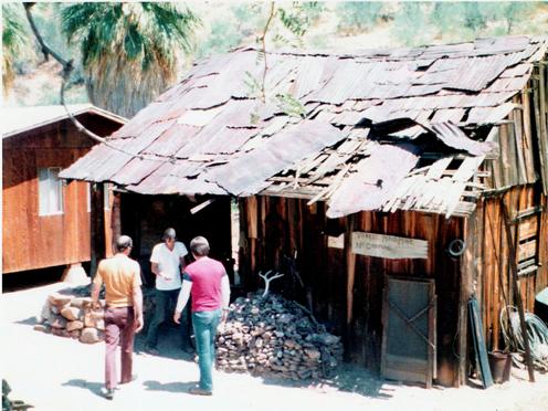
Figure 55. L-R Unknown, Unknown, Richard S. Losee
In front of the Yankee Maid office (Mineral
Shack). Photograph Courtesy: Mr. & Mrs. Losee
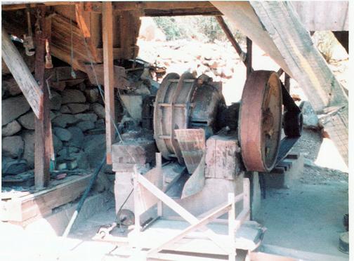
Figure 56. Ball Mill Ore crusher - Columbia, Arizona. Photograph Courtesy: Mr. & Mrs. Losee
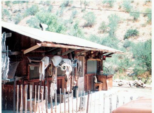
Figure 57. Cookhouse Columbia Arizona.
Photograph Courtesy: Mr. & Mrs. Losee
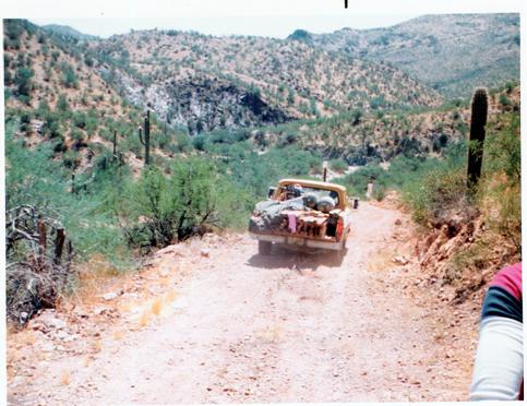
Figure 58. Coming down Gold Hill headed to
Columbia. Photograph Courtesy: Mr. & Mrs. Losee
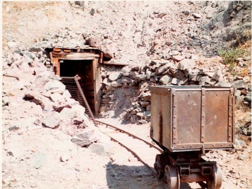
Figure 59. Hard Rock Mine, Photograph Courtesy: Mr. & Mrs.
Losee

Figure 60. Grave of O.C. Perry 1874 - 1955, Photograph
Courtesy: Mr. & Mrs. Losee
Photo enhancement by: Neal Du Shane
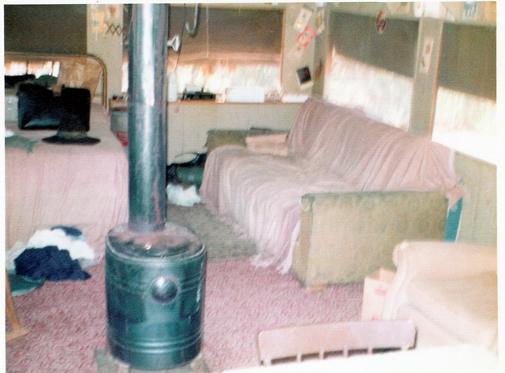
Figure 61. Interior of George Walters home.
Photograph Courtesy: Mr. & Mrs. Losee
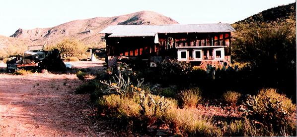
Figure 62. George Walters used this
building as a shop. Columbia, AZ.
Photograph Courtesy Mr. & Mrs. Losee
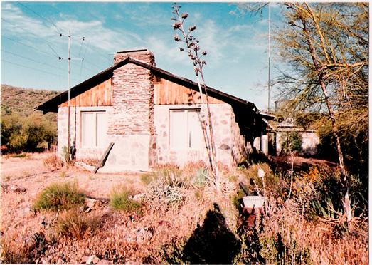
Figure 63. George and Marguerite Walters home, Columbia, AZ.
Photograph courtesy: Mr. & Mrs. Losee
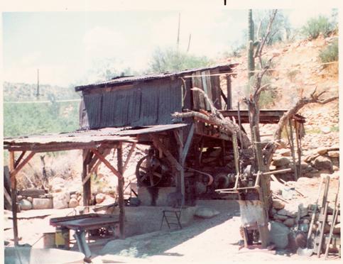
Figure 64. Ball Mill and shaker table, Columbia, Arizona
Photograph courtesy: Mr. & Mrs. Losee
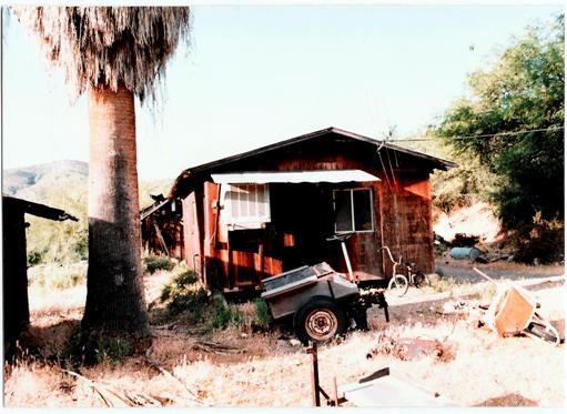
Figure 65. Single room Bunkhouse Columbia, Arizona – Photograph courtesy: Mr. & Mrs. Losee
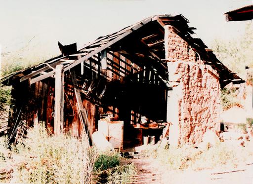
Figure 66. Mineral Shack - Columbia, Arizona
Photograph courtesy: Mr. & Mrs. Losee
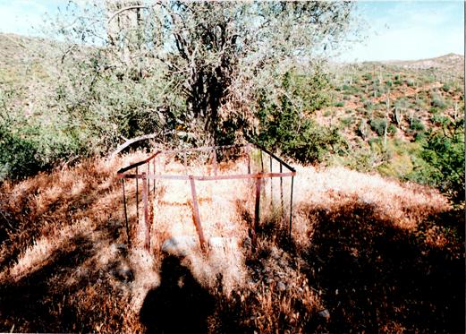
Figure 67. Grave of Col. C.W. North “His
Final Claim” Columbia, Arizona
Photograph courtesy: Mr. & Mrs. Losee
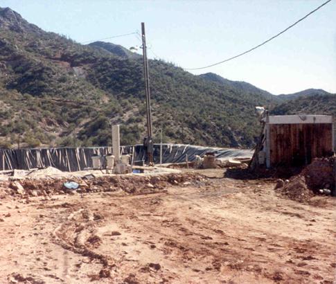
Figure 68. Photograph Courtesy: Arizona Department of Mines and
Mineral Resources
Merril, Crowe
stripper and lab. Columbia, Arizona
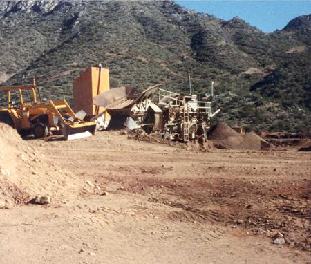
Figure 68. Photograph Courtesy: Arizona Department of Mines and
Mineral Resources
Cement bin, gravel
plant – Gold Hill in background. Columbia, Arizona
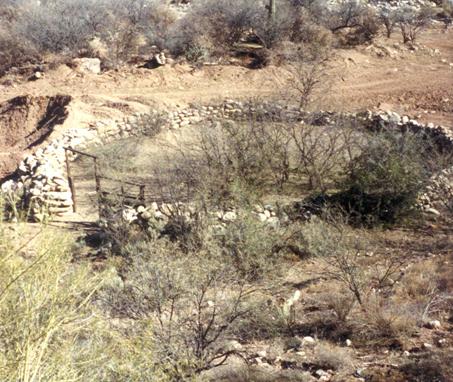
Figure 69. Photograph courtesy: Arizona Department of Mines and
Mineral Resources
Corral at Columbia, Arizona
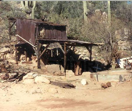
Figure 70. Photograph courtesy: Arizona Department of Mines and
Mineral Resources
Ball Mill, Columbia, Arizona
In 2007 the property and claims
at Columbia are for sale.
The main house of George Walters comprises 3.85
acres & all the remaining buildings.
There is water with a good flow.
There are 50 claims with
approximately 20 acres per claim. (Some claims overlap)
Allan, Cordes, Clairann
Arizona Department of Mines and
Mineral Resources
Arizona Pioneer & Cemetery
Research Project (APCRP)
Arizona State University
Black Canyon Historical Society
Burns, Dave: Historian – Miner –
Caretaker - APCRP
Cordes, Cathy – Historian - APCRP
Cordes, Claire Champie – Author - “Ranch Tails and Short Tales”
Dalton, Jr. Rodney “Pug” - Miner
Gill, Larry & Betty: Historian
– Miner – Caretaker - APCRP
Gillenwater, Troy – Historian –
friend of “Curly” McKibby
Grant, Gary – Historian – Pilot -
APCRP
Hall, Allan – Historian - Author –
APCRP
Hanchett Jr. Lee - Author
Hart, Kevin – Historian – Author -
APCRP
Losee, Richard D. & Jo Ann
McBride, James – Historian -
Arizona Mining
Tewksbury, Ann – Historian –
Champie Family
Zarbin, Earl – Author - The Swilling Legacy
Please visit the American Pioneer &
Cemetery Research Project Web
Sites to see other historical information on Tussock Spring, Tip Top, plus other
interesting historical information relating to Pioneer Arizona etc. at:
http://n.j.dushane.home.apcrp.org
and
http://www.apcrp.org
Columbia Master 012308.doc
American
Pioneer & Cemetery Research Project
Internet Presenation
WebMaster: Neal Du
Shane
n.j.dushane@apcrp.org
Copyright
©2003-2007 Neal Du Shane
All rights reserved. Information contained within this website may be used
for personal family history purposes, but not for financial profit of any kind.
All contents of this website are willed to the American Pioneer & Cemetery
Research Project (APCRP).
HOME | BOOSTER | CEMETERIES | EDUCATION
| GHOST TOWNS
| HEADSTONE
MINOTTO
| PICTURES
| ROADS
| JACK SWILLING
| TEN DAY TRAMPS