HOME | BOOSTER | CEMETERIES | EDUCATION | GHOST TOWNS | HEADSTONE
MINOTTO | PICTURES | ROADS | JACK SWILLING | TEN DAY TRAMPS
American Pioneer & Cemetery Research Project
Internet Presentation
Version 050109
Dry Stack Walls
– A Pioneer Legacy
By Allan Hall
The third article on Dry
Stack Walls provided photos and interpretive text on the identification and
construction of walls that can be found at mines and settlements; including
heavy walls for mining operations, corrals, retaining walls and foundations. Part Four describes walls built for the
purpose of constructing terraces.
Part Four: Terrace
Walls
Previous
articles have focused on dry stack walls that were primarily built for
transportation, mining activity and corrals.
We now turn to walls that served a much more personal need – the
construction of terraces for housing and for cemeteries. The fundamental purpose of a terrace is
to provide a flat area in terrain that is not naturally level. I submit that there are no naturally
occurring flat areas in the mountainous mining districts of
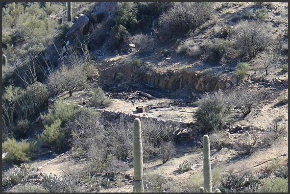
Figure 1, Terrace Wall for Buildings
The criteria I
use to classify a terrace are based on two simple, but essential, points: First, there must be an upper retaining
wall (whether natural or man-made).
Second, a lower wall must also be present.
The area between these upper and lower structures is (or was at some past time)
essentially “manufactured” flat ground. Figure
1 provides a clear example of a terrace.
In this case, the upper wall was cut into the rocky hillside and the
lower dry stack wall was constructed using shaped stone. It should be evident that the terrace
area was created by providing additional fill soil.
This terrace provided space for two houses, as evidenced by the remains
of the wood structures in the center of the photo.

Figure 2, Typical Dry Stack Terrace
Walls,
Figure 2 is possibly the best illustration I have found of a terrace wall
structure that provided a “nearly perfect” flat area.
The combined height of both walls is nearly five feet (from the bottom of
the lower wall to the top of the upper wall). Sedimentation at this site has been
effectively eliminated for more than one hundred years, even though the two
walls were constructed using irregular (unshaped) native stones. As in Figure 1, fill soil was used to
create the flat terrace.
In case you haven’t already noticed, the two walls in Figure 2 and the lower
wall in Figure 1 rise a few inches above the level of the soil. Why is this?
Take another look at the uphill side of the terrace in Figure 1, where
two things become obvious: (1) Steep
hillsides, and (2) very thin topsoil.
In fact the term “topsoil” is, practically speaking, a euphemism. Persistent exfoliation of granitic rocks
in the mountainous areas produces a loose, sandy material that is easily washed
downhill by seasonal rains where, ultimately, it is deposited in the creeks,
washes and gulches. Consequently,
the “soil” that you find on the steep hillsides is exceedingly thin and loose. The essential point is that these terrace
walls were not only constructed to provide flat areas at a point in historical
time, but to also guard against future erosion and sedimentation from the uphill
slopes.
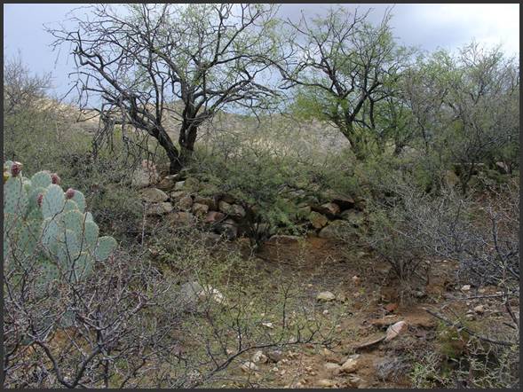
Figure 3, Terrace Wall Covered by
Foliage
Figure 3 shows a terrace wall that is only visible from a close distance. Two search methods can be used to infer
the location of walls of this type.
First, the terrace above this wall
can only be observed from a distance at a
higher elevation. I found this
wall by scanning the terrain from several hundred yards from the west and about
three hundred feet above. The
terraced area was “flat” and relatively free of vegetation – a definitive
indicator of past pioneer activity.
Second, notice the line of mesquite and acacia trees that are located on the
margin of the wall. These trees have prospered from the soil
used to create the terrace. I
believe they have also benefited from the reduced rate of runoff (that is, an
improved rate of moisture absorption).
Whenever you observe a straight line of vegetation in a remote area, you can be
reasonably certain that human activity was involved.
Naturally straight lines are exceedingly rare!
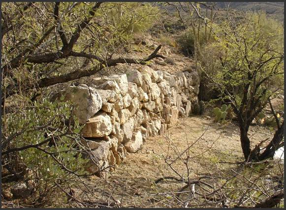
Figure 4, Cemetery Terrace Wall
Figure 4 shows a short section of terrace wall at a large pioneer cemetery. Close observation of the general slope
(from left to right) shows a steady downward incline and it is doubtful there
was any intent to create “flat” ground in the upper portion of the cemetery. Instead, this dry stack was probably
intended to mitigate erosion. There
are two additional terrace walls to the right of this photo that rendered more
level ground for graves. This wall
faces just a few degrees north of west, so it is exposed to considerable sun
light. Notice that these westward-facing rocks
have been “bleached” by a century of exposure.
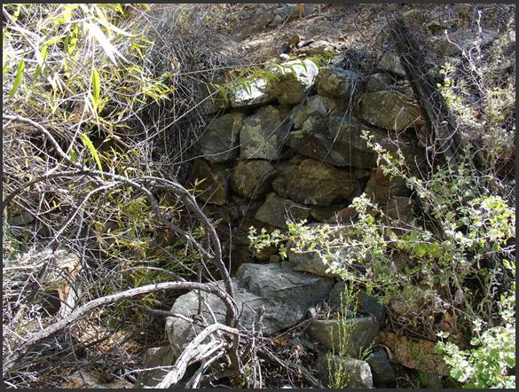
Figure 5, Cemetery Wall and Wood Post
Figure 5 shows the corner of another dry stack cemetery wall. In my experience, at least, I have found
very few derelict cemeteries that still have wood posts or other structures
(such as grave markers). In this
example you can see a post at the upper right that served as part of a fence
along the southern margin of the cemetery.
The wall in this photo appears to lean into the steep hillside, but it has not
been effective in preventing sedimentation.
The area between this and a lower terrace wall has seen the deposition of
several inches of soil over the decades.
It is usually a straightforward matter to infer the original purpose of a dry
stack wall, as the photos in previous articles will attest. Figure 6 shows one of the terrace walls
at the site known as the “
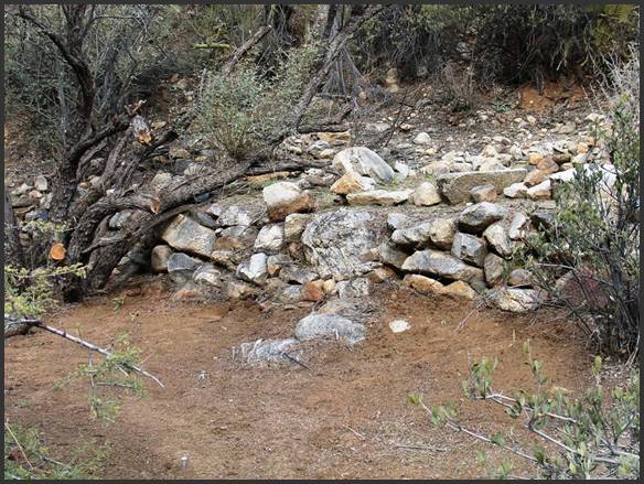
Figure 6, Terrace Wall at
This dry stack gives the appearance of having been crudely built, and that is
indeed true. Arrastres were known as
‘the poor man’s mill’ and were primarily used to “prove” the value of an ore
vein. This wall lacks the craftsmanship and
aesthetic qualities evidenced in other walls; possibly because there was no
objective beyond the immediate extraction and amalgamation of ore. While the size and weight of these stones
have kept the wall in place, the irregular shape of the rocks has allowed
sediment to flow over and through the wall in the time since it was constructed.
Notice the surface in the foreground of the photo.
It has a reddish cast and is relatively dark. Seasonal rains have steadily washed soil
from the hillside onto the terraces.
More than a century of undisturbed plant growth has been deposited on the site
and mixed into the soil by animals.
The ground slope between the upper and lower walls only became apparent after
the lower terrace was cleared of undergrowth and debris. In fact, the actual base of the wall is
more than twelve inches below the visible surface and there are at least two
more courses of rocks. This photo is
an example of why careful observation is important. If you believe you have you have located
a terrace (that is, with upper and lower dry stack walls), remember that the
purpose was to create a flat area.
If you observe a sloping surface, that is an indicator of sedimentation.
It can be challenging and, at times, frustrating to separate what you see
“today” from what a site would have looked like more than a century ago. Be patient and do not let your first
impression determine your understanding of a pioneer site. There is always more than meets the eye!
What Do These Photos
Tell You?
1.
Good craftsmanship and thoughtful placement of dry stack walls can produce
terraced spaces that will prevent erosion and sedimentation.
2.
Low terrace walls are easily masked by plant growth and can be very difficult to
locate, particularly if they are above your line of sight. However,
3.
If
you can gain advantage with elevation, the flat area behind a terrace wall will
be more easily revealed.
4.
Look for other indicators, such as straight lines of tree growth as an aid to
locating dry stack terraces.
5.
Sedimentation from slopes and soil deposition from flash flooding may mask the
height of many walls.
In Part Five, the final
article of this series, we will examine dry stack rock cabins.
American Pioneer & Cemetery Research Project
Internet Presentation
Version 050109
Copyright © 2009 Neal Du Shane
All rights reserved. Information contained within this website may be
used
for personal family history purposes, but not for financial profit of
any kind.
All contents of this website are willed to the American Pioneer &
Cemetery Research Project (APCRP).
HOME | BOOSTER | CEMETERIES | EDUCATION | GHOST TOWNS | HEADSTONE
MINOTTO | PICTURES | ROADS | JACK SWILLING | TEN DAY TRAMPS