HOME | BOOSTER | CEMETERIES | EDUCATION | GHOST TOWNS | HEADSTONE
MINOTTO | PICTURES | ROADS | JACK SWILLING | TEN DAY TRAMPS
Presentation
Version 010708

Table of Contents
Click
on hyperlinks below in BLUE –
go directly to subjects.
Speculation On The Al Francis
Name “Fort Misery”
Photo of Al Francis’s Fort Misery
Map - Ft. Misery, Kentuck’s and Burro John
Sparkling Trail From Misery to
Gold
Fort Misery Barrack’s dispelled
Fort Misery Cemetery Photo 1/3/08
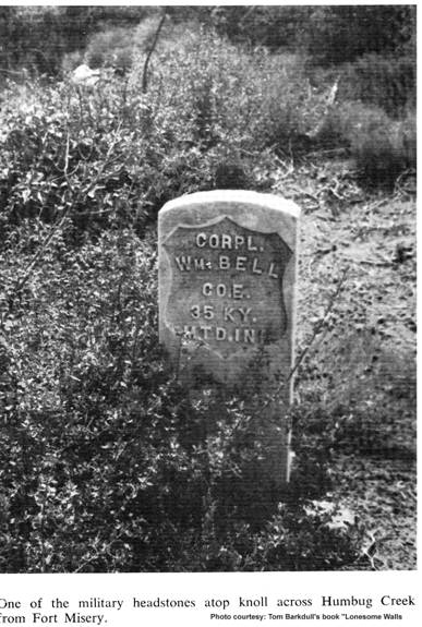
Photo of Corpl. Wm. Bell “Kentuck” marker
Kentuck’s grave - Update 1/3/07
Fort Misery is Now a Ghost Town
“Burro John” Revelos 1/3/08 Update
Speculation On Al Francis Name “Fort Misery
There is a spring near this location by the name of Misery
Spring. Knowing water was as good, or in some cases more valuable than gold in
those days, it would make sense to name this location Misery or Misery Springs.
Al Francis's who lived here it seems had a sense of humor and with tongue in
cheek, dubbed it “Fort Misery” due to his difficult and bleak living conditions
at his residence, this name stuck. Although it has been written there was a
military fort, there is no military documentation that we have found to
substantiate this. We have found a
1/4/08 Neal Du Shane: Spoke to Lloyd Clark Arizona
Historian, who has written and documented all the historic military forts in
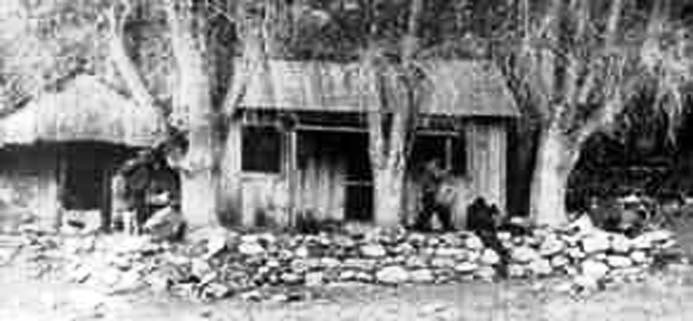
Photo of Al Francis’s Fort Misery
The residence of Al Francis
Stone structure on left still remains. Never a Military Fort
Photo courtesy: Bonnie Helten
Fort Misery
“X Marks the Place” by Byrd
Howell Granger
“Fort Misery Yavapai County elevation 5,355'
This name was given to the first house built in
Source of Photo unknown.
Historical Misnomer’s
After four years of research we have found the term “FORT”
in reference to a military fort does not to apply to any of the three locations
that were named “
Barkdull’s writing below and pictures of Barrack’s at
Often when writing historical information you have to publish the best information you have available at the time, based on the research you have done. If the author doesn’t physically visit and researched an article, they are publishing from the best information at hand by others.
At best, accuracy may only be 50% in any historical publication unless the author actually witnessed or observed the incident. What was the slant of the author when they wrote the article?
As with witnesses in an automobile accident, if five people witnessed the incident, there can be five different observations of facts. History is normally told by the person that wrote it and is only as accurate as their perception at that time. We constantly find new information relating to a historical event after years that can change it completely from what was previously written.
Billy the Kid: was believed to be left handed for years when history was written regarding his life, when if fact someone had simple reversed the photograph negative and he is actually right handed – whoops.
Custer’s Last Stand: we have all read the encounters of his heroic event, when current day technology was applied to the Little Big Horn battle ground it turns out to be a route - whoops.
Map - Ft. Misery
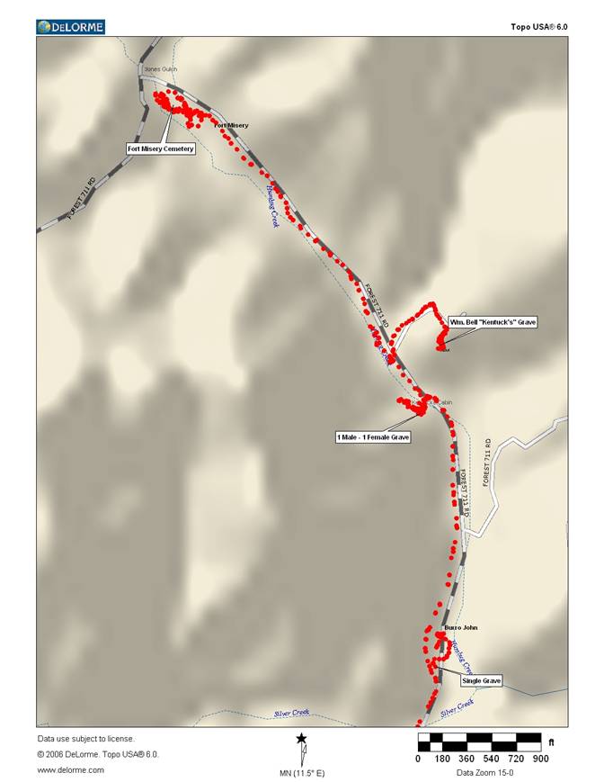
Courtesy, Author: Tom Barkdull’s book “Lonesome Walls”
Sparkling Trail From Misery to Gold
TO THE BUFFS OF WESTERN heritage -
those who follow ghost trails of our
great Southwest-the
But before you start, come with me for a preview. If you like it, maybe we'll meet in the shade of an ancient barracks or on a long-forgotten Main Street-meet to talk and dream together.
Hunkered against the
steep wall of a narrow canyon high in
Photo of
Although the site is far off beaten trails, it is easily accessible to the back-country enthusiast. Abounding with picnic and camping spots, it's truly a place to dream. Humbug Creek ripples a lullaby as it picks its way over rocks between the road and the ancient corral. The air is sweet and clean, the vegetation lush and ripe, laden with wild grapes and berries. Trees had donned their autumn colors during my visit, and the winds of change had picked gold coins from the giant cottonwoods and tossed them into the stream.
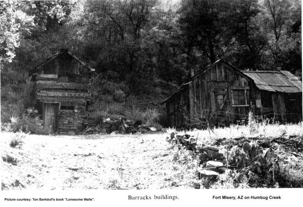
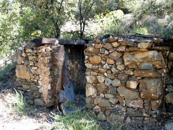
Barracks at
Old Ft.
Misery
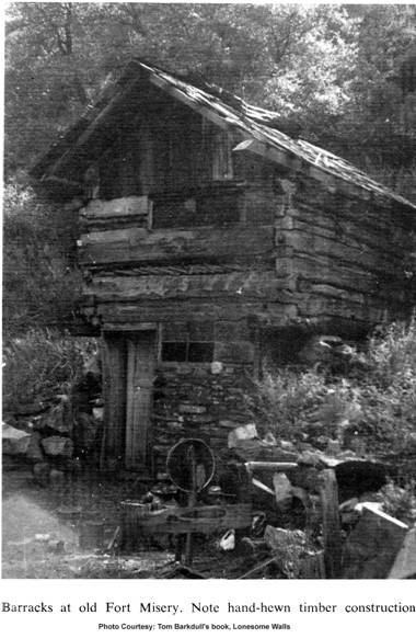
This massive structure, constructed of stone and timber, has hidden its head in the upper foliage of towering cottonwoods. A stairway, attached solidly to the outer wall, leads to the second floor, where the rooms are musty and dim.
Soft mountain breezes whimper along the hallway, stir the brittle wallpaper, then depart with a sigh through the open door at the landing.
The main floor is shady and cool. Tiny dust devils spin long-cold ashes along the huge hearth which dominates the old dining room. Silence is absolute here, broken only by the occasional rasp of a branch along the roof or the rustling escape of a swift lizard across yellowed newspapers which carpet the floor.
Outside, the street is sunny and warm. Soft air and the splash of capricious Humbug Creek make this a place for reverie. As you stroll down the old main stem unfetter your imagination. Listen to the tattling wind as it whispers through the sagging headframe high on the canyon wall above the townsite. It will tell you, if you're in tune, many tales of the lusty men who toiled for gold in the very tunnel before you, and of their gracious ladies who chatted across the picket fence just beyond the smithy.
And perhaps, if you're really a dyed-in-the-wool ghost town enthusiast, you'll imagine for just a second the tread of cavalry horses-the rattle of scabbard chains-as the brave men from the fort ride in for a night on the town.
This is the
Fort Misery
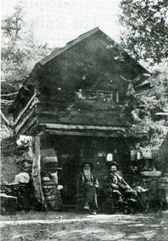
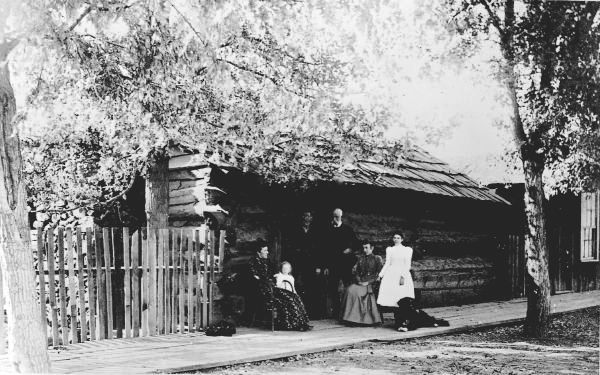
If you enlarge the photograph that Tom Barkdull calls the
“Barracks at
Facing the picture, there are two gentlemen setting in front of the structure under a roofed porch with Kentuck’s dog at the left knee of the person seated. Above the head of person on the right in the picture seated, the shiny object is a mirror mounted on the exterior wall.
We are speculating the person on the left is William
“Kentuck”
Kentuck’s Place – Kentuck on left?
Photo courtesy: Richard Pierce
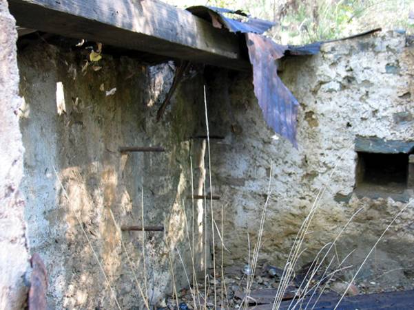
In this picture on the right is a bench in the hill side that has personal items on the shelves and a porcelain wash basin on the stone ledge. On the left of the door way is a keg with a wooden flow controller, large enough to hold several gallons of water for personal use.
On the left of the keg is a lantern mounted on the post, and Kentuck’s dainties (wash) hanging on the line. At the time this picture was taken it appears this structure was used as a residence with possibly the bedroom on the second floor – how they got to the second floor is still unknown as the first floor room isn’t logical to have a stairway as the structure isn’t large enough. We are estimating the structure foot print to be approximately 10’ X 12’. Possible there was an entrance at the rear of the second story as the embankment would elevate you to the same level as the second floor at the rear.
Fort Misery
With historical research nothing is set in concrete, even
when it is written. The controversy regarding an actual
Fort Misery Cemetery
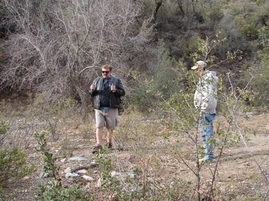
L-R, Neal Du Shane,
Darrel Steffen research the military graves at
Photo courtesy: Bonnie Helten
Always trying to keep an open mind with any research into
history, we arrived at
Time and the elements have erased all most all evidence of this cemetery. Upon close research and investigation we did locate the cemetery with up to 20 graves possible. It was exactly located as described in Tom Barkdull’s description above. Of the graves found our research found 4 graves of military solders. We did not spend a full day laying out this cemetery and identifying all the graves but this gives us reason to return for this project in the near future.
With this evidence in hand is it possible this was a outpost
of the military and not an actual fort? True the soldiers could have been
killed at one time on an expedition from somewhere else. None the less the
question remains, was there an actual
Fort Misery
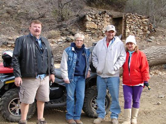
L-R, Neal Du Shane, Mary Ann Wunderlin, Darrel Steffen,
Barb Steffen not pictured Bonnie Helten & Buddy.
Photo courtesy: Bonnie Helton
William “Kentuck” Bell
Information Provided By: Richard Pierce
"William
"Kentuck"
Cause:
Brights Disease (Note: Brights Disease is a chronic kidney disorder.)
The
headline on Kentuck’s Obituary said:
"Kentuck"
A
tombstone was shipped to Crown King, and hauled to the Humbug Creek by Al
Francis. Al Francis and Burro John put the headstone on Kentuck's grave.
Kentuck lived about half way between Al and John. They must all have been good
friends.
The
stone read: "Corpl. Wm Bell, Co. E, 35th
Photo of Corpl. Wm. Bell “Kentuck” marker
Kentuck’s grave - Update
1/3/07
The descriptions in the above picture are
simply wrong. We walked up to the grave site of “Kentuck” and there is no
evidence of a headstone. We did identify his grave location and took a GPS
reading. From the above picture there is consideration by APCRP to recreate
this marker and replace it out of respect to “Kentuck” and history. It was
suggested by the group that his headstone be rebuilt and replaced at his grave
site. If you would like to participate in this restoration project please email
us.
Kentuck’s grave 1/3/08
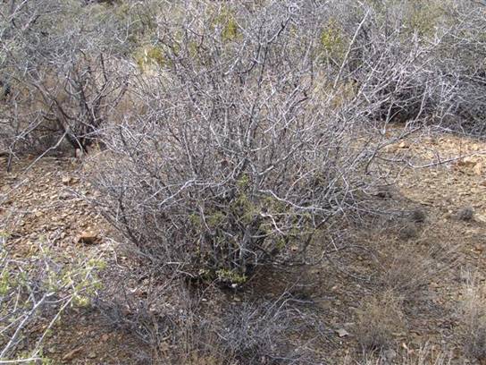
Sadly all that remains is a bush and Wm. Bell’s grave
Photo courtesy: Bonnie Helten
Proceeding back to the old structure where Kentuck lived, on topographical maps there is indications of a grave on the south side of the flat area where his cabin is. After researching the area we found two graves, one an adult male and one a teenage girl – presumably the daughter of the male. At this time nothing else is known regarding either of these graves. If you have information please forward it to APCRP so we can share it with fellow historians.
Al Francis
From
Internet – AZ Ghost Towns
Al Francis built
Al Francis Grave
12/27/07
By Neal Du Shane: The final resting
place of Al Francis has been found in the
Al Francis’s
Fort Misery
Ft. Misery
Remains of Al Francis’s Ft. Misery 2005. Photo by:
Neal Du Shane
If you compare the stone’s in Barkdull’s photograph of the
“Fort Barracks” and the stones in this photo they are not one in the same
buildings, could it be they tore down the “Barracks” in Barkdull’s building and
used the stones to construct this structure. I can see some similarity in the
rock on the left side of this structure. All of this of course is speculation
on our part and Barkdull’s photograph may have been in another location close
to
Ft. Misery
Interior of Al Francis’s
Directions to Al Francis’s
Be
advised there is another road called the “Crown
King Trail” that comes in from the south off
“Burro John”
Revelos 1/3/08 Update
The history of this area along Humbug Creek
has the residence of Burro John, Kentuck’s Place and
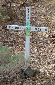
WADE grave, 1941 – 2005 at Burro John
Photo courtesy: Neal Du Shane
There is a new grave that has a white cross
in the picture above with a date burial date of 2005. If you know anything about
this grave please forward it to APCRP.
Not much remains of Burro John’s except for
the clearing between the road and creek.
APCRP
Internet Edition 2008
Compiled by: Neal Du Shane
All Rights Reserved, ©
WebMaster: Neal Du Shane
Copyright ©2003-2008 Neal Du Shane
All rights reserved. Information contained within this website may be used
for personal family history purposes, but not for financial profit of any kind.
All contents of this website are willed to Neal Du Shane APCRP.
HOME | BOOSTER | CEMETERIES | EDUCATION | GHOST TOWNS | HEADSTONE
MINOTTO | PICTURES | ROADS | JACK SWILLING | TEN DAY TRAMPS