American Pioneer & Cemetery Research Project
Internet
Presentation
Version 052409
SUPPORT APCRP
BECOME A BOOSTER
Researching a Depression Era Mine
By: Allan Hall – APCRP Certified
– Historian – Author
Photographs by: Author
Introduction
No one can
say with certainty how many adits and shafts have been dug in Arizona’s mining
districts in historic times. Estimates vary considerably – even between state
and federal agencies – but could range as high as 100,000 hard rock mine
entrances. The vast majority fall into two broad categories: “past producers” and “prospects” and nearly
all of them are now abandoned. The steady decline in gold and silver production
during the 1920’s and early 1930’s led to the closing of many mines. Settlements
were dismantled, or simply abandoned, as people moved
on to seek their livelihood elsewhere.
After the
earlier pioneer period, another wave of migration occurred following the
economic collapse and ensuing depression of the 1930’s. These were jobless and
homeless men and families. For some of them, their attraction to the mining
districts was the based upon the hope that a few ounces of gold each month
could keep them fed. For others, a lode claim provided a cheap way to live on
the land – whether there was any ore or not.1
Within a one
mile radius of Morgan Butte peak2
there are more than sixteen mine shafts and adits. If you extend your search
area to a radius of barely two and a half miles, there are several dozens of
old mines and associated settlements. Although some of them date to the late
1800’s (and a few were good producers), the majority were established in the
era that extended from the early 1900’s to the Great Depression of the 1930’s. Unfortunately,
the geology in this locale virtually guaranteed that most mines would turn out
to be a disappointment. While there were
many promising signs of ore, nature conspired to place much of it in small
pockets and seams. What might appear to be high grade ore in an exposed vein could
abruptly end after only fifty feet. More frequently, the vein contained low
grade ore that could not offset the cost of extraction and processing for a
small time operator.
Without
investors, the only way to make a go of it at a low producing mine was to have
little or no capital burden. This article will focus on a mine and small
settlement near Morgan Butte that fits this broad characterization: It was a
low producer, there was no mill or heavy equipment and, from appearances, there
was virtually no operating overhead. Moreover, the features at this mine
suggest that it worked during the 1930’s. By that time, most of the successful
mines in the area had already run their course.
A
Depression Era Mine
The subject of
this article is a mine located about .75 miles NNE of Morgan Butte (roughly 36
degrees east of true north from the peak3).
This area is literally blanketed with old (closed) and active lode mining
claims and it includes a patchwork of patented land that is now deeded to
modern day ranchers and investors.
We have
discussed on many previous occasions the use of arrastres. They were the “poor
man’s mill” – a way to cheaply pulverize silver or gold bearing rock. The rate of processing would be limited to only
a few hundred pounds of rock over a period of several days. Typically, an
arrastre would add mercury to the ore charge to produce an amalgam. The older “Mexican”
arrastres around Wickenburg were constructed using shaped stone in the walls
and floor and did not use mortar or cement. Notice the more modern style of the
arrastre at this site:
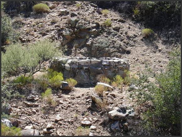
Figure 1, Depression Era Arrastre
Figure 1 shows
an arrastre that is quite tall by normal standards, but which has a relatively
narrow inner diameter. It was constructed with cement and boulders to a height
of more than three feet. The area surrounding the arrastre is still quite flat
and afforded ample space for a mule to pull the drag stone that crushed the ore
charge.
Arrastres of
this type can generally be classified as post-1900. In this example however, I
believe it dates to the 1930’s, but not more than one decade earlier. More on that subject later.
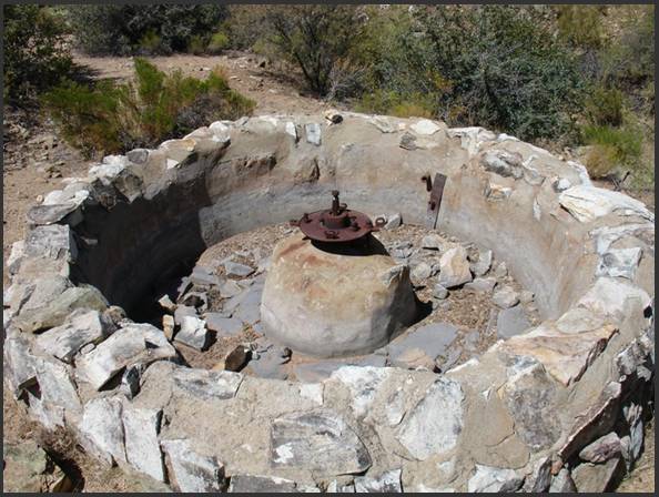
Figure 2, Top View of Arrastre
Figure 2 shows
an inside view of the arrastre. The interior wall was fully encased with cement
and the metal center post is, if anything, over engineered. The floor was built
using stonework in the traditional manner. This is probably because a cement
floor could not have withstood the abrasive effects of the drag-stone. The
width of the floor was wide enough to accommodate a single drag stone –
suggesting that only two or three hundred pounds of ore was processed during
each cycle.
There are two
particularly interesting features in the interior of the arrastre.
First, notice the two drain pipes to the right of center. The lower pipe is in
a metal plate, while the upper pipe protrudes through the wall to the left. Second,
notice the abrasion and water marks on the center column and inner wall.
There were
several steps involved in the pulverizing and amalgamation process using an
arrastre. Once the ore charge had been
thoroughly reduced to a fine sandy texture, water would be added to produce a
fluid, muddy consistency. At that point, mercury would be added and the
drag-stone operation might continue for another few days. This was a critical point in the mixing of
the ore/sand/mercury. The objective was to continually mix the components so
that amalgamation (a chemical bonding between the ore and mercury) would occur.
Finally, more
water would be added (that is, to the higher pipe) to produce a ‘soupy’ texture
while the mule would continue to pull the drag stone, but at a slower rate. This
would permit the amalgam to slowly settle to the bottom of the arrastre. The
water would then be drained away and the waste material would be scooped out. The
ore (gold or silver) would have settled on the floor, where it could be removed
and separated from the mercury.
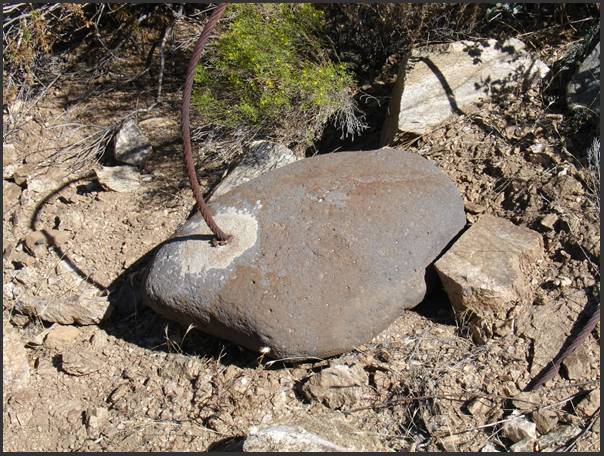
Figure 3, Drag Stone with Cable
Further
evidence that this arrastre dates to the early decades of the 1900’s is
provided in Figure 3. Notice that this
drag stone has a steel cable inserted on the top. Older, ‘Mexican’ arrastres used drag stones
that typically weighed more than 200 pounds and featured a bent iron rod
protruding from the top. I have never
seen an ‘old’ arrastre (one that can be dated to the 1800’s) that used steel
cable. Aside from the use of this more
modern feature, the drag stone does not weigh much more than 100 pounds.
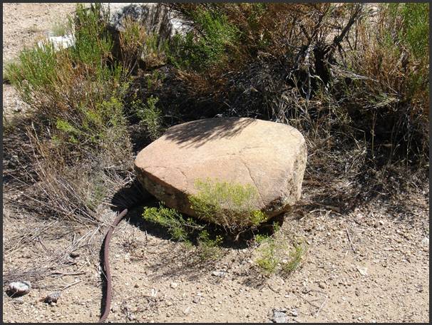
Figure 4, Another
Drag Stone with Cable
Figure 4
shows another drag stone at the arrastre. Like the previous one, it used a
steel cable to connect to the rotating arm that was pulled by a mule or horse. In
this case, the stone is nearly the width of the drag area inside the arrastre. Notice that five edge faces of this stone and the
bottom have been worn smooth from use. There are relatively few drag stones at
this site (only four that I have confirmed). Considering the relatively small
capacity of the arrastre and the nature of the mine, I believe it was not used
continuously. Otherwise, there would be more drag stones.
There are two
unanswered questions in the views of the arrastre. What was the source of water
and, importantly, did this arrastre use mercury for amalgamation?
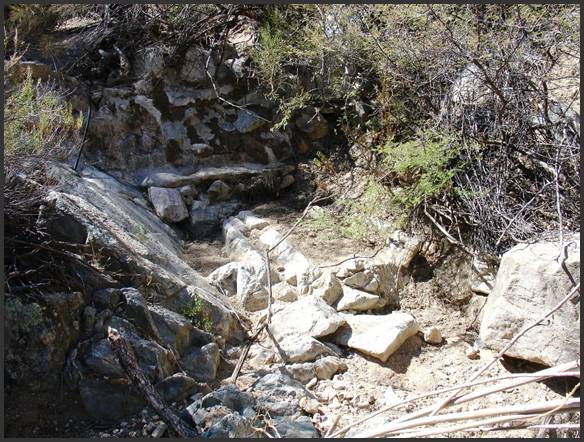
Figure 5, Wet Panning Site above Arrastre
Approximately
100 yards above the arrastre there is a rather ingenious site that was used for
separating ore from pulverized waste. Figure 5 shows a rock and cement
structure that features a high wall, a ledge, two troughs and a drainage sluice
(center of photo). This is the functional equivalent of a “panning” site that
would have used water motion to separate the heavier gold ore from the lighter
waste material. The design of this structure suggests to me that the arrastre
did not rely upon mercury for amalgamation. In other words, the arrastre
pulverized the ore bearing rocks and the “panning” site completed the
separation of ore from waster material.
Another fifty
feet or so beyond this structure there is a spring and well (perhaps more
properly described as a cistern) that collected water for the arrastre and the
washing/panning structure. See Figure 6.
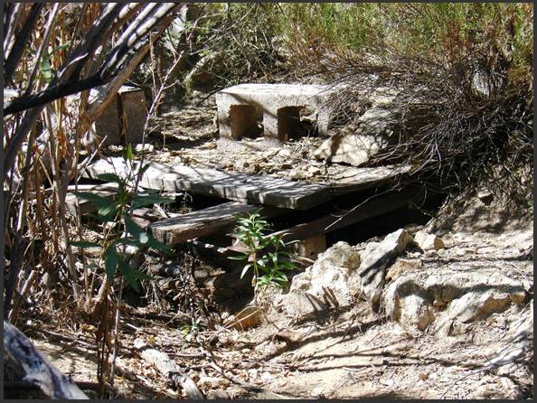
Figure 6, Well/Cistern
Today, it
serves as an occasional source of water for cattle that graze this section of
land. The rancher has protected the opening to limit the inflow of debris. Not
clearly visible, but importantly present, there is a metal ore car rail on the left
side of the well opening. A feature such as this suggests that at least one of
the three adits at this mine may have had rail tracks and an ore car. I have
found no other rails outside the mine entrances, but tracks may remain in the
interior of one or more adits.
When I examined the well site, the water level
was several feet deep and was clear. Decadal drought conditions have reduced
the flow of water, but would still provide ample volume via gravity feed to the
arrastre, panning area and modern water trough. There are old metal and modern
PCV pipes running down the gulch that show the original and modern uses of the
well. Seasonal rains certainly contribute to the water level and probably
produce some rather significant runoff in this steep and narrow gulch.
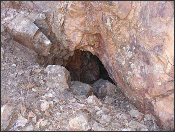
Figure 7, Upper Adit
This mine
certainly qualified as a “hard rock” operation.
As shown in Figure 7, the upper adit (one of three entrances) was dug
and blasted into a very solid face of the mountain. The adit gives an appearance of a gentle slope
in a westerly direction. The gangue pile in front of the adit indicates that a sizable
quantity of rock was removed to reach the primary ore vein. I have not entered
this adit and I do not suggest that you do, either - it may serve as habitat for
snakes and other wildlife. Furthermore, it is not possible to assess the
condition of the adit beyond the first few feet. The sizable boulders at the
entrance show that rock has sloughed off the wall above the mine.
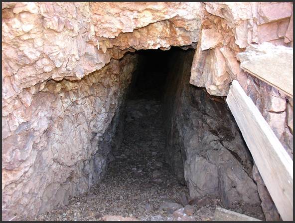
Figure 8, Second Adit
Figure 8
shows the second adit, west of the one in Figure 7. Both adits
probably contained narrow veins of ore that were extracted during the mining
process. I found no evidence of copper in the first dump and it is likely that
this mine was chasing a vein of gold. This adit is
characteristic of the rock formations commonly found in this area. The adit
literally follows the slope and angle of the vein. The height and width of the
adit was very conservative - that is, you could enter without stooping, and the
width at the entrance is not more than thirty inches.
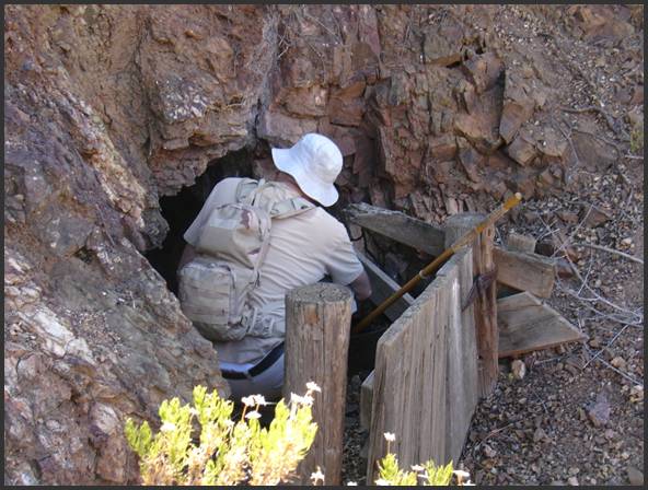
Figure 9, Entrance to Adit 3
Figure 9
shows the entrance to the third adit, which is farther west of Figure 8. This
is the only gated entrance at the mine site. It is again apparent that the
entrance is quite small. The presence of the gate may indicate that a winze
(vertical shaft connecting different levels of adits) lies beyond the entrance.
Although one of my hiking partners is examining the entrance, we did not go
beyond this opening. There is a rather sizable dump to the right of this photo
that contains a few hundred tons of waste rock.
Notice that
two of these adits contain structures built with wood posts, boards and planks.
They appear to be in generally good condition. Each adit
is protected by steep (nearly vertical) walls in this gulch, which has probably
protected the wood from rapid decay.
Initial
Assessment
An evaluation
of the first nine photos suggests the following:
1. The manner of construction of the
arrastre clearly indicates the use of more modern materials than are found at
the older, traditional “Mexican” arrastres.
2. Although the wall was unusually high,
the capacity for pulverizing ore was quite limited due to the narrow inner
dimensions.
3. Steel cables were not used for pulling
drag rocks in the 1800’s or at any earlier point in time.3
4. There is no convincing evidence that
mercury was used at the arrastre. Instead, it is likely that the pulverized ore
was taken to the “panning” site shown in Figure 5 where it could be gently
washed to separate gold from the waste material.
5. The adits at this mine were quite
small. The development of this mine shows considerable economy in effort and
expense. In other words, the adits were “just wide enough” to get the job done.
6. In comparison to mines that were high
producers of ore, the dumps at this site are not very large. This correlates
with the small dimensions of the adits, but also suggests that the tunnels and
drifts were not extensive. The “pay streak” at this mine, such as it was, must
have been very narrow.
7. Given the low-budget nature of this
site, the recovery of a few ounces of gold each month could have kept this
operation going.
Living
Conditions
Finally,
let’s examine the small settlement area near the mine. Figure 10 shows the only
wall at this site. It is not a dry stack and, importantly, it is not adobe. Instead,
this wall was built using a combination of mortar and local rock. The
coloration on the right face indicates that dirt was added to the mixture,
possibly as an “extender.”
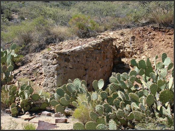
Figure 10, Settlement Wall
The wall is
actually pretty solid and shows no signs of weathering or erosion. Notice also there are three crude bricks in
the lower foreground near the cactus. I have not been able to piece together
the surface features, but the bricks might have been used in a fire pit or some
type of improvised oven. Because there are no other walls in the settlement
area, it is possible this structure may have served as a “lean to.”
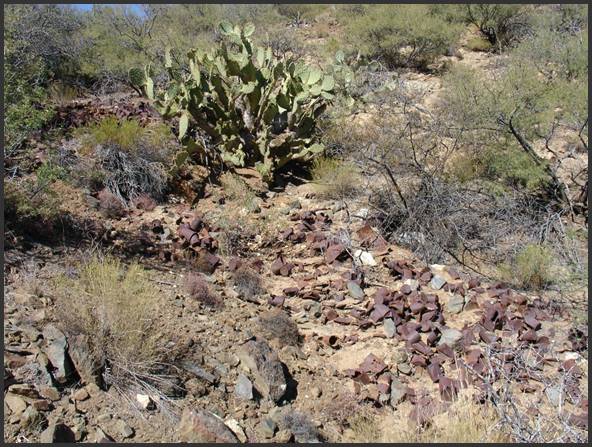
Figure 11, Debris Field at Settlement
Figure 11
shows a small portion of the trash dump at the mine settlement, which is uphill
and out of view to the left. The trash extends left and downhill from this location
for another twenty yards. Considering the modest nature of the mine, this is
one of the largest debris fields I have encountered.
Other
features of the settlement include the remains of a collapsed outdoor privy, a
burned out metal drum that was lined with cement, and a few boards and pieces
of pipe. The metal drum may have been an
open air fireplace. There is no evidence that heavy machinery or electrical generators
operated at the mine. In other words, the work and living conditions were about
as primitive as you could imagine.
Historical
Context
I do not know
when this mine was established or how long it operated. Surface features
strongly point to an occupation no earlier than the 1920’s, but it was more
likely established in the 1930’s. The Great Depression was a brutal time for
everyone – no jobs, lost homes and little hope. There are anecdotal records
that up to 20,000 people lived in the mining districts east of Wickenburg
during that time. This unnamed site is probably one of the locations where hopeful
people tried to scratch out a meager living.
How
to Get There
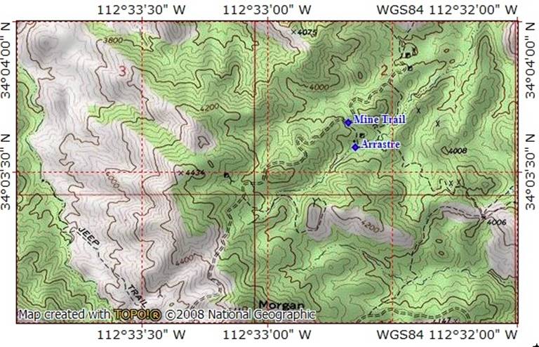
The route to
this mine is provided in the attached topo map. I should point out that the old
mine trail that crosses the northern flank of Morgan Butte is particularly
rough. It absolutely requires high
clearance 4WD or ATV type vehicles. The trail over Morgan Butte has not been
maintained for many decades and is bare granite with deep runoff trenches in
many locations. You should consider taking a back up vehicle if you make this
outing. The trail continues east into a basin and passes on the southern slope
of Table Mountain. It then drops into another basin before taking you to Roberts
Camp near the upper end of Buckskin Canyon. As rough as the Morgan Butte
segment of the trail can be, the portion that traverses Table Mountain is even
worse.
1.
From
the Wickenburg Rodeo Grounds, proceed east on Constellation Road.
2.
Turn
right onto Buckhorn Road at GPS N 34o 02’
32” by W 112o 36’ 46”.
3.
Turn
left at GPS N 34o 02’ 55” by W 112o
33’ 24”. This turnoff is easy to
miss. It is in the bottom of Slim Jim
Creek (upper end). There have been several washouts in the past few years and
the trail may not be obvious. Following
the trail, you will pass a corral and water tank on your right. Remain on the trail. It will lead you out of Slim Jim Creek.
4.
Bear
right at a mine gate and continue up the trail as it climbs the northern flank
of Morgan Butte in an easterly direction.
5.
You
will come to a livestock gate shortly after cresting the top of the trail on
Morgan Butte. This gate should always be closed.
6.
Continue
down the trail until you arrive at GPS N 34o
03’ 40” by W 112o 32’ 41”.
You have the option of either parking in this saddle or driving down the
trail to the mine settlement. Caution –
there are a lot of old nails on this portion of the trail. You might want to
check it out on foot before choosing to drive to the settlement and arrastre.
7.
The
arrastre is located at the bottom of the trail (south of the gulch) at GPS N 34o 03’ 35” by W 112o 32’ 38”.
8.
Follow
the gulch uphill (west) to locate the adits, well and panning area. See Reference #3 for the location of the
first adit.
Before
You Go
As previously
stated, this area is a combination of private, deeded land and BLM/State Trust
land. If you meet someone, they may very well be a land owner. Always be
courteous and respectful. Ranchers have grazing leases in the area and have a
vital economic interest in the well-being of their cattle.
Bring plenty
of water and energy snacks for this outing. Be aware of weather conditions and
high temperatures. The gulch and hillsides leading to the adits are covered
with thick foliage. Dress appropriately.
Always let
someone know where you will be and when you plan to return.
References:
1.
There
are quite a number of mine shafts in the area east of Wickenburg that are only eight
to 15 feet in depth. In most cases,
there is little or no evidence of useful results. Many of these were “squatter”
prospects. Others gave only the appearance of being a legitimate mining
operation. Ranchers in this area have told me there were several thousand
people living in the open desert and at old settlements during the Depression.
2.
USGS
Morgan Butte Quadrangle map. Morgan Butte is located at N 34o 03’
03” by W 112o 33’ 06” (WGS84). See sections 1-4 and 9-12 as the
primary reference area in this article.
3.
Here
are two sets of GPS coordinates. The first is for one of the adits and the
second set is for the arrastre: Upper
adit – N 34o 03’ 24” by W 112o 32’ 49”. Arrastre – N 34o 03’ 35” by W 112o
32’ 38”.
4.
Steel
cable (also known as wire rope) was first developed in the 1830’s by a German
mining engineer named Wilhelm Albert and came into use in the late nineteenth
century for hoisting heavy loads in deep mines. The cables shown in this
article do not match the type of cable used in the latter portion of the 1800’s.
American Pioneer & Cemetery Research Project
Internet
Presentation
Version 052409
SUPPORT APCRP
BECOME A BOOSTER
WebMaster: Neal Du Shane
Copyright
© 2009 Neal Du Shane
All rights reserved. Information contained within this
website may be used
for personal family history purposes, but not for financial profit of any kind.
All contents of this website are willed to the American Pioneer & Cemetery
Research Project (APCRP).
HOME | BOOSTER | CEMETERIES | EDUCATION | GHOST TOWNS | HEADSTONE
MINOTTO | PICTURES | ROADS | JACK SWILLING | TEN DAY TRAMPS