HOME | BOOSTER | CEMETERIES | EDUCATION
| GHOST TOWNS
| HEADSTONE
MINOTTO
| PICTURES
| ROADS
| JACK SWILLING
| TEN DAY TRAMPS
Internet Research Presentation
Version 102507
CULLING’S WELL,
October 24, 2007
I want to thank
Proceed west of Wickenburg on Hwy 60, until you reach mile marker 72, slow at this point but proceed west on Hwy 60, until the first dirt road on the right leading north.
Depending on the severity of the rain in the area, this can be a tranquil ride or full of Mother Nature’s wrath to road construction’s. In either case it is advised to have four-wheel drive as the soil is the consistence of soft sand, converting to clay with some washouts tossed in. In all cases it could be easy to get stuck.
As you travel north on this desert road, the fist landmark will be crossing the railroad track at 0.6 tenths mile. Stop and look both ways as you never know.
At 2.2 miles you come to a cattle guard. After crossing the cattle guard the main road turns to the right. Continue on the road leading straight ahead of you or approximately north. The road straight ahead diminishes in quality and narrows considerably.
Proceed approximately ½ mile north and looking to your 11:00 O’clock position on your horizon, you will see a very large cement monument standing about 5’ tall in the distance. At this point we turned left for 900’ then turned north again to the edge of Culling’s Well. Depending on the run off, work your way toward this cement structure on the best route you can find.
CAUTION: If the area around Culling’s Well has had rain we would suggest you consider walking the last quarter mile. This is a clay earth and gets extremely slippery when wet. Under these conditions it is easy to get your vehicle stuck, and it’s a long walk back.
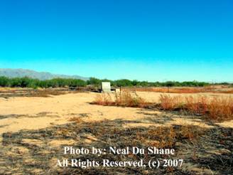
Culling’s Well 2007
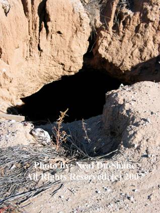
We parked about a ¼ mile from the cement monument and walked in. Be careful as the hole for Culling’s Well (Left) is large and deep, not something you want to fall into. The Monument and Culling’s Well are fenced as of this writing but could change.
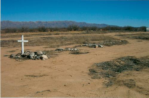
Photo courtesy: Pat Ryland Spring 2007
Last spring when Pat and Gary was here the wooden marker for Charles Culling’s was still standing. It is believed with the volume of rain and run off this past summer the wooden marker has been washed away. Although some termite burrows were visible on the surface, it is possible they have destroyed the wooden cross. On Mr. Culling’s grave there was one bone laid among the rocks, possible placed there due to exposure from the run off?
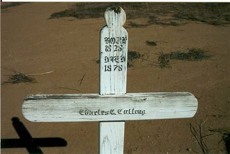
Charley C. Culling Marker, Photo Courtesy Pat Ryland, spring 2007
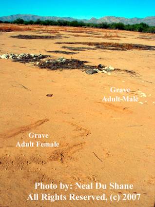
The graves are laid out in a straight line of approximately 100’ long. Mr. Charles Culling’s being the farthest grave to the west. There are approximately 5 or 6 graves that have rocks piled to outline the grave site. No markers remain as of this visit.
Our research revealed all the visible graves were adult male. In the same straight line past the marked graves we identified an additional 8 adult male graves. In the middle of this straight line of 15 adult males, in what might be considered a second row to the south we found two adult female graves.
To fence this
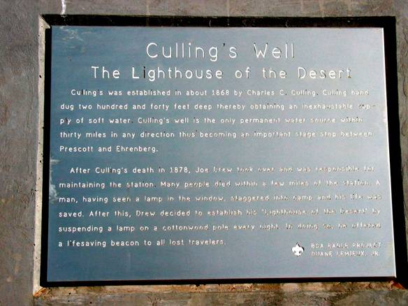
Plaque in Monument, Photo by: Neal Du Shane, All Rights Reserved © 2007
Culling’s Well
The Lighthouse of the Desert
Culling’s was established in about 1868 by Charles C.
Culling. Culling hand dug two hundred and forty feet deep thereby obtaining an inexhaustible
supply of soft water. Culling’s Well
is the only permanent water source within thirty miles in any direction thus
becoming an important state stop between Prescott and Ehrenberg.
After
Culling’s death in 1878, Joe Drew took over and was
responsible for maintain the station. Many people died within a few miles of
the station. A man, having seen a lamp in the window, staggered into camp and
his life was saved. After this, Drew decided to establish his “Lighthouse of
the Desert” by suspending a lamp on the cottonwood pole every night. In doing
so, he offered a lifesaving beacon to all lost travelers.
BSA
Eagle Project
Duane
Lemieux, Jr.
In walking the area to the south of this main Culling’s
Another trip will allow us the time to completely research this area for graves, mark and document them for history. It is very likely many of these graves were of travelers passing through this main artery in years past. Names will never be known as identification of the deceased was never known in the first place.
“A
Lighthouse In The Desert”
The late Carlos L. Hernandez wrote a book titled “A Lighthouse In The Desert” about the life and times at Culling’s Well. It explains the history relating to some of the residents. The Hernandez family has been gracious enough to allow Arizona Pioneer & Cemetery Research Project to publish this book on our web site. You can Link to the book and read or print a copy at: INTERNET\Lighthouse_In_The_Desert.htm
Internet Research Presentation
Version 102507
WebMaster: Neal Du Shane
HOME | BOOSTER | CEMETERIES | EDUCATION
| GHOST TOWNS
| HEADSTONE
MINOTTO
| PICTURES
| ROADS
| JACK SWILLING
| TEN DAY TRAMPS