American Pioneer & Cemetery Research Project
Internet Presentation
Version 050412
LOPEZ RANCH CEMETERY
N34 14 9.11, W113 46
53.76 (WGS84)
Mohave County, Arizona
By
Kathy Block
APCRP Historical
While researching information about
Swansea, I found a photo on the Internet with this caption: “Lopez Ranch
Graves: Graves of former owners of Lopez Ranch in the Arizona desert. This
ranch produced crops to supply to the mines at Swansea, which is now preserved
and a fun place to visit.” The photo showed at least 4 rock-covered mounds with
wooden crosses laying on them surrounded by bushes, and the main road from the
Bill Williams River crossing coming up the hill in the background.
|
|
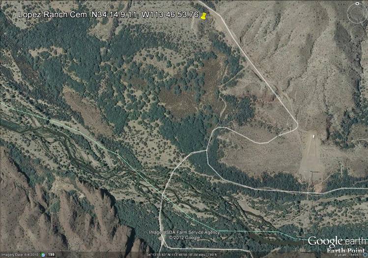
Google Earth Map showing
location. Courtesy Neal Du Shane.
This remote site on the north bank of
the Bill Williams River is approximately 12 miles Northeast of Swansea, less
than a mile north of the river crossing, downstream from a natural gas pipeline
crossing.
A kiosk at Swansea gave this information about
OHV Adventures:
“EL PASO PIPELINE & BILL WILLIAMS
RIVER CROSSING. The above-ground pipeline continues
northeast, up-and-down across the terrain to a large wash where it can be seen
joining the main three foot diameter El Paso Natural Gas Pipeline, which
crosses the Bill Williams River. The river crossing for OHVs is just downstream
of the pipeline crossing. Beware: the sand is very loose and the river crossing
can be deep! The route cuts through a portion of the historic Lopez Ranch,
so please respect private property.” (Italics by author.)
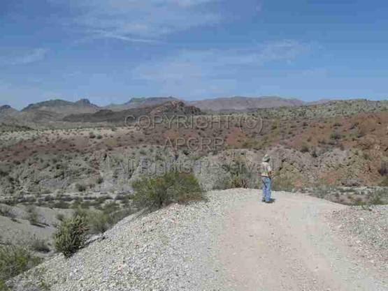
In April 2012, we drove north from
Swansea to the river crossing on a high-clearance road that sometimes went
steeply into and out of steep-sided washes. Part of the road followed the
above-mentioned gas pipeline. In places, this road dropped sharply off ridges. Ed needed to walk ahead to check out the
road! Occasionally the pipeline crossed washes, suspended above ground.
|
Photo courtesy Author |
Photo courtesy Author |
 Ed
Block checking downhill drop into large wash, en route to the river.
Ed
Block checking downhill drop into large wash, en route to the river.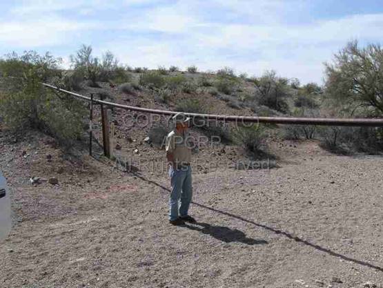 Ed
Block examines pipe crossing over wash.
Ed
Block examines pipe crossing over wash.
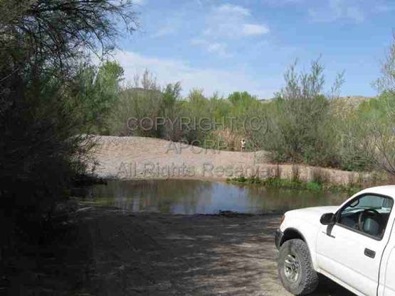
The Bill Williams River crossing was
challenging. Ed took off his jeans and
boots and waded out into cold, clear water. He found a crossing about a foot
deep. We first skirted a shallow sandy backwater and then plunged full speed
thru the deeper water, on the other side of a sandy island. If we had stalled,
we possibly would have become stuck in the sandy bottom!
|
Bill Williams River crossing –
approximately one foot deep. Photo courtesy Author |
Ed Block checking water depth.
Main channel north side of Sand Island. Photo courtesy Author |
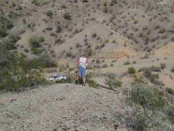
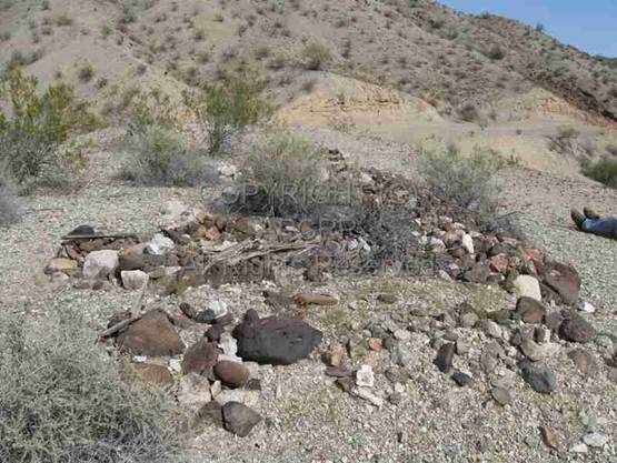
The rough road on the north side led
through thick brush to a dirt road going uphill to the north. While on this road, we saw a ridge with five
graves – the Lopez Ranch Cemetery. They are on a north-south trending bluff at
the southern edge of the Rawhide Mountains. A pull-off to the left gives
parking access to the trail to the cemetery.
A steep 150 foot long path with a pipe
across the start (to block access) led up from the road. The five graves are
side by side, approximately six feet apart, oriented north to south with the
heads pointed north. Three are covered with closely packed stones and the other
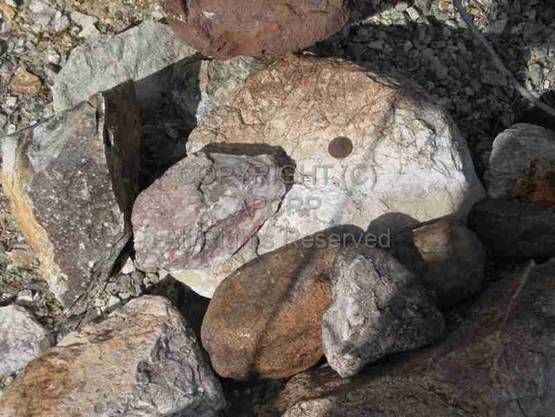
two had fewer stones and more gravel. At
the time of our visit, one grave had a 2011 nickel on it; two had pennies –
1999 and 2011. (One can examine coins left on graves to have a rough idea of
when the graves were visited.) A recent
animal bone was on the foot of one grave. (Dr. William Halliday, a retired
heart surgeon, confirmed it was an animal, not human, bone.) There are four adult
males, one adult female, according to our on-site
research. Some of the graves had brush
growing on and around them, and all had decaying, unreadable wooden crosses
held together with rusty bailing wire. The fairly bare top of the ridge was
about 40 feet wide, north to south, and 100 feet long, east to west.
|
|
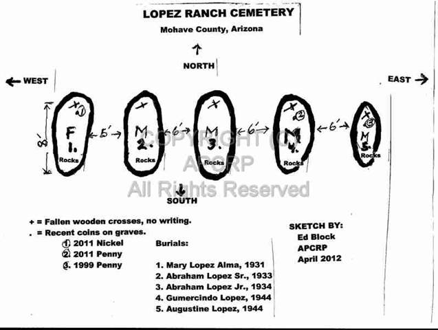
Map of cemetery and
graves by Ed Block.
“X” represents position
of crosses and or head in each grave.
|
Author looks down the steep 150
foot long path to road below. Photo courtesy Ed Block. |
1999 nickel placed on grave.
Photo courtesy Author. |
|
2011 penny placed on another
grave. Photo courtesy Author |
Animal bone at foot of a grave. Photo courtesy Author |

|
Looking North downhill toward
southern edge of Rawhide Mountains. Ed Block resting at right (10 Toes up). Photo courtesy
Author. |
Grave with a decayed unreadable
wooden cross. Photo courtesy Author. |

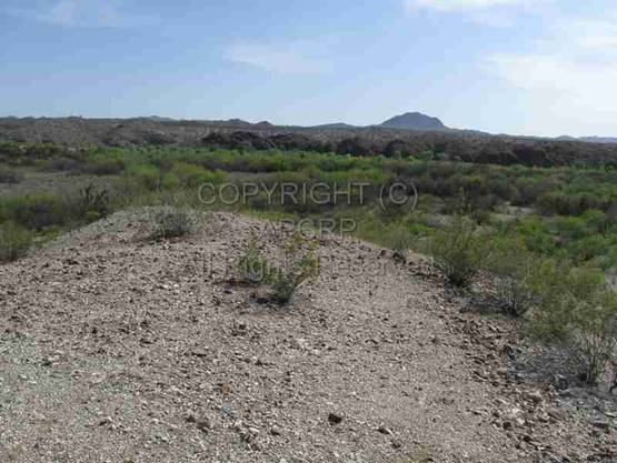
There is a nice view to the south from
the bluff, which is 40 to 60 feet high, to the Bill Williams River below. Looking east, you can see the gas pipeline
crossing upriver. Back down the path, north toward the main road, the southern
edge of the Rawhide Mountains begins. A sandy wash is below the bluff, to the
west.
|
|
|
|
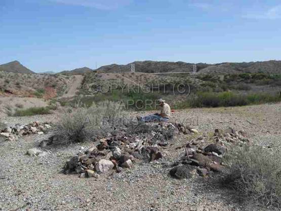
Looking
South towards the Bill Williams River |
Ed
Block researches the Lopez Ranch Cemetery with pipe line in background. |
In 1994 a report was written for El
Paso Natural Gas Company that includes information about the Lopez Ranch and
Cemetery. It listed the five burials in the cemetery. I was able to locate Death
Certificate’s for 4 of the 5 burials. Here's what they contained:
Grave
#1. MARY LOPEZ ALMA. No Death Certificate.
Apparently she was the first burial in the family plot. She had returned from a
camping trip to Zion National Park and became ill and died without a doctor
present, in 1931. She was married and the daughter of Abraham Lopez Sr. and
Maria Rojas Lopez, born sometime after their marriage in 1900. She was one of
13 children.
Grave
#2. ABRAHAM R. LOPEZ,
SR. Death Certificate. Dated November 8, 1933 and filed in Yuma
County. (La Paz County, where Swansea
was located, didn't become a separate county until 1983. The Bill Williams
River divides this county from Mohave County.) His residence was given as
“Ranch on Bill Williams River”. He died of inflammation of kidneys and bladder,
and was a rancher and “farming.” He was
born in 1878 and left a spouse, Maria R. Lopez. The Death Certificate states he
was “buried on the ranch” the next day, Nov. 9, 1933, by “family.” The Death
Certificate was not filed until Nov.20, 1933 and was signed “August R. Lopez,
Jr.” in Bouse, Arizona. The family
attributed his death to “miner's consumption.” He had worked at various mines
and at Swansea. He was buried beside his
daughter.
GRAVE
#3. ABRAHAM LOPEZ, JR.
Death Certificate. He was born July 16, 1913 and died November 17, 1934,
age 21 years, 4 months, 1 day. He was
single. He died from first and second degree burns of both arms, chest, back,
and buttocks, finally dying from shock 2 days later. He'd just bought a Model A
Ford and was using a gallows frame at Swansea as a hoist to work on the car.
The carbide light he was using was knocked into a bucket of gasoline when the
car shifted; causing an explosion that killed him. He was taken to the cemetery
and buried beside his father.
Grave
#4. GUMERCINDO LOPEZ.
The Death Certificate misspells his name as “Cumercundo” He was born in 1926
and was 17 years, 11 months, and 14 days old when he died from a fractured
skull in a jeep accident on January 10, 1944. He was a laborer, miner, and a
soldier at Camp Bouse during the final years of World War II. He was the son of
Abraham Sr. and Marie Rojas Lopez, and was buried 4 days later next to his
brother Abraham Jr. The burial place on the Death Certificate was noted as “a
ranch near Bouse”.
Grave
#5. AUGUSTINE RODRIGUEZ
LOPEZ. The Death Certificate states he was born July 6, 1907 and died
October 25, 1944. He was married to Hattie Lopez. His parents were Abraham Lopez
and Marie Rojaz Lopez. The cause of death was given as “accidental drowning.”
He was working at Parker Dam with a maintenance crew on a tugboat, dredging
sand bars from an intake area when he was caught in a cable and pulled
underwater. He was the last family member to be buried in the Lopez Cemetery,
and occupies the eastern end next to his brother Gumercindo.
You can see that this family suffered
the tragic loss of the father and one daughter and three sons, all buried in
Lopez Ranch Cemetery.
The Lopez Family ranch began with the
marriage of Abraham Lopez and Maria Rojas in 1900. She lived in Santa Maria, a
town that used to exist near where the Santa Maria and Big Sandy rivers join to
form the Bill Williams River. The site was flooded when Alamo Lake Dam was
built. In the 1920s, Abraham and Maria bought a ranch on the north side of the
Bill Williams River about six miles S.W. of their later ranch. However, they
soon learned they'd been swindled by a Swansea school teacher who sold them the
land but didn't have title to the land! It was actually Federal Land that
hadn't yet been surveyed. (It wasn't mapped until April 1949.)
Finally, Leo Lopez, a son of the late
Abraham Lopez Sr., filed a homestead application in June 2, 1950, which was
considered “late” in history of homestead applications in Arizona. It took two
years and various legal difficulties to gain title to land the Lopez family
thought they'd legitimately purchased almost 30 years earlier!
Government Land Office records shared
by Bonnie Helten show the homestead patent was dated March 20, 1952. In ornate formal language, the land, located
by the Bill Williams River, was granted to “Leo Lopez and his heirs and assigns
forever, subject to any vested and accrued water rights for mining,
agricultural, manufacturing, or other purposes, and rights to ditches and
reservoirs used in connection with such water rights.”
An
interesting provision of this document, issued during the “cold war,” was that
the U.S. Government reserved the right to enter the land and prospect for,
mine, and remove ”all uranium, thorium, or any other material which is or may be determined to be peculiarly essential
to the provisions of the Act of August 1, 1946.”
The
main minerals mined in this area were gold, silver, and copper. There were
remains of an arrastra apparently near the river on the east side of the ranch,
suggesting some earlier mining activity in the area.
|
|
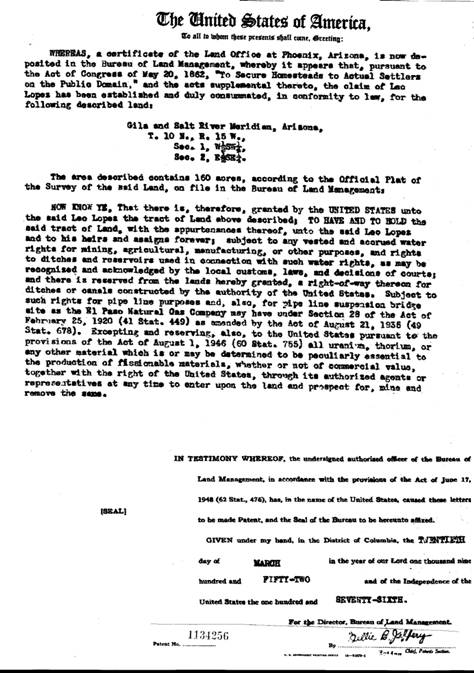
Land Patent Certificate,
Lopez Ranch,
courtesy
Bonnie Helten.
The location of this Lopez homestead
by the Bill Williams River provided productive bottomlands along the river and
water for field irrigation. There are check dams and wells shown on maps of the
area. A survey map for 1949, filed with BLM in May, 1951, before the land was
patented, indicated there was a farmstead with three buildings, a ditch and
fields that were labeled “Lopez”, with no cemetery shown. We saw no signs of an active ranch or
buildings except for an unused-looking road with a gate to the west near the river
with a sign, “Private Ranch Road.” There were no fresh livestock signs. A fence
began at the river, disappeared near the cemetery, and reappeared along the
road as we drove north past the bluff.
Swansea, to which the ranch supposedly
supplied produce, was active mostly from 1911 to 1929 (see
APCRP, Swansea Cemetery),
The Lopez family lived in a large frame house with an adobe food storage
building and frame bunkhouse, corrals and pens for livestock (cattle, horses,
pigs, and chickens.) There are modern day sightings of feral pigs as well as
burros in the area. The father, Abraham, had planned to build a new house on
the bluff east of the ranch to be on higher ground that would not be flooded,
but this was never completed.
The Lopez family farmed about 100
acres, irrigating the crops with a diversion ditch from the Bill Williams
River. This is shown on some maps. They cleverly picked a location where
bedrock forced a continuous stream of water to the surface. Figs and
pomegranate trees were planted along the ditch and peanuts were grown nearby!
Crops that may have been sold in Swansea to hungry miners were; potatoes,
melons, vegetables and fruits. This ditch, modified in the 1940s, curved around
the bases of the river bluff below the cemetery area. The family was said to be
“subsistence rather than cash oriented.” They butchered their own meat and wild
game. The meat was preserved by jerking, and also hung in the adobe storehouse
during cool weather! Shoes and leather goods were made from
the
hides. Work at the Swansea mines supplemented their income.
The children went to school in Swansea
(maybe where their father met the crooked teacher?) and stayed in town during
the week and walked home to the ranch on weekends. After the mine closed in
1937, their mother, Maria Lopez, moved to Bouse with the young children, who
could stay with her while her older sons stayed on the ranch.
Angelina Lopez Robbins, a member of
the Colorado River Indian Tribes, is the daughter of Augustine Lopez. She
recalled the ranch as a “wonderful place for children.” The ranch flooded at
times and once she retreated to the ridge where the graves are located to wait
out a storm. Young chickens and pigs were washed away by the flood waters!
Leo Lopez, who eventually received
title to the ranch, was the last of the family members to reside on the ranch.
He sold it afterwards and worked the rest of his life in a ministry in Nogales,
and died in December, 1986. There were a number of owners since then. One
apparently demolished the ranch buildings and leveled the area, in the late
1950s, removing all evidence of this once thriving homestead. The fields were abandoned possibly due to a
flood in the mid -1990s that scoured away much of the usable soil or deposited
gravels in the fields. This could have been from major water releases from
Alamo Lake Dam, which is 10 miles upstream.
An 1881 publication, “The Resources of
Arizona: Its Mineral, Farming, and Grazing Lands, etc.etc.: A Manual of
Reliable Information Concerning the Territory.” by Patrick Hamilton, Published
Under Authority of the Legislature, Prescott, Arizona, had these comments about
the Big Sandy area upriver from Lopez Ranch:
“The soil is equally as rich and productive, (as
in Yuma) but it requires capital to open canals, throw up embankments, and put
the land in a condition for successful cultivation. At present farming in Mohave is confined to
the Big Sandy, in the southern part of the county, where there are about 1,000
acres under cultivation, producing fine crops of grain, vegetables and fruit. Successful
farming in Arizona depends entirely on irrigation. There are thousands of acres
of productive land in the leading valleys, which can be made available by a
proper distribution of the present water supply. While the wealth of Arizona is
in its mines, agriculture will always be a profitable calling, and the products
of the soil command a good price. It is not the intention to invite hither a
large agricultural population....the area of land which can be brought under
cultivation is limited, and must remain so until artesian water shall send
forth its fructifying stream, and make the dry valleys and plains to blossom as
the rose.”
Historically the Bill Williams River
was a major route of travel and exploration, beginning around 1860, when gold
and silver mining communities such as Planet Ranch on the river and Signal, on
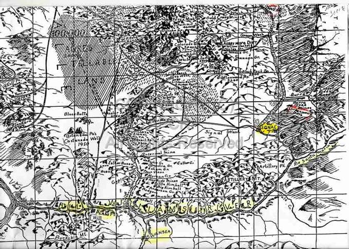
the Big Sandy River, were established in the region. See the 1912 map “A Birds
-Eye View of Territory Tributary to Yucca, AZ. By A.M. Stene, 1912.”, that shows some of these sites,
|
Historic 1912 map of area. |
Swansea depended on water from the
Bill Williams River and had a pumping plant on the river 3.7 miles northwest
from town. All that remains of the Swansea Pumping Plant, reached by a 4x4 road
just north of Swansea, is a concrete tank and some footings on the river bank.
A short brushy path leads to the water.
In addition to the ruins of Swansea
and its mines and mill preserved by the BLM, there is evidence of mining
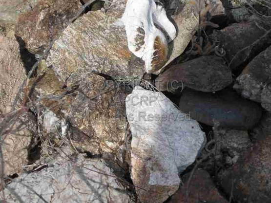
activities throughout the area. We found an adit in a remote wash, northeast of
Lopez Ranch Cemetery, with a nearby pile of copper ore, and old cans, which may
sometimes be useful to date old mining camps. We found one small rusted can
that Allan Hall dated from 1887 to 1904 by its distinctive “Norton's side
seam.”
|
Site of old mining camp with adit, pile of copper ore and old cans.
Photo courtesy Author. |

The earthen dam that formed Alamo Lake
was completed in 1968. This dam was built just below the confluence of the
Santa Maria and Big Sandy Rivers to provide water for irrigation and flood
control on the Bill Williams River that now flows 46.3 miles into the Colorado River
just north of Parker Dam. The dam and Alamo Lake were approved by Congress to
provide public recreation – boating, fishing, and bird watching. Alamo Lake is capable of capturing large
amounts of water in a relatively short time. The lake once rose 11 vertical
feet in one night. It fluctuates according to drought and rain conditions. On
the east side of Alamo Lake is a State Park. There are also several small
cemeteries near the Lake, with one grave near the entrance to the Park. The west
side of the lake is undeveloped and is bordered by the Rawhide Mountains
Wilderness. There is evidence of previous mining efforts with shafts, adits,
tailings piles, and old cabins. Many mines were flooded by the lake. Some
graves may be in the area, also.
The lower Bill Williams River was
changed by the dam. The once extensive cottonwood, willow, and mesquite forests
were largely lost and the wildlife that depended on these habitats was impacted
as well. The Bill Williams River National Wildlife Refuge was created in 1941
in an area along the river where there is one of the last stands of natural;
flood regenerated cottonwood and willow forests and floating reed beds as it
flows into the Colorado River. Now, 344 species of birds are listed as residing
year-round or seasonally in the Refuge.
There are also deer, wild burros, javelina, coyotes, mountain lions, and
small mammals living in the brushy, wild areas, and big horn sheep in the rocky
cliffs above the river. This area is accessed by a gravel road, Planet Ranch
Road, going east from Highway 95 just south of a bridge over the river. This
road ends about 7 miles from the highway. It used to access a ford of the river
and Planet Ranch, but flooded out in the 1970s, and is blocked by concrete
barricades.
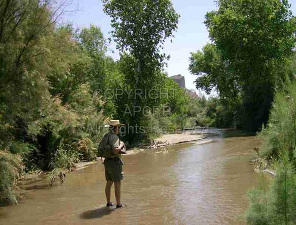
|
Ed Block hiking Bill Williams River. Photo
courtesy Author. |
The man who gave the river its name
was a colorful trapper and mountain man named William Sherley Williams, He
was most often described as tall,
skinny, gangly, with wild woolly red hair, a luxuriant beard, eccentric to the
point of insanity, and having questionable hygiene!. “Old Bill” Williams was
known as “the greatest free trapper of 'em all.” Bill Williams had come west as
a missionary to the Osage Indians, but supposedly “they converted him.” He was
born January 3, 1787 on Horse Creek in Rutherford County, North Carolina, the fourth of 9 children of Welch ancestry. He learned
various Native American languages as a sergeant and scout with the Mississippi
Mounted Rangers during the War of 1812.
He had an Osage wife, named A-Ci'n-Ga (Wind Blossom), the daughter of a
chief. She died after bearing two daughters, Mary Ann in 1814 and Sarah around
1816. Bill Williams may have had two
more wives, and lived with the Osage for 25 years. His Native American name was
“Lone Elk.” as he never returned to European-American life. He roamed 30 years in the wilds of the
Southwest. He lived in Taos, New Mexico with a Mexican widow and her three
kids, and had a son Jose with her.
There is some mystery about his burial place.
Some records say that on March 14, 1849, a war party of Ute’s killed him and a
companion, Dr. Ben Kern, near the headwaters of the Rio Grande in Southern
Colorado, and the bodies were never reclaimed. Other stories say he froze to death
on a lonely mountain pass. Legends also suggest he is lying in an unmarked
grave in the mountains that bear his name.
There is a monument to him near his birthplace in North Carolina that
reads: “'Old Bill Williams'. Well-known guide and trapper.
Helped survey Santa Fe Trail. Guided the ill-fated Fremont
expedition of 1848. Was born near here in 1787.”
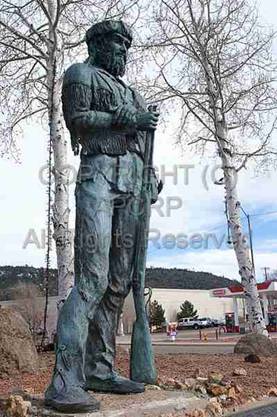
There is also an 8- foot- tall sculpture by B.R. Pettit erected in 1980 in the
Bill Williams Memorial Park in Williams, Arizona.
|
Bill Williams Statue, in Bill Williams Memorial Park, Williams, AZ |
|
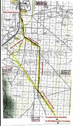
Route to pipeline road from Exit 25 on I-40. Courtesy Author. |
Downriver from the Lopez Ranch is the
well-known Planet Ranch on the south side of the Bill Williams River. It was
evaluated in 2005 to determine the acreages and habitat types which could be
created in support of a wildlife area. Three documented cultural sites were
found near the farming area. There is a cemetery near Planet Ranch, called
Esquerra Cemetery. It is located 2 - 3 miles to the west and across the river
from the historic Planet settlement site, and APCRP has nine Death Certificates
for it on file. At the time the farm
area had 45 fields totaling 2,205 acres, 15 of which were flood irrigated (428
acres). Eleven wells and 21 groundwater monitoring wells provided water also.
In 2006 the city of Scottsdale, Arizona which had formerly owned Planet Ranch
and planned to export water from it, sold the ranch to Phelps Dodge mining
company, which is operating it as a nature reserve under a government program
for companies to restore habitat in one area to balance environmental damage
caused elsewhere. Many copper mines have been opened or reopened northwest of
Swansea.
The ranching efforts at Planet Ranch
have been abandoned. In 1978, Planet Ranch was used as by the Defense Nuclear
Agency to study the blast effects of simultaneous detonations. The tests were
done at Miner's Bluff.
After researching the Lopez Ranch
Cemetery, Ed and I headed north towards Alamo Lake Road that winds east from
I-40 to the west side of Alamo Lake. Somewhere we took a wrong turn and ended
up in a series of progressively smaller tracks through colorful washes with red
rock sides in a very wild, remote area. We passed various old mining efforts.
Ed often used a compass to navigate us to the north. Eventually we came to a
rough track on a ridge overlooking Alamo Lake Road to the north. We had to drive several miles east towards
Rawhide Mountain, until we finally were able to descend to Alamo Lake
Road. We decided we should have stayed
on the main pipeline road! But, we would have missed experiencing some rugged,
scenic country. A map of the pipeline shows the road emerging on Old Trails
Highway.
You will need a high-clearance
vehicle, possibly 4x4, for some stretches of the roads north from Swansea and
to cross the Bill Williams River.
The author wishes to express a special
thank you to: Neal Du Shane for the Google Earth map; Bonnie Helten for finding
and sharing the Land Office patent documents; Allan Hall for his astute
analysis of the age of old cans from mining camps; and Ed Block for patiently
negotiating the back country roads to find Lopez Cemetery and for measuring and
drawing the graves for his detailed map of the Cemetery.
The Lopez Ranch Cemetery
is on private property, although not posted, please respect property owner
rights, help protect
and preserve this historic site for others to enjoy for generations to come.
American Pioneer & Cemetery Research Project
Internet Presentation
Version 050412
WebMaster:
Neal Du Shane
Copyright
© 2012 Neal Du Shane
All rights reserved. Information contained within this website
may be used
for personal family history purposes, but not for
financial profit or gain.
All contents of this website are willed to the
American Pioneer & Cemetery Research Project (APCRP).
HOME | BOOSTER | CEMETERIES | EDUCATION | GHOST TOWNS | HEADSTONE
MINOTTO | PICTURES | ROADS | JACK SWILLING | TEN DAY TRAMPS